Noah's Flood Geology
or
Evolutionists Are from the Same Cloth as the Anti-Christ
Not long ago, on June 16, the Iraqi Kurds visited Russia: "Russian officials have told a delegation from Kurdistan Regional Government (KRG) that the region should not think about holding a referendum or declaring the region's independence from Baghdad before the region's political parties resolve their internal rifts." Yes, but these words declare Russia in favor of separation under certain conditions, which is going further toward Kurdish desires than the Americans are willing to go. Russia's invitation is coming at the right time, and these same Kurds visited Iran this week. I'm wondering whether the Americans have made up their mind to side with the Sunni rather than with Kurds, once and for all, or whether they will teeter for a while longer.
Something must have happened during the Kurd assault on Raqqah, which quickly turned into an assault on Manbij, with the Kurds, possibly, surprised about that change. There were fears in the West that Kurds were edging close to Russia, which doesn't seem correct if these Kurds were happy about their partnership with the US. Western media would never speak on the Kurd invasion of Manbij without also giving undo credit to the allied American forces, but I say the Kurds were betrayed / abandoned by the Americans at that time (while the latter put up a show to make the partnership seem real). That can explain the June-22 headline, "Why Syrian Kurds are Cooperating with Russia." At the start of the Manbij invasion (first week of June), the Americans were saying that, in time, they would attack Raqqah together with the Kurds, but since then the Americans have given the Kurds reason to forsake them, leaving the Raqqah operation up in the air as to whether it will take place at all.
The Americans probably had the hope of turning the Syrian Kurds against Assad, and there have been some clashes between the two, even this past week. "Buthaina Shaaban, political and media adviser to the Syrian regime, said in a Feb. 20 [2016] statement that the Kurds are cooperating with the regime through a Russian agreement." It's probably not what the Russians wanted the Syrians to say publicly, but there you have it. It explains why the Americans started to wear Kurd logos on their uniforms, in an effort to take the Kurds from a close relationship with Russia. There was only one way to accomplish this, pretend with the Kurds to fight ISIS in Raqqah. But instead of doing that, they ended up in Manbij, which plays second fiddle for ISIS as compared to Raqqah. The way in which the loyalties of the Kurds ends up, as prophecy begins to transpire, is important because prophecy pits them, if they are the Medes of Isaiah, against the anti-Christ, and moreover there is logic in that Arabs, not Kurds, will join the anti-Christ against Egypt and Israel just as soon as he takes Damascus.
https://newcoldwar.org/syrias-kurds-cooperating-russia/The Kurds want only one thing from the Americans, help with establishing and maintaining their own province in Syria. The Americans may have promised them this thing under the condition that the Kurds turn and fight Assad. If that condition was made a demand, then this week's developments suggest that the Kurds are not willing to make the Americans happy. Last week, the Americans announced that they were not prepared to do what the Kurds desired even for Manbij, suggesting that the Kurds are willing to entertain an opposing strategy: to use Russia to convince Assad to give the Kurds their own province (or call it what you will). If true that Kurds attacked Assad's forces last week, it may reveal that the Kurds are divided on which of the two strategies to go with. The Americans are, for sure, using a carrot on a stick to keep the Kurds in their camp, but I am unsure how the Russians are dealing with this secretly. One expects the Russians not to jeopardize their close relationship with Assad, meaning the Kurds look like they are out of luck in using either superpower. But they seem to be leaning toward Russia because the latter, unlike the West, wants them to participate in talks on the shape of future Syria. Russia has been bold and repetitive for the need of Syrian Kurds to participate, but the West has not played the same tune at all, giving the impression that the West has no respect for these Kurds. The Kurds feel this. That's why the American alliance with these Kurds is nothing but throwing them dog bones for to make them play tricks.
In vengeance, I can see the Kurds joining Assad in the taking of Raqqah. But that won't happen until the Kurds have come to a deal with Assad. Moreover, the Kurds need to take Manbij first. It's rare to come across articles on the progress in Manbij. Here's one from July 1: "These forces were thus able to liberate all of Manbij's countryside...barely one month after operations began. By June 28, the SDF [Kurdish-Arab alliance] had gained control of one-third of the city, after the liberation of the traffic police building, southwest Manbij."
http://www.al-monitor.com/pulse/originals/2016/07/syria-kurdish-forces-liberate-manbij-turkey-border.htmlDays after writing the above, this came out on July 10:
US-led coalition left Kurdish-Arab forces in Syria without cover during an advance to liberate the city of Manbij from the Islamic State (IS) jihadist group, a Kurdish militia source told RIA Novosti on Thursday...."A few days ago, coalition forces have ceased providing fire support to the {Syrian} Democratic Forces advancing on Manbij," the source said.
The report, published by The Washington Post earlier in the day and citing US officials familiar with the events, claimed that the coalition's diversion led to the failure of the rebel offensive.
In the meantime, the Kurdish army claims to have all but defeated ISIS in Manbij.
It's not easy to find the progress of Assad against Raqqah. With Russia wanting to keep a Kurdish card, we may find that Russia is not too eager to help Assad in Raqqah, until Assad comes to an agreement with the Kurds. If no agreement can be reached, which of these parties will end up attacking Raqqah first? It seems the ISIS rats are losing everywhere; now is the time to destroy their headquarters in Raqqah too.
Under Obama, the FBI and Obama himself have powers over the media that they are not supposed to possess:
"The fact that the Justice Department has secret rules to identify journalists' confidential sources shows that the DOJ has been disingenuous in its public statements about investigating members of the media," Cope stated.The Justice Department's public guidelines, Cope noted, generally require attorney general approval before subpoenas, court orders and warrants may be issued for journalists' records.
However, Cope continued, the leaked rules indicate that those public guidelines do not apply to NSLs [National Security Letters], meaning that the FBI can seek journalists' records without US Attorney General's approval.
"This is plainly contrary to both the letter and spirit of the DOJ's public guidelines," Cope argued. "It is all the more concerning because NSLs are not subject to judicial oversight and usually prohibit recipients from saying that they have received one, or notifying customers that they are the target of an NSL."
http://sputniknews.com/us/20160706/1042547050/us-fbi-journalist-nsl.html
Not only does the FBI not need court approval to direct the specifics of a National Security Letter, but the FBI happens to be the authority that issues the letters in the first place. The FBI has a right to see a list of all telephone calls (the receivers of the calls) that the letter's recipient has made. So, for example, if the FBI could accuse a certain media reporter of being careless with a matter touching ever-so-slightly on national security, the FBI could abuse this authority and investigate the reporter (to a certain degree) with no one but the reporter knowing, and the latter is forbidden to tell anyone about the letter or its issues. Would the FBI abuse this NSL authority? How many times? "The media reported in 2007 that a government audit found the FBI had violated the rules more than 1,000 times in an audit of 10% of its national investigations between 2002 and 2007. Twenty such incidents involved requests by agents for information that U.S. law did not permit. A subsequent Justice Department Office of Inspector General Report concluded the FBI had since corrected its practices and that NSLs complied with the federal statutes." Yeah, sure.
https://en.wikipedia.org/wiki/National_security_letterWhy is the recipient of the NSL letter not permitted to tell anyone anything? If the FBI really had a good case against this person, what would be wrong with letting the nation know that the FBI was investigating the matter? It sounds to me as though this latest brand of NSL legislation was made to be abusive right from the start. A thing like this is perfectly expected of the self-made dictator, the current president, as well as the one before that, the one who introduced unbridled spying to the government. Obama consistently thinks that he's above the law. He acts as though a president is allowed to do as he pleases. He does not act as though he represents a nation. "The FBI's new rules took effect in October 2013, according to the report, about five months after the FBI acknowledged that its agents had obtained phone records of reporters from Fox News and other media outlets." In other words, Obama together with the FBI are conducting illegalities, including brutal false-flag operations, wherefore it's vital to know which media people are their greatest threats...meaning that all media people are being closely watched. If this is how the media wants things on behalf of the almighty dollar, go for it, stupids.
I've been surprised to find Obama supporting Hillary Clinton for president, but then it may be the thing to expect if they had become foes. As Obama would be concerned for being shut out, or even punished, by a Clinton administration, this may be a way to soften her up. It will be nice not to see Obama's face all over the news, but not nice to see Clinton's. I don't like her. She will continue non-representational (dictatorial) programs run in secret.
Donald Trump claims to be opposed to global-warming agenda. Imagine how that could sorely affect the scammers if he's telling the truth. Trump's political enemies are pointing out that his golf course in Ireland appealed to the oceanic effects of global warming in order to justify the building of a wall to keep the ocean at bay from eroding a part of the course. But this might have been a deceptive ploy, using whatever was at the disposal of the legal team in an effort to acquire permission for the wall.
Globalism suffered a major breakdown as Britain voted 52 to 48 to leave the EU. This comes as the EU was preparing a new era of free trade with the United States. The consensus is that prime minister Cameron opposed the referendum, but was forced by his backbenchers to have it. Cameron stepped down after the vote, though I didn't read the reason. I haven't been following the story. Russia has been, and is delighted with the results. Who's next to fall away from faith? To find stories on this topic, search "Brexit."
The Genesis Flood
This section is going to become a chapter outside of the Iraq Updates. This is what I've been working on this week. I've enjoyed doing this to the point of thinking to tackle evolutionists on many other matters. This has not yet been proof-read, and will change by week's end.
If anyone wants faith / proof in the existence of the Genesis Creator, just study Bryce's canyon while being aware that evolutionists are lying to the world on how its geologic pillars were formed. One can see that all neighboring pillars have the same rock strata, laid horizontally by a sea. So, at one time, there was simply horizontally-laid material, and then moving water came through to erode much of it away, carving out the pillars. Do you really think that this took place under a normal sea? There is nothing like this under a sea today, and if there is anything that comes close, it wasn't created by normal sea currents, that's for sure.
http://www.rubysinn.com/bryce-canyon-information/For those not familiar with the formation of strata (layers of rock), the most-abundant type of rock on land, it takes a lot of material suspended in a sea. It sounds like a contradiction to say that rocks made in the sea are now on land, but the evolutionist really does have a fantasy to explain it. There are many places on land where strata is visible over hundreds of feet in thickness, but it typically goes down thousands. You need a very deep sea to hold that much material in suspension, but no normal sea alone has that much. Therefore, very conveniently for the theory of evolution, evolutionists say that strata is evidence of seas in existence for millions of years. Slowly, thousands of feet of strata were laid, and they were laid from material eroded from strata on land that itself had taken millions of years to form in yet bolder seas.
Evolutionists think that most of the stratified material in seas originated from rivers, but what would happen if rivers deposited enough material to build sediments hundreds and thousands of feet in height? Can you even conceive of such a thing? As sea currents are not strong enough to carry the sediments away from the vicinity of the mouth, what would happen over millions of years to that area? I think its easy to predict that the river would dump material on the sea floor immediately outside the river mouth, until the floor becomes level with the river bottom. After that, material would be laid further and further out to sea from the mouth, continually, non-stop, so long as the river continued to flow there. The alternative is for the river to dam itself up, but it will always find a way through, and will therefore add material continually in front of the river mouth.
To put it another way, the river would continually lengthen its bed out to sea so that the mouth would migrate out to sea continually. Do we see evidence of this today? Every river with a mouth at sea should show signs of this thing. Every river today should be flowing on its own-made land mass that extends out to sea more than the shore does on either side of the mouth. I think I have this correct, but I don't think you will find this situation if you study one river mouth after another.
The evolutionist will argue that a river doesn't flow in the same place over millions of years. It changes course as the earth heaves and sinks in various places. Sea floors become dry land, and dry land become sea floors; it's his way of explaining how sea-formed sediments are now on land almost everywhere. Yet, he needs to explain why the northern Atlantic ocean has no sediments. Don't rivers run into the northern Atlantic?
In his view, river mouths deposit sediments, but river mouths change locations from time to time. If we entertain this, we would expect sediments dotted all along continental shores, wherever there had been river mouths that later disappeared. If this were the case, evolutionists would have said that certain rock strata off the coast are evidence that river mouths once flowed there. We never hear this. Fortunately for the evolutionist, shorelines are usually thick in sedimentation, but it's often in the ballpark of tens of thousands of feet thick, the thickest parts on earth. That's a lot of river material, and one now has reason to ask whether rivers could possibly lay that much in even 15 billion years. Could there be another explanation, such as Noah's Flood? Why should Noah's Flood lay the thickest deposits between continents and sea floors? This is a piece of "detail" that tells us what happened in the Flood.
Geologic pillars are one of many items that convince the normal / thinking mind that the evolutionist's view of history needs to take a back seat to the Flood model. Pillars and canyons together allow us to take the Flood model seriously, and this wakes us up to the fact that the Biblical account of Noah was actually true. The silver lining in this ancient event is that, today, the dogged scientific achievements of evolutionists have made it possible to provide the evidence for the Flood. They worked very hard to understand geology and other matters for the purpose of wiping God away from history, and yet their science can prove the Flood. This is why they go ballistic when Creationists use "their" science to disprove evolution and prove a Creator. Evidence for the Flood is a silver lining in the ancient wrath of God because it rings out to warn us concerning a wrathful God who still exists, who pours out his wrath on stiff-necked rebels such as evolutionists. The warning can cause us to repent and get right with God, and moreover it promises the end of rebels once and for all, rebel who destroy the souls of men by turning them godless and free-wheeling in sin. Our own generation has become sinful and rebellious precisely due to the teaching of a Godless evolution.
In the view of the evolutionist, geologic pillars needed to be carved while they were in their rock hardness. Not only is this very hard to imagine due to the utter resistance of rock to moving water, but the oceans have no strong currents. Ocean currents do not lift sand. Temperatures in the oceans are generally steady, or change slowly, so that currents do not exist, more or less. You never see a "dust storm" on the ocean floor, unless it's from the tail of a fish in a hurry. Yet, look here: "Ocean currents can scour the [mud] surface layers of continental slopes. All these activities are continuous. The continental slopes keep shedding their sediments downwards due to the gravitational pull." Translation: continental slopes are scoured, wherefore the evolutionist thinks he has the evidence of strong sea currents. But, as you can see, the same writer turns around and says that sand / mud on the same slopes is carried downward, not by currents (why not?), but by gravity (this is an appeal for a desperate mechanism). On both counts, they are lying to us, trying to get our minds to see that which does not occur. The use of "shedding" suggests that some piece of formation may break off and fall slightly downhill. But that's all it will do. It won't get hundreds and thousands of feet down. Something else took the material that far downhill, and the writer does not say that sea currents do it. It appears that the writer was quoting two different writers, each with their own fantasies. Fact: "The surfaces of the continental slopes are indented with numerous mounds and submarine canyons." What really made the canyons?
http://www.innovateus.net/earth-matters/what-continental-slope#How+are+Continental+Slopes+formed%3FThe so-called continental rise is an extension of the continental slope: "At the bottom of the continental slope, one will find the continental rise, an underwater HILL [caps mine] composed of tons of accumulated sediments. The general slope of the continental rise is between 0.5 degrees and 1.0 degrees." That's not exactly a hill. It's virtual flat land. How did the tons of sediments get to this level area? Yet, sand exists even further out to sea than the continental rises, still on flat land. We can't credit gravity with bringing the sand to that FLAT area across the NEAR-LEVEL continental rise.
https://en.wikipedia.org/wiki/Continental_riseBeyond the continental rise (it's already pitch black down there), they call it the abysmal plain. "...abyssal plains cover more than 50% of the Earth's surface. They are among the flattest, smoothest and least explored regions on Earth...Abyssal plains result from the blanketing of an originally uneven surface of oceanic crust by fine-grained sediments, mainly clay and silt. Much of this sediment is deposited by turbidity currents..." Turbidity what? They have no other explanation for clay and silt that far away from land, and so they invent turbidity currents. How do such currents form? In their dreams. They envision dirt balls, when a piece of something sheds its dirt, and this is what they claim to be driven down by gravity: "The driving force behind a turbidity current is gravity acting on the high density of the sediments temporarily suspended within a fluid." It sounds so scientific and expert, who could possibly disagree? But, bucko, the continental rise is virtual flat land. How does gravity pull a dirt ball over that? And why do they call it a "rise" unless they want to give the uneducated victim the impression that sediments are always, continually, naturally, flowing downhill to the abysmal plain? I see only one dirt ball, the evolutionist. Where can one witness a turbidity current? In his dreams. Imagine the fool going down to the continental rise (very costly) with his flashlight, looking for evidence on how his evolutionary model explains deep-sea sediments. The only abysmal plain that I see is in the dark emptiness of his skull. Desperado, why won't you come to your senses?
https://en.wikipedia.org/wiki/Turbidity_currentPillars at Bryce's canyon were not carved out until many layers of strata were piled. This is like a kick in the evolutionist's teeth. The evolutionist needs to come up with a reason as to why water erosion wasn't happening while the sediments were being laid. That is, if water erosion was strong enough to carve the pillars, then it would have been strong enough beforehand to keep the layers from getting that high in the first place. To put it another way, if currents were strong enough to carve pillars, they should be carving or washing out sea mud as we speak, and therefore kicking up some mud storms in the process. There should be muddy waters all over the ocean floors. All he needs to do is get his flashlight out, snap a few pictures of dust storms or turbid balls, and then bring them to television. But whenever science shows give us a glimpse of an ocean floor, the waters are completely clear of debris.
We need another explanation for Bryce's canyon, all other canyons, as well as mountain peaks. We can't argue that some parts of the sea experienced heavy sea currents while other parts didn't. The sea is a single universe, not many different ones. As canyons are not everywhere or universal, the evolutionist needs to come up with a reason for canyon-less sedimentary rock. How did some parts of the sea evade water currents? How can there be currents in some places but not others? Even if he finds a way to answer this with some remote logic, there will probably be a way to shoot it down. Given more time, the evolutionist can worm himself out many arguments; time is his magic wand allowing him to make anything happen. One can continue to shoot his ideas down one way or another, but, before he ceases to toil in arguing with the Creationists, Armageddon will arrive to shoot him down once and for all.
If Noah's Flood predicts mighty currents, you can put his millions-of-years view into the back sea, or, better yet, into the garbage. If we cannot be convinced that sea currents eroded Bryce's canyon, then the evolutionist will appeal to erosion on land. Given millions of years, winds, rains and rivers done it. Once the sea floor had risen high enough to no longer be under water, he imagines that a river ran through and eroded the hard strata. And, bonus, this erosion is what carries rock particles back to the sea in the rivers, to start the sedimentation process all over again for the next millions-of-years period. The evolutionist gets giddy when he thinks of this perfect re-cycling program. There is no limit to what time can accomplish. He can argue that, given enough time, sea snails or sea horses or whatever can pick up sand grains with their mouths and move them about, generation after generation, hundreds of miles from the shore, and, meanwhile, rock-crawling creatures can erode hard rock into geologic pillars. There is nothing that time cannot accomplish one way or the other.
The evolutionist is a mad liar. Bryce's canyon is evidence that the global flood was higher than the current elevation of the canyon. So, let's take this from the start with this alternative view in mind. We imagine a sea that, over the one-year duration of the Flood, was packed with material that formed the rock strata. But there cannot be enough sedimentation in the sea water, even if it was ten miles deep, to produce thousands of feet of sedimentation, meaning that sedimentation was continually shooting up into the sea from volcanic activity at the sea floor. Rather than viewing light sedimentation hovering in the water until the end of the Flood, the reality was heavy sedimentation throughout, continually falling to the sea floor. Water currents caused by vast and prolonged volcanic activity on sea floors fanned this sedimentation out in various directions. Bottom dweller had no chance. Small swimmers were in peril. Sharks and whales could escape to the top.
Throughout the entire year, the strata was SOFT, not rock hard. It was freshly laid, and compacted under its own weight, as well as the weight of water above it. It had a small resistance to erosion. As you can see, some layers of pillars resisted erosion better than others, depending on the hardness of the particular layers. And there you have it, a theory that works much better, more logically, than the erosion of hard rock. We don't need to wonder very long as to how water currents developed to erode the pillars; we realize straight away that the Flood was receding somewhere, and that receding waters are moving.
Why are there not pillars or canyons along the ENTIRE stretches of rivers? Why did the erosion occur only at certain parts? This is completely unexpected in the evolutionist model. Every river should be eroding canyons, to some degree, as we speak. The evolutionist can't argue that most rivers in the world are too young to have eroded canyons. In fact, there is a vast number of rivers that haven't as yet gotten past the dirt, never mind into rock. According to his own argument, this situation speaks to a young earth.
When evolutionists ask why Noah's Flood did carve canyons everywhere, there is an acceptable answer. There were many drains, each causing its own peculiar situation in conjunction with geologic obstacles (mountains and valleys) to flow. The larger the drain and the lesser the obstacles, the faster the flow of water. Moreover, the closer the water to the drains, the faster the flow.
Take a look at the width of a formation at Bryce's canyon, from Wikipedia's top photograph, and just try to imagine a river forming that scene. Could a river really have been that wide? Was there really a river as wide as the top of the Grand Canyon? No rivers exist that wide. If the evolutionist attempts to argue that the rivers were constantly shifting so as to have the effect of a single, wide river over time, he kicks himself in the teeth because comparable rivers over similar / identical strata are not forming canyons. Yet, even in his mind, the strata has been there just as long as the strata at the canyon lands. He can argue that shallow rivers are young, but he can't argue that one part of strata is younger than another of its parts. Why didn't the other part get canyonized too? Safe to say, there are abundant rivers that flow into canyons that have no canyons of their own. Anything's possible in the mind of an evolutionist, but the most likely possibility is error.
https://en.wikipedia.org/wiki/Bryce_Canyon_National_ParkSo-called continental slopes are drops between the continents and sea floors. In most cases, these drops are gradual slopes many miles long out from shorelines. It can appear that the ocean floors have simply dropped a couple of miles from where they once were. The evolutionist doesn't appear to disseminate this drop view even though he claims that a sea crust is distinct from a continental crust. That is, he does not seem to speak on the two crusts once joined together as one. As they are now separated, one gets the impression that the sea crusts have broken away from the continental crusts. The evolutionists call these "plates," meaning that they are distinct pieces of crust in his view. Logic would suggest that there are cliffs, under the material of continental slopes, where sea crusts broke away from continents. There is every reason to believe that sea crusts are the migrants while continental crusts are the original and stable parts. That is, only the seas crusts have moved, and they moved only downward. The evolutionist does not appear to stress this downward migration. Why not? Is he avoiding the truth?
Continental slopes are topped with sedimentary material. One can therefore realize that the break-away points (cliffs) were covered over in soft material (originating on the high-side crust) as sea water rushed, by gravity force, toward the low-side crust. Water would not have rushed if the sea floors sank slowly over millions of years. It would have rushed only if the sea floors sank quickly. Judging from material I gathered years ago on continental slopes, ocean floors sank about two miles where they connect with continents, but more at the center of the sea. There would have been a lot of friction where the plates broke away, with rock scraping rock, as the sea plates fell, and this explains why the plates did not drop as much under the continental slopes as they did in mid-sea (as much as five or six miles deep).
Before the Flood, sea floors were more-or-less level, and one, with continents, until massive chunks of crust dropped during the Flood. Why should they sink during the Flood? We need to appeal to the cause of the Flood. Heat. I can see no other explanation for a global flood aside from internal heat.
As water on the continents flowed away in colossal quantities upon the sinking plates, there is the possibility that canyons were carved out by that method alone, for evolutionists tell us that there are underwater canyons in some continental slopes. If there are canyons that low, then canyons as high as the canyon lands (foothills of the Rockies) could have been carved out from this rushing water.
Scientists have actually helped us to realize what happened during the Flood. They tell us that ocean floors are much thinner than continents. Why should this be? What do they mean by thinner? Doesn't the rock material that forms both the sea floors and continents reach the core of the planet? Yes, it does. But some of it is hard, and some is molten. The thickness of the continental and sea crusts refers only to the hard part. Why should ocean crust be consistently thinner? Or, why is magma much closer to the top side of ocean crust than to the top side of continental crust? Whatever the reason, it means that evolutionists have found that inner heat is more concentrated under oceans, playing very well to the sinking-plate scenario, yet evolutionists seem loath to mention sinking plates.
No part of the crust was sitting with all its weight upon molten material. It needs to be assumed that the crust was a single sphere that could not, due to its shape, sink into the magma. If one were to pump out sufficient magma until it it no longer made contact with the crust, the latter would retain its shape, not shrink in diameter. The crust needs to be viewed as a nearly-closed ball filled with liquid. Increased planetary heat first caused magma to creep closer to the surface, but only in certain areas in preparation for the sea floors of today (not necessarily at the locations of pre-Flood sea floors). Increased heat and its related pressure within a closed ball made of inflexible rock tends to explode the ball. As magma neared the surface, there was less hard rock to take the increasing pressure.
There is known to be a vast amount of hardened magma UPON the centers of all current sea floors, which the evolutionists call, "mid-ocean ridges." They are purely volcanic ranges not coincidentally along the middle lines (more-or-less) of oceans; they are evidence of great heat existing under the parts of the crust that fell. It's obvious: parts of the crust broke away from the rest, and fell; these pieces became the lowest parts, naturally attracting Flood waters by the power of gravity. I view the sinking plates as the end of the Flood because water level on the continents would have been drastically reduced. I cannot know the timing of the sinking for each plate, but may one day develop a solid theory.
The evolutionist has realized the coincidence of his "tectonic plates" centered along the lines of volcanic mountain ranges. Does he ask what relationship there is between volcanic ranges and the lower pieces of crust? Duh, evolutionists pretend they don't know. They wouldn't want you to think that there were huge cavities under the pieces of crust, for such vast spaces act as reservoirs for the pre-Flood waters. Internal heat and its related pressure is predicted to send these cavity waters up, explaining the Flood. Isn't it very true that the very existence of volcanoes on TOP of the sea floor argues for cavities UNDER the floor? Now you understand the truth that evolutionists are loath to discuss.
But if waters exists between the sea floors and the magma, there must be more hard rock between the water and magma, as the water cools the magma with which it is in contact. Thus, cavities surrounded by hard rock.
Genesis says that fountains from the ocean floors were opened. Where did the writer get that idea? Was he an expert geologist, or just a typical man with brain? He knew that waters sufficient to cover the land had to derive under the oceans. How could there be enough water under the sea floors to cover Ararat? The expert geologists of today know the answer, but they are loath to mention this, because they are fools, fooling even their own selves.
One question is whether volcanic fissures and tunnels were emptied of molten material, after the Flood, once internal cooling took place, or whether the magma hardened throughout the fissures and tunnels. I'll call the latter two "passages" collectively. These must be the fountains of the great deep that Noah's account speaks of. If, when the internal heat was called off, some of the passages were completely emptied of molten material, they were in a position to act as water drains. The only problem I see is that water in contact with the molten material in passages is expected to freeze it, destroying the possibility of creating drains.
Here is the way I see it. All passages spewing lava tended to clear away sedimentation from their openings. When they stopped spewing, their openings started to become covered in precipitating sediments. Some passage were covered more than others. During the first layers of cover, the molten material was, more or less, sitting idle in the passages, with most of its heat rising upward, keeping the highest levels molten, even the material that was in contact with the sediments over the mouths of the passages. As internal cooling continued, the body of magma contracted, bringing back the cavities between the crust and the magma. For this reason, molten material in the passages had a place to drain, leaving behind space in the passages. Water would not have burst simultaneously into the passages because the entry points had been covered with sediments. However, water pressure is predicted to allow some water in, perhaps only dripping at first, but then creating a breach and flowing. In some cases, water got in and froze the molten material before it drained completely out of a passage. In other cases, the water entry was kept out sufficient to allow the magna's draining from of the entire passage, allowing also for a potential drain to form.
How large is the cavity under the plates predicted to be? Geologists might have the data to make a good guess; it depends on the volume of the ejected mid-ocean volcanoes. Once the build-up of internal heat releases magma to the outer side of the crust, and cools to normal afterward, cavities must result. Geologists know this, don't they? You can't have magma expelled from the ball without space developing inside. There may be no space at the peak of heating, but as magma contracts with normalization of temperatures in the inner body, it will leave behind a larger net space than prior to the ejection of material. This is so certain that it must be a known fact. Yet, it's ignored in the education delivered by geologists.
How many passages are there beneath the mid-ocean ridges? Passages could amount to a vast webs, not the isolated passage here and there. Regardless of the innumerable cases, it's hard to believe that mere volcanic fissures and tunnels could hold enough water to create a global flood higher than Ararat, but this is why there has got to be some space between the crust and the body of magma. According to evolutionists, the base of each passage, as well as each passage-in-the-making that hasn't got a mouth yet, is a molten funnel shape much wider than the passages. But woe to geologists if they know these cavities to be filled with water, yet resist from including it in their education just because people might get the impression that waters for Noah's Flood may be sitting under the ocean floors after all.
The drawing below is from the U.S. Geological Survey. It has false information. There is no space shown for the waters. One gets the impression that the magma is always at the same volume, neither shrinking much nor expanding much. This may be correct for normal conditions, but the Flood was not a normal period. Note how the ocean crusts extend under the continents rather than showing a vertical fault line where they meet continental crusts. If they showed the latter, one would get the impression that the sea crusts fell lower than the continental crusts. Note how they have the sea crust virtually at the same level as the continental crust, making it less likely still that you might get the impression that sea crusts sank.
http://www.tribwatch.com/volcano.gifWhy are the sea crusts shown extending under the continents? That doesn't make sense. It's because anti-Flood activists have developed the fabulous idea -- sea-floor spreading -- that sea crusts GROW larger. The only thing I see growing is brain cancer, causing evolutionist to hallucinate. As molten material forces its way through the centers of the sea crusts, they think the crust moves over laterally. There are not-bad theories, and then there are theories that seem idiotic, so far-fetched that one can suspect a secret motive behind them. Sea-floor spreading is one of the idiotic theories. The power of magma forcing itself upward could never be enough to push an ocean crust aside in a horizontal direction. Not only does a sea crust weigh an enormous amount, but it's butted up against a continental crust, we can be absolutely sure. They have the sea crust slipping under the continental crust to make you think that the sea crust can be pushed along easily, but, the fact is, and they know it, a continental crust is much thicker than a sea-floor crust. It is therefore required that a sea crust butts up against a continental crust.
What do you predict should be the shape of the edge of continental crust where it meets ocean crust? Shouldn't both ends be about 90 degrees to the surface? That is, shouldn't both crusts have vertical cliffs? Yet the hallucination has the ends of the continental crusts shaped on a diagonal, painted that way merely to facilitate the fantasy of sea-floor spreading. Why doesn't the drawing show the continental slopes? Probably because the slopes do not serve the theory. The theory requires a heap of material at the continent, not a gentle slope. I have not been able to find what exactly the interior of a continental slope is generally. I have read that it is part of the continental crust. "More than one-half of all continental slopes descend in deep sea trenches."
As sea floors are forced to spread under the continents, soft material on the top of the sea floors scrapes along the edge of the continental crust, and amasses there. However, the shape of amassing material due to such scraping is predicted to heap up rather than forming smooth slopes. Ocean currents aren't strong enough to turn the heaps into smooth slopes. It's possible that snails moved the heaps, given enough time, but, you realize, Creationists definitely win on this point. Noah's Flood beats the evolutionists hands down. It's much more logical to view a massive water current from the continents spreading sediments toward the sea in a slope. Evolution doesn't have such a current, and, furthermore, sea-floor spreading tends to predict the continual transportation of the continental slopes toward the coasts.
Wikipedia's article on mid-ocean ridges: "This type of oceanic mountain ridge is characteristic of what is known as an oceanic spreading center, which is responsible for seafloor spreading." Yes, mere volcanic action, under normal internal circumstances but lasting over billions of years, has supposedly grown the width of sea floors, forcing them under the continents. But you should not be fooled in their drawings. When you look at their mid-ocean ridge drawings, do not get the impression that the entire volcanic system is erupting all at once so as to have enormous force. The article has a dishonest, moving drawing that reflects that very thing. The normal world is not a magma machine continuously and overwhelmingly producing new material in a blanket scenario. In a normal-world reality, only tiny dots can be erupting at any one time. Does a single dot on the planet, a single volcano, have the power to shift a sea floor? You be their judge. If evolutionists were hallucinating, they would not be guilty, but as they claim to be sane, they will be judged for this sin. Make no mistake about it, this view of geology is pure sin at its roots. And the Vatican has jumped into bed with evolutionists. Some Protestants have followed.
https://en.wikipedia.org/wiki/Mid-ocean_ridgeThe blanket scenario, involving the entire mid-ocean volcanoes, occurred only during the Flood. It did not cause any crust to move laterally, but rather weighed upon them with much interior material. As the magma, in various places, crept closer to the outer edge of the crust, material was being simultaneously added on top of the crust. Finally, the weakest part of the crust broke completely away from the rest, becoming the first broken piece. At first, this plate would rise (rather than sink) due to the pent-up pressures within, but it would reach its highest point when the downward pressure from its weight and the weight of water combined equaled the upward pressure in the magma.
What happens when a piece of the crust rises under water? Sea level rises. It predicts a sudden rise in Flood level. If multiple plates were rising at once, it adds to Flood level enormously so that one does not need to appeal solely to internal cavities for the source of the Flood. By the time that plates broke away, the cavities were gone (filled with magma), at least below the sea plates.
A rising plate predicts that molten material would work its way between the rocks where the breaks or faults had occurred. The internal pressure is being viewed as greater than the downward pressure of sea water so that, rather than sea water filling the faults, magma would do so. This escape of material would heap up above the faults, and below the sediments that had fallen in the earlier stages of the Flood. It would have pushed the sediments up, tilting them off the horizontal in some cases. Hills and mountains are expected above this ejecting magma. It can explain why mountain ranges are usually longitudinal, for the faults were longitudinal. I predict the east-side Pacific-ocean fault to be directly under the Rockies.
It is very possible that the first break was at a mid-ocean ridge. Once this central area was broken through in the upward direction, the upward movement of the center predicts an easier break at the edges of the plate i.e. where it meets continents. If the edges didn't break while the center was moving up, there may have been weakening sufficient that the breaks occurred as the center was later in the downward direction. Once the breakage allowed for release of internal pressure, the downward direction would begin, especially at the centers where that massive (i.e. heavy) amount of volcanic material had heaped all Flood long.
As fluid material worked its way through the faults, new hot material from further down would be forced up, ever keeping the passages fluid. When the plate reached top-dead center (highest point achievable), it would come back down as surely as a bouncing ball falls back toward gravity. It would not come back down if there was no place for magma to escape the interior. This is why I think that magma was issuing out the faults, allowing the plate to sink, and marking the first decrease in Flood level, the 150th day, I assume.
The breakage of the first plate marks to first-ever occasion in which the mass of crust weighed down upon the body of magma. What happens when such a giant piece of rock weighs down on magma? The same as a cube of ice placed gently on a water surface, and then released. The ice has the same density, more or less, as water, and will therefore sink fully into the water. Ditto for hard rock over molten rock; it wants to sink fully.
As the first plate sank, squeezing the body of magma with pressure, more material was squeezed out to the surface. As the faults were tight gaps to various degrees, magma could not escape effectively, thus building pressure on the bottom sides of other crust sections. I predict that the weight of the first plate instantly broke other pieces of thinned crust away from the stable / thick continents. The second crustal plate would then rise and fall, repeating the pressurizing process, and adding to the pressure of weight upon the magma. I see all of the pieces breaking and sinking in the same 24-hour period, even if the plates were moving as slowly as five miles per hour on average. At that velocity, they could rise and fall a couple of miles in one hour alone.
Let's examine the formation of a volcano that manages to reach the far side of the crust. This will show that no sea-floor spreading is occurring except in the imagination of anti-Flood activists. Yes, sea-floor spreading is part of the diabolical activism from Illuminati forces. No other scientific body cares to create a theory that directly and deliberately opposes Noah's account. They did not originally (19th century) come to their conclusions because the evidence told them so; they had a prior battle with Christianity and therefore went out to find and devise their evidence for the purpose. And they then came to control the field of geology. Anti-Bible scientists have their theory in college textbooks, at Wikipedia, and all over the world. How did it get that way unless they rule? I make little distinction between activist evolutionists and modern political rulers, in the sense that they are cut from the same, worldview cloth.
A volcano's eruption does not begin like a pressure washer able to pierce a hard material. Magma does not send a bolt of liquid rock flying through the hard rock like an arrow into a tree trunk. If it could, then, maybe, the building blocks for sea-floor spreading can be argued. Instead, a volcanic passage is melted from bottom to top. Never is there any upward force piercing rock. It simply melts until it has melted to the very top, after which it flows through the passage quite liberally. There is some frictional pressure on the passage walls, but very little, certainly not enough to shift the positions of entire sea floors. Moreover, the pressure is equal on all sides of the passage walls so that it's impossible to argue that sea floors are pushed only in two opposing directions.
The activists are predicted to claim that they have measured the amount of sea-floor spreading, and, in fact, they claim that they have measured one to two centimeters annually. You are to trust them as the wise men of our age, or even as the gods, even though they are liars. If you were to ask your evolutionist neighbor how molten material on a sea bed causes lateral pressure, just tell him that volcanoes have zero force laterally. Volcanoes exert upward force from heat pressure, and the spewed lava exerts downward force from weight. Period. It doesn't matter how many active volcanoes there are simultaneously; their accumulation does nothing to push sea floors toward continents.
In both Wikipedia's mid-ocean-ridge article and the geology one shared above, they have the continental crusts drawn to the same width as the sea crusts, a dishonest entry. It allows their slippage of sea floors under continents to look more feasible / reasonable. "At 25 to 70 km, continental crust is considerably thicker than oceanic crust, which has an average thickness of around 7-10 km." Continental crust can be as much as 10 times thicker. Why doesn't this fact show in the drawings? Why are not the continents drawn properly to scale, reaching further down than ocean crusts? Because, it would make the ends of continental crusts appear like walls, blocking the sea-floor spreading process. It doesn't look good for the theory to draw the picture to reality. The entire Wikipedia article on continental crusts is garbage, stressing geologic time periods that were not the reality.
If you were viewing the end of the Flood from many miles in the sky, you would start to see a huge depression in the water surface directly above a sinking plate, or a huge watery dome above a rising plate. The highest waters all around the depression or dome would be first to move, predicting that the resulting ocean currents would have been moving along in the area of the highest sediments. This is one way to explain the shaping out of mountain peaks. Without plates rising and sinking, it seems impossible to explain water currents fast enough to carve out the many peaks worldwide. Why are all the highest elevations formed in peaks? Why isn't there a very-high flat piece of land? The evolutionary model does not predict this situation. It is not reasonable to assume that only the carved out sea-bottom geology would end up highest in the sky. If the earth were shifting about at random, some very flat pieces of land should be in the extreme heights.
The facts on the ground, as concerns the shapes of formations in the greatest heights, makes it evident, and even obvious, that ONE SINGLE EVENT -- not many events in different time periods -- was responsible. No matter where in the world one goes, the greatest heights have the same appearance generally. If the evolution model were true, we should see canyons cut through flat plateaus at the greatest heights. It doesn't matter that canyons were supposedly formed in the lower regions; the evolutionist himself claims that sea floors became mountains, wherefore every geological feature possible should be equally in the extreme heights and the extreme lowlands. This is not what we see.
The evolution model predicts that a prairie, or a flat desert filled with sands and camel fossils, should way up high, or that a mountain range with horizontal layers (parallel with the base of mountains) should be shifted aside so that the layers now run on a diagonal. There should be regular dinosaur fossils on the highest mountains, or nearly so. There should be as many dinosaur fossils up high as there are down low. The best thing to do is not to worry your head with what evolutionists say, and simply view them as having cancer in the soul.
When a plate rises, say 2,000 feet, waters are first going to be pushed aside in all directions as the plate is in the process of rising. The mountain / bulge of water forming above the plates will be washing off to the sides all around. I imagine slopes of water, with the highest point in the center of a bulge, going down in all directions, forcing masses of adjacent water to start moving in all directions, and of course sending out waves in all directions, similar to an enlargening circle formed by dropping a stone in water, except that the shape of a plate was not circular necessarily. Such an event as this results in a dropping of a massive amount of water into water. There would have been a downward force from the weight of the higher waters. If you open the bottom side of a box sitting on a water surface, the water in the box will slip straight down into the water, affecting anything in that downward path. Can water moving straight down on soft sediments carve out peak-like shapes? I would say, yes, to a degree, but, as per waters moved aside with rising plates, the water would not be forced downward only, but simultaneously in a lateral direction...across sedimentary surfaces. A sloped mountain of water (wholly above rock) is going to slip into an adjacent body of water on an angle.
For as long as the plate is rising, that's how long the bulge and its slopes will last. When the plate reaches top-dead center, the slope will come back down to match the rest of sea level. If the slope is a thousand feet high at the time, it won't take long for it to fall a thousand feet to gravity. It will fall at the speed that gravity takes it, but by then, the damage to the upper sediments will have been done.
A typical water wave is itself a bulge "moving" (there is no water current actually moving) across the surface. I am not a wave expert, but one can assume that the energy in a wave affects to some depth below the surface. That would result in a wave eroding any land mass in its path. While such waves can pose a danger for the ark, there is a question on how abrupt the wave walls would have been that were formed from a plate rise. The longer the wave moves along the surface, the more it levels out, becoming wider and lower. Very realistically, it could have reached the ark gently, sending it high and then back down again without the crew even knowing about it.
I don't see just one rising plate, but many. I therefore need to argue that waters were sent away from multiple rising plates, and that waters came in to fill depressions over multiple sinking plates. As two waves came into contact with one another, each would cancel the other to a degree, making both smaller. That is very a predictable fact according to the known nature of water waves. I don't think that substantial / dangerous waves formed from rising plates would have lingered even to the day after the last rising plate. As for sinking plates, their waves and currents would meet above the centers of plates, never affecting the ark.
A plate would rise until downward pressures equaled the upward. Or, to be more precise, it would rise a little higher than the equalization point due to the plate's upward momentum. This extra rise above the equalization point would cause a downward counter-attack, so to speak, and with it, I expect a depression to form on the sea surface soon after the sinking begins. Therefore, just as the water bulge is sinking into the water from the last leg of plate-rise, the plate is also moving downward for to invite a different form of water action upon it, this time with waters sloping in all directions toward the center of the depression.
There seems no way for the mid-ocean ridges to escape erosive processes from the combination of plate rise and plate sink. If you look at the drawing of mid-ocean ridges, you will see that they are scarred badly. Keep in mind that the drawings are more likely to reflect the beliefs of evolutionists, as per what they think the ridges were undergoing, than the reality. Yet, the mid-ocean ridges look badly scarred, and this probably wasn't pure fantasy. The only question is whether the evolutionists have correctly reflected the shape of the scarring, or whether they shaped it best for their explanation of sea-floor spreading.
When waters rush into a void, they are not waves, but currents. When currents meet in the center of a void, they do not cancel one another as do waves, but, rather, they crash into one another with great havoc below the surface. The volcanic mountains of the mid-ocean ridges were hard, but they were also covered in soft material. The latter is expected to have suffered with the sinking of plates.
I see a massive but gentle wave coming across the ark. Gentle, that is, on the surface, but powerful enough below the surface to erode peaks and valleys in the Lesser Caucasus. You always need to view the tops of mountains as flattish sediments at first. As a water wave came toward a high part of the land, its energy would be squeezed / concentrated into less space above the sediments, due to the rising land mass. Particles in the sediments were not bonded yet, and therefore easily "blown" away. When one looks at jagged mountain peaks, it looks as though the falling of debris took place while the peaks were freshly carved in their soft condition,
Not only would the currents kick-up sedimentation to lift it high, but sediments would be spread far and wide laterally. Eventually, it settled as what we walk on today. It's logical that clay and soil from the pre-Flood earth was suspended longer than rock material, and so soil and silt material would have landed last, perfect for re-seeding the planet. I imagine than many seeds survived. "The average depth of [global] soil is almost a metre, but compared to the diameter of earth (~6.3 million meters), it represents just a tiny fraction." I ask you: does it make sense that the earth is covered in so little soil, if the surface we walk on were millions of years old? There are vast areas with less than a foot of soil on average. Really, after millions of years of annual vegetative rot, just a few inches of soil is all there is to show for it? Get smart; reject the evolutionist's view of history, and accept a recent, global Flood.
Depending on how thick the suspended oceanic material at any given place, living creatures either survived or died in it, and many dead ones would be pushed down to the sea bottom with the fall (precipitation) of material, to be buried over...what is now the fossil record. The layer now called "Precambrian" was once the world's ground level, or at least close to it. Precambrian is defined by evolutionists as devoid of fossils, meaning that it was likely the sea bottom below the living creatures. The strata on top of Precambrian up is called Cambrian, and this is the layer in which sea creatures, usually bottom dwellers, make up the fossil record. It's perfectly logical in the Flood model that bottom dwellers should be covered first of all. But evolutionists, stupids all of them, imagine that all life arose from sea-bottom creatures just because they are in the deepest strata of the fossil record. They misread the geology, and they are stupids just because Noah's Flood is known to them. The truth stares them in the face, yet they misread the geology. They would have an excuse if no one ever heard about Noah's Flood.
How do you think mountain peaks were carved out? A look at a mountain range shows that neighboring peaks all consist of the same layers of strata, meaning that, before the peaks formed, the area was a continuous flat area. It means that something definitely carved out the peaks, just as something carved out Bryce's canyon. No one is able to appeal to mere rivers for the formation of the tops of mountains. Nor can we appeal to ocean currents, as the stupids do, for carving out mountain peaks. Like the queers who wish to be respected by all, so the evolutionary stupids seek to be respected, which is exactly why I call them stupids. They definitely earned that word.
Present undersea currents are gentle. Can they really carve out massive rock structures such as we see at the tops of the Rocky Mountains? Was the entire Rocky-Mountain range formed under water? If that's true, we would expect the same taking place right now under the oceans. It's not happening. The sea floor is instead strewn with volcanic mountains (igneous rock), not the same as the Rockies (made of sedimentary rocks). Here's how it's explained by the darkened of mind:
In the southern Rocky Mountains, near present-day Colorado, these ancestral rocks were disturbed by mountain building approximately 300 Ma, during the Pennsylvanian [= cartoon era]. This mountain building produced the Ancestral Rocky Mountains [incorrect phrase]. They consisted largely of Precambrian metamorphic rock forced upward through layers of the limestone laid down in the shallow sea. The mountains eroded throughout the late Paleozoic and early Mesozoic, leaving extensive deposits of sedimentary rock.Let me translate. The base of the Rockies is made of rock that was in existence before the Flood. As we read that the base of the mountain system was pushed up through limestone -- a sedimentary rock formed during the Flood -- it becomes clear that there was an upward pressure under the mountain range. The reason for the upward pressure can be from either the initial breaking, or the sinking pieces, of crust...in this case the Pacific-ocean crust having a volcanic ridge along the west coast of North America (this ridge is not in the middle of the ocean at this location). The Rockies are parallel with this part of the ocean ridge (see illustration midway down the page). The Rockies look like they are situated perfectly for being above the location in which the eastern side of the Pacific plate broke away from the North-American continent. In this case, therefore, one may predict that molten material issuing out the faults at the breaking points lifted the Rocky land mass. It was not yet a peaked range at first, but simply an elevated strip of land with flattish top. The range may have been in the process of rising while carving action was simultaneously forming the peaks. A couple of hours is all it may have taken.
Where it says, "The mountains eroded throughout the late Paleozoic and early Mesozoic, leaving extensive deposits of sedimentary rock," it means that evolutionists have an extensive system to define their false view of history, and the joke really is on them. Show them no mercy for being utter lunatics. Honestly, what was God doing all of these billions of years while only dumb animals lived? If mankind was his grand achievement for this earth, why waste all that time?
Wikipedia's Noah's Flood article was written by a despicable person who calls it a myth in the second sentence. No time to waste, he insults Christians right away. Why didn't this low-life leave such an article for a Christian to write? He's the spirit of anti-Christ, isn't he? Jesus said that the destruction of people like this would arrive as in the days of Noah, by complete surprise, over-taking them while blind and utterly dishonest. If Noah's Flood did not take place, then Jesus was a false prophet. We have the authority of Jesus to trust, not the arrogant Wikipedia writer who think's he's smarter.
Noah was So Glad to Land
On the 150th day of the Flood, Noah found himself on a mountain peak. He couldn't steer the ship, yet it hit this relatively tiny little peak from miles away. Whoever wrote the Flood account knew that Ararat was higher than surrounding mountains. Who would have known that if this was a fable? How would they have measured altitude in those days? I don't think they had a clue. And for all we know, Ararat did not exist before the Flood. Ararat, at 16,854 feet (5,137 m), is the highest point in the Armenian Highlands. The highest peak in the Lesser Caucasus range is 13,429 feet. No one likely knew that Ararat was higher, as compared to sea level, than the Caucasus mountains. As the latter consist of sedimentary layers, these mountains were not as high before the Flood, if they existed at all, that is. Ararat was a volcano. Did God choose this landing spot for a reason(s)?
The writer of the Flood account, who likely borrowed much from Noah's records, claims that the ark landed on Ararat on the 17th day of the seventh month. It looks like record-keeping, not a myth, for the latter isn't expected to concern itself with specific dates having no apparent meaning. He then says that mountain peaks were visible on the 1st day of the 10th month, 74 days after landing, wherefore the ark obviously came to rest HIGH up on Ararat. I don't have good sources telling the details of all major peaks near Ararat, but Britannica says that "Few peaks in the [Lesser Caucasus] range exceed an elevation of 8,000 feet (2,400 m)." From this, one can assume that, after 74 days, the Flood was down to about 7,000 feet above modern sea level.
I'm reading that the plains around Ararat are 2-3,000 feet above sea level. Another article claims that "Masis [another name for Ararat] is the highest summit in the world by relative altitude (4300m)." That is, from base to peak, there are 4300 meters = approximately 14,100 feet. This puts the base of the mountain about 2,750 feet above sea level.
http://www.findarmenia.com/eng/nature/araratTherefore, a good guess would be that the Flood receded some 4,500 feet in a 60-day period after the 74. That 60 day period is as per Genesis 8:13, which sounds as though Flood level was down to the base of Ararat: "By the first day of the first month of Noah's six hundred and first year, the water had dried up from the earth." I assume that Noah was looking down to the plains around Ararat, seeing no water there. In the next verse: "By the twenty-seventh day of the second month the earth was completely dry." One could argue that "completely dry" meant that sea level no longer retreated. So:
Landing = 14,000 feet assumed
74 days later = 7,000 feet = 95 feet (average) per-day drop
60 days later = 2,500 feet = 75 feet per-day drop
57 days later = no further retreat = 44 feet per-day drop.Those numbers sounds about right due to the shrinking daily drops. If we go much lower than 14,000 to begin with, say 12,500, the daily drop for the 74 days averages the same as the 60-day period, which I don't think is likely to be correct. I would suggest (like a shot in the dark) that the Flood receded more slowly as time went on, in the same way that a bathtub empties faster when fullest. The numbers above reflect that well.
Wikipedia's article on Noah's Flood claims that Biblical scholars (there's every kind under the sun) agree that the ark was not on mount Ararat, but rather generally in the mountains of the Ararat region. However, the Genesis narrative requires a high mountain, and I think Ararat is the prime suspect.
I can predict that the ark came to rest on the eastern half of the mountain. That's because the Mediterranean and Black seas are deep enough to have been part of the sinking plates. As water rushed into the depression(s), Noah's ark would have started to move toward the Mediterranean, the Black sea, or a combination of both. If a depression was at the Black sea alone, he would have started on the southeast of Ararat, moving northwest toward that sea. If a depression was at the Mediterranean alone, he would have started on the northeast of Ararat, moving southwest. If both seas were sinking simultaneously, he would have started near due east, I suppose. He would not have been able to see the Caucasus range if he were anywhere on the southern half of Ararat. I do not know whether there are mountains on the south, west and east sides of Ararat.
He may have traveled 100s of miles on the day he landed. Genesis 8:1 speaks about a strong wind when the waters were receding. Noah was in the ark, listening to a wind. But an apparent wind would form if waters were moving him along. The effect of waters pouring into a massive depression is a streaming water surface far from the depression. For all I know, the sinking of the Atlantic plate alone may have pulled the Ark due west. There would have been some apparent wind. He would not have known the difference between a real wind and an apparent wind, or a combination of the two. I say he was moving along at a fast clip until he slowed down sufficient for a soft parking on Ararat. As this peak was the only think sticking out of the water in his vicinity, this was a miracle landing. Evolutionists scoff at such things, as if God hasn't the power to achieve it.
In order to have a soft landing, the depression(s) was probably filled before he reached the mountain. Once filled, waters near Ararat would cease to move along toward any sea. Even if the ark were moving along at 60 mph at one point, it would come to a quick slow down as soon as the waters no longer carried him along.
The idea that the ark rested at 14,000 feet, and not lower, is a good one because this is the elevation where there is virtual, perpetual ice formed from falling snow, that barely ever melts. So, if God wanted to put the ark up there so that, one day, it will be discovered, to put His enemies to shame and disgrace, the 14,000-foot level is the right level. Higher than that, there may not be sufficient flat land for the ark to land on. And there was also the issue of getting the people and animals down safely.
The middle of the seventh month, when it landed, was in November, if Noah's calendar was identical with the Hebrew calendar of later times. This is likely the case if a Hebrew of Moses' general time wrote Genesis. It would mean that there must have been snow fall between the landing and the time that he saw the mountain tops. Perhaps he saw white caps on the peaks in order to see them at all. The Flood was completely dry late in the second (Hebrew) month, which would have been in May or June. That works for coming down the mountain in time for planting foods.
But wasn't it a cold winter way up there? They had a lot of wood, and pitch fire starter, no problem, except that they would need a chimney(s)...which they probably built, before leaving, for their kitchen stove(s). It can be argued that the Flood waters were very warm due to the planet's internal-heat transfer, and that the year of the Flood had some major global warming...to make the first winter a mild one.
Could we imagine the conversations during those many months?
The issue of the species is a difficult one if we try to argue that every species known today, minus aquatic animals and insects / pests, was on board. They would all need to be fed and watered, which is asking too much of eight people, I think, on top of managing the building of the ark. It would be better to argue that most species were created after the Flood, some of them perhaps very recently, as in this century. Why not? You don't think that animals actually evolved, do you? Some species, such as "dinosaurs," became extinct by not being included on the ark. It is unreasonable to think that Noah's family collected even a thousand species. How would they catch the great variety of birds now in existence worldwide? There are many questions in this regard, with no definite answers. When God told Noah to include every kind of bird, he may have meant, generally (do your best Noah, I'll be leading), and only in the local area.
The Lord then said to Noah, "Go into the ark, you and your whole family, because I have found you righteous in this generation. Take with you SEVEN pairs of every kind of clean animal, a male and its mate, and one pair of every kind of unclean animal, a male and its mate, and also seven pairs of every kind of bird, male and female, to keep their various kinds alive throughout the earth. Seven days from now I will send rain on the earth for forty days and forty nights, and I will wipe from the face of the earth every living creature I have made."It sounds as though many species were allowed to die out. It also sounds as though Noah had gathered / kept at least seven pairs of various birds and other clean animals in cages, and that he was to choose from amongst them starting one week before boarding the ship. In other words, he and his seven mates had one week only to board all the chosen animals. He must have had a large ranch all prepared beforehand, with Directions from God beforehand. Here's how chapter 6 puts it: "Two of every kind of bird, of every kind of animal and of every kind of creature that moves along the ground will come to you to be kept alive. You are to take every kind of food that is to be eaten and store it away as food for you and for them." God made it easy for Noah's family to capture the animals of His choosing, but we can't imagine insects too, can we? God brought two of each, at least, and some mated to become families. It was up to Noah to do his best with the instructions. Noah was able to maintain faith when, miraculously, animals were tame in his presence, and they all came, one way or another, to be caught. There were as many as 170,000 square feet of floor space on this ship. It was like an apartment building with as many as five floors (45 feet high). It's a good thing Noah lived a long time; he needed to.
https://www.biblegateway.com/passage/?search=Genesis+6One can translate, "Two of every kind of bird," as" "two of many sorts of," not meaning every last one in existence. An "impossible" event like this is going to stretch anyone's imagination, and that's exactly what God may have had in mind, to make it as unbelievable as possible for His delight on the day that he reveals it.
Population Figures Demand Noah's Flood
Education in geology has a lot of worthless junk, and the Ice Age was invented partly to explain why mankind, supposedly a million year old, didn't get around to creating the alphabet, or leaving written records of his wars / kingdoms, until after 4,000 years ago. This Ice Age fails for the Evolutionist, in regard to population figures, because he must expect mankind in tropical zones (wholly unaffected by glaciation) for a continuous million years. He could easily invent some disease that wiped mankind out in the tropics, just as he invents anything for curing the problems with his theory. The population of the earth is expected to be far more than it is today, if mankind were a million years old. Go ahead and try to find population figures, worldwide, for 1500 or 1,000 BC. Evolutionists are loath to speak on this because the figures make it appear as though mankind started with a single family about 2350 BC, the year, roughly, of the Flood.
Of course, population graphs of the evolutionists are not going to say that the population of the earth was in the mere hundreds around 2300 BC. But one can prove their graphs erroneous by coming to some agreement on population figures around the time of the Roman empire, and working backward according to population-growth numbers. To do this, it would take a good understanding of population growth, and, of course, if you get your education from evolutionists, they will put some extreme junk into that field of study as well. One can also work forward from eight people in 2350 BC to check whether the population some 2,000 years ago was near to what is claimed for it. You need only be wise enough to know that evolutionists will tend to exaggerate, as much as possible, world population 2,000 years ago. They can't exaggerate too much, for that would then get a number much higher for today than is the reality. In fact, we could even question the number used for today, whether it too is exaggerated for their purposes of population control. "The UN calculates that there are more than 7 billion living humans on Earth, yet 200 years ago we numbered less than 1 billion." Can we trust the UN? This statement claims that world population has doubled three times in roughly 200 years. I tend to think that this is not correct. A seven-fold increase in population over 200 years? I don't think so.
It means that, 400 years ago, there would have been seven times fewer than one billion, or about 140 million. Take that back to 800 years ago, and the figure becomes 140 / 7 = 35 million. Take it back 1600 years, to the fall of the Roman empire, and the number would be just five million. So, you see, it appears that the UN is lying to us. I would rather believe that the one billion figure, 200 years ago, is the correct one, while the 7-billion figure is exaggerated. If I have that right, the math above gets a number much higher than 5 million, 1600 years ago.
The article goes on to say, "This is the most conspicuous fact about world population growth: for thousands of years, population grew only slowly, but in recent centuries it has jumped dramatically." Is that really true, or are we being lied to? Why should population growth become extreme only in modern times? I'm not buying that. Here is the article's junk:
...the population slowly but steadily increased, going from about 4 million in 10,000 BC to 265 million in 1,000 AD. This represents an average increase of only about 24,000 people per year. By 1850, the world population had exceeded 1 billion people. In the period 1000-1850 the population grew on average almost 1.5 million people per year -- this represents an average growth almost 60 times larger than that recorded for the period 10,000 BC - 1000 ADSay what? "That recorded for the period 10,000 BC - 1000 AD"? Who recorded that? No one. It's a dream. It's cancer in the brain. It's Superdope. You need either to be drunk, or an evolutionist rebel, to accept that statement as fact. Only 24,000 people per-year increase in world population, in a world having between 4 million and 265 million??? You have got to be kidding. I'm not very intelligent, but neither am I a dodo. Four million alone are expected to have more than a 24,000 increase. These figures are ridiculous because the evolutionist is desperate to explain what cannot be correct on the age of mankind.
Note how 10,000 years ago is soon after their last Ice Age. Four million is a mere drop in the bucket, way, way too low, if mankind is a million years old. Right? Are you with me, or are you a dodo? Even if four million became 265 million in merely 11,000 years, one expects far more than four million after one million years. Right? Yes, of course, in which case the evolutionists look worse than drunk. They would have an excuse if they had been drunk. As it is, they look guilty of a crime against humanity. They seek to rob mankind of the Biblical God, their Father, their Provider, their Teacher. If man were a million years old, the planet would have reached seven billion people some 990,000 years ago. Evolutionists need to dream up fine-sounding reasons as to why this wasn't the case. They are hoping that no one will mention this.
It appears that the one-million-year age for mankind is being shortened for making population-growth charts less ridiculous, yet they are still ridiculous: "Scientists currently estimate that modern human beings (Homo sapiens) evolved roughly 130,000 to 160,000 years ago [that's new]. Many threats, from diseases to climate fluctuations [Ice Age, right?], kept life expectancy short and death rates high in pre-industrial society, so it took until 1804 for the human population to reach one billion." The theory of evolution is evolving, ever changing its tune as per the interjections of Creationists. But, but, but...
How do evolutionists know that "many threats, from diseases to climate fluctuations, kept life expectancy short and death rates high" in the distant past? They haven't a clue; they take that position because they know their numbers aren't anywhere near good enough to explain what population-growth facts disclose. That is, they are tinkering with garbage, doing their best to look professional, but, in this case, they look stunned, as in an absence of brain waves to show evidence of intelligence. It's no wonder they envision dumb Neanderthals who go, "duh," for they are envisioning themselves. The Bible has men living hundreds of years in age before the Flood. It doesn't appear that disease was rampant, and, of course, greater population growth is expected with people living that long. The evolutionists have it donkey-backward.
So, you see, population-growth facts, if only they were not shrouded by the need of evolutionists, would tend to corroborate Noah's Flood. For the time of Jesus, world population is said to be 200 million, but this can be expected as an exaggeration while sticking somewhat closely to the known historical facts for that time. I'd say that 150 million is closer to the truth. That number, from eight people over about 2350 years since the Flood, seems perfect. I can imagine 300 great-grandchildren of Noah born around 2300. If one wants to take the time, estimates on the numbers of each succeeding generation can be figured, based on different numbers of average children per couple. If 250 of the 300 had mated (the rest remained single), then 125 couples produced, say, eight children each on average, for a new-generation total of 1,000 for about 2275 BC. One can repeat this process to any time period. When one gets to the time of Jesus, having calculated a certain number of new-generation infants, just add the number of people expected to be still alive for previous generations. I'm not willing to take the time to do all of this. I don't need to; I know for a fact that evolutionists are hairy creatures not worth listening to. I have freedom to view the world and universe much differently, and I do it. Try putting God into your life; you will like it.
There was no stone age. There were Noah's grandchildren who went off in different directions, forming groups along rivers and lakes. Some of them didn't make metal, and some never purchased it either, and so these communities used stone tools. Along come the modern idiots, assuming that dug-up communities having stone tools alone predated dug-up communities having metal tools. They become idiots like this due to their need for using any argument possible for a much-longer human history than 2350 BC. "Stone age" causes the student to envision a long time because it's exactly the intention of evolutionists.
The graph below has world-population figures since the stone age. Note that the chart has a line unexpectedly curved at nearly 90 degrees instead of rising on a smooth curve. You can't possibly believe that this was the true situation of mankind. The line is exactly as bent as the mind of an evolutionist. The creator of the graph is a willing fool, a teacher of fantasy, laughable, yet he takes himself seriously as an expert.
https://www.guibord.com/democracy/files-html/world-population-growth-through-history-graph.html
The Grand Canyon Speaks to Deaf Ears
In theory, a mountain range can either consist of a rip in the earth's crust, where pressure pierces through on the underside of sedimentation, or a ballooning of an area where piercing does not manage to occur. The strata upon mountain tops are predicted to be different in both cases. Where the land balloons, mountain tops are expected as plateaus with near-horizontal layers. Where magma rips through the crust into a ballooned plateau, the near-horizontal layers will be made to lean. That is, the layers become diagonal to various degrees, and broken apart where they are forced to bend or fold. You've probably seen the butt ends of broken layers protruding out of the ground on a diagonal. I have these on my property.
There would be an obvious difference in the direction of laid sediments between a situation in which they fall on a mountain already in existence before the Flood, versus a mountain that starts off as horizontally-laid layers during the Flood. The former would see diagonal layers following the contours of the mountain sides, with no breakage at the peaks. One would see layers forming an A-shaped cone. I don't recall ever seeing such a mountain. Most-every mountain I've inspected had horizontal layers carved away, or what were once horizontal layers but then turned to a diagonal direction due to some cataclysmic event.
So-called "folded mountains" involve bent layers. They are evidence either of cataclysmic uplifting or sinking of layers. Evolutionists view folded strata as bending while rock hard over millions of years, an obvious error. A drastic piece of folded strata can have the shape of a V or A, and can only form while the rock is yet soft, a no-brainer. In their minds, anything is possible given a billion years to work with, even the bending of hard rock without breaking it. That's impossible. Rock structure will not allow it no matter how slow. Besides, evolutionists cannot test whether it will work. Evolutionists swallow a million years like a drunk swallows consecutive swigs of cheap liquor, each one making him more of an idiot than the previous. Just as liquor is an escape from reality for the alcoholic, ditto for evolution and the typical activist geologist. You shouldn't feel sorry for these trouble makers, because the evidence for a Creator is EVERYWHERE. They deceived me as a youth, and for their trouble they will be Judged as destroyers.
See the folded mountain at Figure 49 in the Creationist article below, a clear sign that evolutionists are nuts. No, really, they don't just disagee with Creation; they are literally nuts in the true sense of the word. They invent all sorts of nutty scenarios and are unable to see that what they hold to is easily dsicerned as impossible. That's a nut. They are willing to be nuts in their hatred for God. They will believe that hard rocks fold because the alternative is the Flood.
http://www.creationscience.com/onlinebook/HydroplateOverview4.htmlAs was shown above, Wikipedia suggests that the Rocky Mountains, or at least a part of them, consist of peaks that have broken through sedimentary layers. In my mind, this can't happen by mere ballooning. I'm therefore apt to take the view that the crust under the Rockies was pierced through. In that case, one may expect drains into the earth, in or adjacent to the Rockies. Let me repeat from Wikipedia, for the Grand Canyon has the Colorado river flowing through it: In the southern Rocky Mountains, near present-day Colorado, these ancestral rocks...consisted largely of Precambrian metamorphic rock forced upward through layers of the limestone laid down in the shallow sea.
Eventually, the Flood became many "streams" of water in different directions, all headed towards the places where they retreated into the earth, and the waters furthest from the drains would move the slowest. Bottom waters nearest drains would move fastest. That's why I expect at least one drain at, or near, the Grand Canyon. Perhaps I'm wrong; perhaps the Grand Canyon was not formed from a drain, but, for this section, I'll assume that it was true.
In the walls of the Grand Canyon, one can study sedimentary layers. The bottom of the Canyon is not very high above sea level so that, possibly, sedimentation goes down to sea level. The idiot thinks that a river carved the Grand Canyon over millions of years. He allows himself to be an idiot because he loves to be a champion for satan. He despises God that much because demons affect his mind. If you tell him this, he claims that demons don't exist. He doesn't realize that he invited the demons by rebelling against God. Take another swig, go ahead. "The Grand Canyon is 277 miles (446 km) long, up to 18 miles (29 km) wide and attains a depth of over a mile (6,093 feet or 1,857 meters)." A river 18 miles wide??? Are they nuts? Wikipedia's article on the Grand Canyon is wholly garbage.
Wikipedia's article on the Grand Canyon National Park fails to give the width of the canyon observed by tourists. There are a lot of Creationists who would capitalize on such information. Can the Colorado river, running in an arid region, really spread a mile wide during flooding? If not, then what else could have created the canyon, much wider than one mile? The answer is as simple as, nothing but the Flood. If the Colorado river can cut this canyon a mile deep, then every comparable or more-energetic river running over rock as hard as, or softer than, Grand-Canyon rock, ought to have similar canyons. Here are the elevation details:
The highest points at the Grand Canyon are found at Point Imperial on the North Rim, which is 8,803 feet high, and Navajo Point on the South Rim, which is 7,498 feet high....The Grand Canyon averages 10 miles in width. Its narrowest point is in Marble Canyon, where it is 600 feet wide. Its maximum width of 18 miles is found at several different points.
A river that has changing widths, when its 18 miles wide, becomes classified as a lake. A lake formed by a river that both enters and exits it is not going to have the same power of erosion (virtually nil) as the river when only 600 feet wide. But the Grand Canyon does not show signs of having had lakes above it at one time, but rather looks as though a single, wide current of water came carving through (I've been to both the Grand Canyon and Bryce's).
The Canyon is at an elevation of about 8,000 feet above sea level, roughly the Flood level when Noah saw the first mountain peaks 74 days after landing. As per my figures and argumentation shown above, it took about 60 days more for the waters to decrease from 7,000 feet to about 2,500. See again: "...the lowest point at Phantom Ranch on the bottom of the canyon floor, which is 2,400 feet high." That's roughly the level at the base of mount Ararat, suggesting that the Flood waters, from top to bottom of the Grand Canyon, lasted about the same 60-day period as alluded to in Genesis. Where the Canyon was cut the deepest, 60 days of carving works out to about 90 feet of carving per day, or almost four feet per hour. An expert could predict the velocity of the currents for that rate of carving into soft sediments, but I think we can predict currents far less than 60 mph. Twenty miles per hour would be more like it, even 15.
Up-river from the Grand Canyon, the Colorado flows almost due south (SWS to be exact), but after entering the Canyon's east end, both the canyon and the river turn abruptly west (or WNW to be exact). What could have caused this 90-degree turn? It's a big mother of a turn in the biggest canyon on earth. Don't we want to know what caused it?
I'm going to use the term, Flood-flow, for a peculiar current of Flood waters. You can picture it as a river within a sea. The Flood-flow created the Colorado riverbed in the first place, obviously. We therefore need to ask why the Flood-flow was flowing SWS to the east end of the Canyon. What was attracting it in this direction? Were all the waters in the vicinity of the Canyon moving west at the same velocity toward a drain in the Pacific ocean, or was there a peculiar Flood-flow toward another drain situated long before waters reached the Pacific? If something was attracting the Flood-flow SWS, shouldn't it maintain a SWS direction until it arrives to the source of attraction? Why, then, did the flow change abruptly to a western direction? The answer suggests a drain around the corner, either somewhere along the western route of the Canyon, or just beyond it in a westerly direction.
There seems to have been a mountain ridge in the way of the Flood-flow, keeping it from making a straight path to the drain. This ridge deflected the flow on a SWS path until it could find an opening to a western path. I'm not kidding.
Plus, a second river flows to northwest to the east end of the Canyon (has a mouth before the mother of a turn), converging there with the Colorado. This means that a second Flood-flow existed to create this river afterward. This Flood-flow was from the upper Rockies in New Mexico. When the two flows converged at the Canyon, they merged and became one, both taking the western route almost immediately after joining together. My atlas shows a mountain ridge that includes Humphreys Peak (a volcano). This ridge (runs parallel with the river) runs NORTHWEST, and points directly to the east end of the Canyon, predicting that a Flood-flow from New Mexico flowed NORTHWEST to the Canyon. This second ridge is positioned perfectly for deflecting a west-bound flow to the east end of the Canyon, just as the first ridge was positioned perfectly for deflecting a west-bound flow to the east end of the Canyon. It doesn't appear that these two ridges are coincidences; it appears that they were responsible for carving out the Grand Canyon. I'm not kidding.
To put it another way, this second ridge, together with the southwest-bound ridge deflecting the Colorado river, form a funnel, with the spout pointing westward across the Grand Canyon. Waters within the funnel were being directed across the western path of the Canyon.
Look on the diagram at the Humphreys-Peak link, to where the northwest river (I don't know its name) meets the Colorado due north of Humphreys Peak. Soon after these rivers meet, the Colorado bends sharply to the WNW. This diagram shows the two rivers funnelling to the same location from opposite directions. The only think missing is the topography. I've yet to verify that the NW river is being directed by a ridge toward the Canyon, but that's what the topographical shading in my atlas suggests.
Trying to find a good aerial view of the Grand Canyon is proving so unexpectedly difficult that I don't think they want us to see this. Below is an aerial view where the dark grey area is not the Canyon, but rather the boundary of a national park(s). The canyon can be envisioned somewhat between the North Rim and South Rim, both marked. This diagram doesn't show the NW river.
http://www.destination360.com/north-america/us/arizona/grand-canyon-mapsThe NW river is coming from the right side of the Terrain View image at the webpage below. The Grand Canyon is visible, starting wide immediately at the mouth of the NW river. Note that the NW river appears well out of line with the western stretch of the Canyon, though this is deceptive because most of the river does not run in that direction. If one draws a line through the center of the canyon toward the southeast, it will go through foothills between the NW river and the peak of the ridge that I envision. This is an acceptable path for a Flood-flow. A Flood-flow is deeper than a river, and does not need to keep to a riverbed i.e. as does the NW river today. A Flood-flow is expected to flow against the side of a mountain ridge.
https://serc.carleton.edu/teachearth/teaching_methods/google_earth/google_maps.htmlTo see a larger view of the NW river, see below. The NW river can now be seen pointing into the Grand Canyon prior to when it reaches its mouth.
https://www.pinterest.com/pin/127578601916575836/
http://www.tribwatch.com/grandCanyon.jpgNote that the Colorado river is at the extreme edge of the Grand-Canyon section pointing north, not running down the center of the canyon. The center line of the north-pointing Canyon section points, not up the Colorado river, but to the dark item coming out the top of the page. I can't tell whether the dark item is a ridge of mountains, or more canyon work. It gives the impression of being a mountain ridge. There is definitely a ridge showing on my atlas on the immediate west side of the Colorado river. It looks like a Flood-flow hugged this ridge, crashing into the other one at the beginning of the Canyon. Now that makes sense. It can explain why other canyons are not as deep as this one, if other canyons had only one Flood-flow affecting them.
We can argue the fine details of what may have happened, but this convergence of Flood-flows is the gist of it all, a good conversion piece. It appears that, at some point, in combination with waters flowing longitudinally down the Canyon, other waters washed laterally over the sides of the north and south rims, creating their own small canyon works down the slopes, and joining the longitudinal flow. Waters washing over the sides turned the two rims into complicated shapes, betraying any visible (from a satellite view) evidence of powerful longitudinal waters. If the latter were the only type of flow, we would expect the canyon rims to be straightish.
Ultimately, the canyon wasn't formed by Flood-flows from two directions only, but from all directions possible, yet confined, and made stronger, by the funnel action between both ridges. It's expected of a drain to pull water from all directions.
So long as water flowed down the drain sufficiently fast, it couldn't get plugged, but as water pressures and water velocities subsided, they were less capable of forcing material down the hatch. One can predict that drains were covered over near the end of it all.
I did not know when writing this chapter, between July 6 and July 9, 2016, that the Ken Ham circle of mainline Creationists had built a life-size ark for to put on display in Kentucky, in a park opening on July 7, I kid you not. Apparently, they sprung this on the media about the day I started this chapter. Some evolutionists are in spoiled-brat mode, criticising with all the ammunition they can muster. Major media are supporting the attackers. Evolutionists have had rule of textbooks and media presentations of all kinds, for multiple generations, and are yet losing the battle. What is wrong with them? Are they debilitated? Why do they turn into animals whenever someone presents Creationism? If anyone is dangerous, it's the one who rejects the vengeful Creator.
Ham's Ark project cost about 100 million dollars; it's a real wonder as to where they obtained this. I don't respect the shape of the ark they built, way too sporty. I don't think they should have dinosaurs on board, but this makes for discussion, and really makes the evolutionists mad. They like to own dinosaurs, and pull children to their theory using them.
No one needs to think that the ark was necessarily built by four men with four women assistants only. Noah may have been wealthy, able to hire boat builders, and laborers to gather and shape the wood. I don't see any reason that logs had to be squared (waste of labor) on the inner and outer sides of the boat, as the look of the boat was unimportant. If the boat was 75 feet wide, I imagine they had sense enough to use 75-foot logs running the entire span. It would have had a flat bottom, in other words, a giant raft with a roof. They were unable to plaster pitch in the joints on the underside of the floor, and, therefore, they likely pitched the inside joints while laying a second set of logs directly on the fresh pitch. I don't see a need in shaping these bottom logs at all, just set them in their round shape. Every once in a while, their 75-foot stretch could have had a massive log to reinforce the bottom from bending inward under water pressure. On the part of the walls that would be underwater, they could have "nailed" (whatever they were using for nails) small logs (round shape) of about six inches into the joints to better keep the pitch from springing leaks under water pressure. Simple and effective was all they needed. They had God to prevent wind storms and their heavy waves.
http://www.telegraph.co.uk/news/2016/07/07/noahs-ark-replica-unveiled-in-kentucky-amid-anger-at-scientifica/Against Ham and his associates, evolutionists are crying "fable / false science / irresponsible / nutty," everything that's true of evolution. The poopers have their heads screwed on backward. They can rarely win a debate with Creationists. Just search online for Creationist-evolutionist debates, and you'll see that they always lose. Here are Ken Ham debates:
https://www.google.ca/search?q=debates+%22ken+ham%22&hl=en-CA&gbv=2&oq=debates+%22ken+ham%22&gs_l=heirloom-serp.12..0i7i30j0i7i10i30j0i7i30l2j0i13i5i30l5j0i7i5i30.38875.40046.0.44115.7.7.0.0.0.1.2301.6259.4-2j7-1j1j1.5.0....0...1ac.1.34.heirloom-serp..6.1.453.eQC6EzD6vg4I have a chapter started (this past week) on a debate between Ken Ham and Bill Nye the "Science Guy." I'm going to finish this and have it ready in days, with a link to it from the Flood chapter above. By that time, the above will no longer be on this update page, though I will leave a link to it here in case you want to see the chapter on the debate. When I discovered the Kentucky Ark project just as I was writing this Flood theme this week, it made me wonder whether God steered me to this at this time, and whether I should share my past thoughts in opposition to evolution in a new online book. I would enjoy such a project.
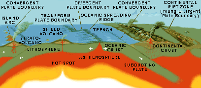
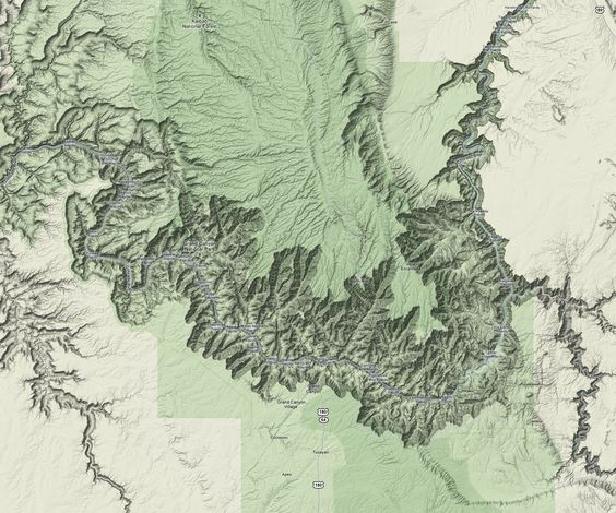