I don't have television. I don't know how extensively the Malaysian disaster was covered. I've heard that CNN over-did it, no surprise. People may have had enough of the story by now, but my version here comes with a twist, with the idea that Americans may have - repeat may have -- taken this plane down. There are problems in certain reports that people have not been made aware of, because the news is always slanted toward the word of "experts." You may have noticed that even the experts are in disagreement.
In the beginning, we heard that the Malaysian military was not watching their radar screen(s) at the time. I understand how boredom might become unbearable, watching the radar screen months after months, years after years, and nobody attacks the country. It calls for many snooze-offs. But wouldn't that equipment record everything for play-back, for when the guy at the screen falls asleep? Wouldn't military radar go far more than 100 miles off shore with aircraft "vision"? Is Malaysia going to wait until enemy planes are within 100 miles before being capable of spotting them? Of course not. Yet flight 370 was not yet 100 miles off shore when it "vanished."
As soon as I heard of the circumstances of this flight's disappearance, the thought was crossing my mind that the United States used a non-explosive weapon to kill electronics on board. The motive: in opposition to China. I can't be sure of the reason. I'm not saying that I'm right or sure about this idea passing through my head. I'm just telling what went through my mind initially. And that's why I'm doing the story. Pull up a chair, and get comfortable. It's a long story; be patient for the juicier parts. I'm going to pose many questions, make many comments. This is not a pure news report.
Many instances of dates will be shared; burn it into your head that the plane went missing March 8, shortly after midnight. About three and four days later -- mid-week -- it was noted that the Malaysians seemed unstable or non-transparent in their report. The country was seemingly changing tunes, saying that, maybe, its military radar picked up the plane turning around from its scheduled path (north-east), flying west, clear across Malaysia, to the Malacca waters off the west coast. I tended to reject this as reality. Why? Am I a rebel? Everyone else accepted it. Why not me? Because, I thought the Americans downed the plane.
I began to believe that Malaysia was being confused and manipulated by the U.S. seeking to mislead the at-sea search teams. I believed the Malaysians changed their tune, mid-week, from applied U.S. pressure. Evidence for this will be addressed.
About the time that the world was becoming aggravated with the Malaysians, the Rothschild-suspect surname below went to be on CNN to get out a toxic message: "'The Malaysians deserve to be criticized -- their handling of this has been atrocious,' said Ernest Bower, a Southeast Asia specialist at the Center for Strategic and International Studies in Washington." I would consider that applied pressure on the Malaysians to get their story right, and, of course, the "right"story was what the Americans wanted them to say. As the world continued to portray Malaysia as incompetent, the Malaysian prime minister would later (around March 20) confess that his public announcements were screened, or even determined, by Americans.
http://johnib.wordpress.com/2014/03/13/malaysian-airlines-flight-370-investigators-faced-with-possibility-aircraft-hijacked/
Here you can see the applied pressure at work: "The [Malaysian] government has been criticized by some U.S. officials for not sharing information or accepting more offers of help." "Offers of help"? As in, "let us help you draw our own conclusions"?
Nearly a week after March 8, Malaysian authorities, namely the defence minister, did a news session, saying that the plane "vanished." I do not think he would use that word if he believed the plane turned back and flew over Malaysia again, where it would be caught on military radar all the while. That scenario would require another term besides "vanish." It would be more like, "a hijacker got away from us." I will share his public announcement not far below.
It's one unlikely coincidence that Malaysian military radar would cease tracking the plane at the same instance of transponder loss. I am of the opinion that the military radar was incapable of tracking this plane, at the time, even to 100 miles out. Perhaps the radar system was shut off for repairs, but something is wrong in this regard. Yes, the prime minister has said that military radar tracked the plane to the west coast, but I'm rejecting that claim. I'll show you some serious fractures in his story.
There has been no report of a neighboring country's airport / radar system spotting a plane where it shouldn't have been. It doesn't seem to have crossed into another national border.
About four days into the loss, it was learned that a New-Zealander with a McKay surname emailed Malaysian authorities immediately (day one) regarding a bright fire ("burning", his term) he saw, high in the dark sky. He claimed that the timing was about right for flight 370's disappearance. The sending of this email was confirmed by ABC. The Malaysians didn't bother to respond to his email because they probably knew that it was a faked sighting.
The Mackays are actually a Rothschild line, for Rothschilds and Bowers trace back to Mackays at Moray. Bowers share five bunched arrows, a favored symbol in the Arms of Rothschild, with Camerons, and David Cameron happens to be the British prime minister at this time.
I was thinking that this Mr. McKay, supposedly an oil-rig worker, was planted by the West to divert rescue teams hundreds of miles east (where he was positioned) from the flight path.
Days later, he sent another email to his employer, which was soon published in minor websites; virtually no major media did a story on it. Why not? By what coincidence could a fire in the sky have occurred at the virtual time of flight 370's disappearance? It's highly unlikely that it could be coincidental. On second thought, I gave Mr. McKay the benefit of the doubt, and while he could not have seen the plane from his position, I am entertaining that he saw a missile fired that took down flight 370. I'll explain later. I'll tell you why a missile was needed after loss of transponder contact.
The McKay email reads as though written by an experienced pilot more than an oil-rig worker. The plane, the message implied, was flying directly toward him (mainly east) or away from him. He said that the plane was not moving laterally from his eye-shot, meaning that it could not have been going north or south. He said that it was high in the sky, as many as 70 kilometers away, but, really, it's a light in the sky after midnight; how could one venture a guess as to distance? I thought that the perpetrators were seeking to lure searchers way east of the expected crash site with this information.
The implication of his report is that the plane was hijacked, flown east for about 300 miles (less than an hour) after loss of contact with the airport, at which point it burst into flames, suggesting a large bomb on board near the fuel tanks. Here's a photo of the second message:
http://www.thewire.com/global/2014/03/oil-rig-worker-says-he-saw-malaysia-air-flight-370-go-down/359093/
About the next day, some buzzing reports were going around the blogging sites concerning a superior theory. Always beware that kind of uppity talk, for it's expected from perpetrators of globalist crimes, when they seek to convince the masses of a false story. The theory was: the plane had flown for hours on auto-pilot, after the oxygen had escaped from the plane and put all on board "to sleep." Without evidence, the one who created this superior theory claimed that the plane flew over, and crashed into, the Indian ocean. This theory would be short-lived due to being over-shadowed by a report, the next day, from a satellite company. This company likewise believed, at that time, that the plane crashed into the Indian ocean. Coincidence?
In other words, it seemed to me that efforts were being made by perpetrators to mislead search parties well east of, and well west of, the place where I think the plane crashed: in the gulf of Thailand.
A U.S. official (did not disclose his name) came out to say that the United States had evidence of "ping" communications, between the plane and a satellite, for hours after the pilot was last heard from. It is these pings that I'm going to take issue with, something that the world has been compelled to believe as fact. I'm going to play a different tune.
My thoughts in real time, in regards to the pings, were: no way, this is a diversion; the Americans are seeking to take all search parties out of the gulf of Thailand, and have them comb the Indian ocean instead, if possible.
The Americans even sent their own ship into the open sea immediately, to urge others to follow suit. I get it: any countries not following suit will be deemed heartlessly irresponsible. It placed pressure on Malaysia to follow suit. I imagine the Americans working the phones to convince all nations involved in the search not to waste precious time in the gulf of Thailand. The Americans now had bona fide "ping" evidence that flight 370 was on the west side of Malaysia, which is why I paid careful attention as to how this evidence was framed.
That American ship was stationed, until then, in the Malacca straight. What was it doing there? The other nations were busy searching the gulf of Thailand. Who caused some of the search parties to go into the Malacca straight instead? Some would say the Malaysians did, by their announcing the possibility that flight 370 flew there. But I think it was the U.S. that caused search parties to get into Malacca. I took the position that the American perpetrators were biting their nails until all search parties left the gulf of Thailand.
It took about two weeks for the satellite company to disclose publicly that it gave its ping analysis fairly quickly to certain Americans, who then relayed it to the Malaysians.
This is what happened: 1) Americans relayed satellite information to Malaysia, claiming that the plane turned around and headed west; 2) the Malaysian government was not certain concerning this satellite evidence (why not? why not just believe?), and remained somewhat aloof from it for a few days; 3) the Malaysian military decided to deny this scenario; 4) the Malaysian prime minister, by week's end (about the 15th), decided to agree with the scenario in spite of the defence minister's position.
The Malaysian military must have caught on to the America trick:
KUALA LUMPUR, March 13 (Bernama) -- Following is the statement by Defence Minister and acting Transport Minister Datuk Seri Hishammuddin Tun Hussein at a press briefing on the search for the missing flight, MH370, in Sepang, Selangor, Thursday:
"It is now six days since MH370 disappeared...
..."Before I take questions, I would like to clear up a few issues.
Engine Data
"I would like to refer to news reports suggesting that the aircraft may have continued flying for some time after the last contact. As Malaysia Airlines will confirm shortly, those reports are inaccurate.
"The last [ACARS] transmission from the aircraft was at 0107 which indicated that everything was normal. Rolls Royce and Boeing teams are here in Kuala Lumpur and have worked with MAS and the investigations team since Sunday. This issue has never been raised.
"Whenever there are new details, they must be corroborated [creating doubt in the NEW details raised by Americans]. Since today's media reports, MAS has asked Rolls Royce and Boeing specifically about this data. As far as Rolls Royce and Boeing are concerned, those reports [that the plane flew for hours after loss of contact] are inaccurate.
http://www.bernama.com.my/bernama/v7/ge/newsgeneral.php?id=1021705
Rolls Royce is important here, for it's the company receiving the flight's automatic transmissions. What the defence minister seems to be saying, along with companies responsible for the airplane, is that the satellite-ping claim cannot be accurate / true. It's a lot like calling the Americans, and the satellite company, liars. Why would the U.S. lie about something like this? Why would the satellite company claim more pings than there actually were? Does it matter whether there were two pings, or four, or eight? Of course it matters. Giving the Malaysians false information in this disaster, matters.
The Malaysian military must have known something in order for the defence minister to deny the ping scenario. Whatever you think of my theory, as I draw it here, you can't say I don't have something to make me suspicious.
Note the inter-woven fact in the comment/opinion below (March 14): the American naval vessel was in the Malacca waters rather than in the gulf of Thailand:
[Theory 2] The plane crashed to the west of Malaysia, in the Indian Ocean. Via ABC News: Malaysian authorities have requested the United States move its destroyer, the USS Kidd, previously stationed at the edge of the strait of Malacca, further west to the Indian Ocean. Pentagon officials said the USS Kidd is now sailing towards a location where the Indian Ocean meets the Andaman Sea, where Malaysian officials now believe the plane may have crashed. http://www.people.com/people/article/0,,20796971,00.html
Unbelievable. ABC was told (by someone, unless it was a dream) that the Malaysians requested for the American ship to go into the Indian ocean! The reality is, there was a rift between the U.S. and Malaysia at this point, and the Americans wished to lead without making it appear so. Aside from that, it's important that no U.S. craft were in the gulf of Thailand, so far as I've read, and I've read plenty. Furthermore, to prove that Malaysia was not open to the ping interpretation, their search parties, and those of other nations, remained in the gulf of Thailand all week long. Surely, if the Malaysians took the ping claims seriously, they would have abandoned those waters immediately.
To re-phrase: why didn't the Malaysians become instantly convinced with the ping claims of the satellite company? Is it a small question?
After the Malaysian prime minister accepted the ping interpretation, though it may have been more lip-service than heart-felt, TWO HUGE possible flight paths were being reported, increasing the search area by many times, but away from the gulf of Thailand. Where CNN shares this claim, we find: "The revelation comes as CNN has learned that a classified analysis of electronic and satellite data suggests the flight likely crashed either in the Bay of Bengal or elsewhere in the Indian Ocean...The analysis used radar data and satellite pings to calculate that the plane diverted...and then either flew in a northwest direction toward the Bay of Bengal or southwest into the Indian Ocean."
Later, about two weeks into the disaster, the satellite company official confessed publicly that their people thought, from the beginning, that the plane flew south into the Indian Ocean. The statements at that time indicate that it was the Americans who wished to have the northern route as part of the possibilities. While you can see in the CNN report above that the plane was not thought to enter the main land mass, yet, such reports were being taken seriously soon after. Who is it that wants the world to believe that the plane could have flown onto the continent? Is Obama involved in creating a faked, terrorist scenario sometime in the future? By what coincidence does the ping interpretation supposedly include a flight path smack to Iran / Afghanistan??? Is this a set-up?
At the same briefing, the Malaysian defence minister apologized as best he could for diverting attention toward Malacca early in the week:
Radar Signal
"It suggested that there was a possibility that an aircraft had passed over to the Strait of Melaka. We have a duty to investigate any possibility. We owe it to the families of those on the flight to follow up every lead.
"On that basis, we dispatched extra ships and aircraft to search the area. However, our main effort has been in the South China Sea [same as the gulf of Thailand, essentially, on the EAST side of Malaysia].
"We are working very closely with FAA and the NTSB. On the issue of the possible air turn-back, they have indicated to us that based on the information and data given by the Malaysian authorities, the US team was of the view that there were reasonable grounds for the Malaysian authorities to deploy resources to conduct search on the western side of peninsular Malaysia.
"Under the circumstances, it is appropriate to conduct a search if the evidence suggests there is a possibility of finding the missing aircraft.
What I'm seeing here is that the O-mericans were feverish to search the west side, but that the Malaysians were hesitant, yet agreed to it for fear of looking irresponsible. It's important to read the hesitancy in his words, for by this time, the American organizations mentioned in the quote had the ping information. Perhaps the defence minister saw through the Americans as they implored that all search vessels be taken out of the gulf of Thailand. Perhaps it made him suspicious.
The announcement went on:
..."I want to touch on the question of Malaysia's response. First, this situation is unprecedented. MH370 went completely silent whilst over the open ocean. We are in the middle of a multinational search involving many countries and more than 80 ships and aircraft...
...Again, let me be clear: there is no real precedent for a situation like this. The plane vanished. We extended the search area because it is our duty to follow every lead. We owe it to the families. And we will not give up."
http://www.bernama.com.my/bernama/v7/ge/newsgeneral.php?id=1021705
Why does the defence minister insist on "vanish"? That's not the same as, "it flew out of our radar range on the west side of our country." When a plane flies past radar range, no one says, "it vanished." The big media have reported lock-step that the last place where Malaysian radar caught the flight was on the west side of Malaysia. In that case, Malaysian radar followed the plane clear across the country, wherefore it did not vanish under that scenario. Rather, it flew off, and no one else caught it in their radar. Nor did any satellites see it, either in flight or in the water.
I take that back. The United States claims that none of its satellites saw the plane, or a missile hitting the plane, or a burst of fire from the plane, or the plane in the water. But I think the Americans watched it happen, and saw where the plane crashed, in the gulf of Thailand. The U.S. was determined to change the search field, even having Jay Carney get that message out loud and clear:
White House spokesman says 'new information' has led them to consider searching the Indian Ocean, as opposed to the South China Sea.
...White House did not explain what the 'new information' was...
...A White House spokesman confirmed that authorities were considering the new avenue of exploration, as a Pentagon official revealed that a destroyer from the U.S. Navy had been dispatched for the search.
,,,'It's my understanding that based on some new information that's not necessarily conclusive - but new information - an additional search area may be opened in the Indian Ocean,'White House spokesman Jay Carney said. 'And we are consulting with international partners about the appropriate assets to deploy.'
Why does Carney say, "not necessarily conclusive" information? Later, the satellite company came out to say that there could be no doubt about the pings communicating with flight 370, and flight 370 alone. Therefore, the only thing in doubt was the location of the plane on the second ping (the first ping was during normal flight). This is something I'm going to take issue with. The satellite company said that the pings could indicate the location of the plane, and that the pings could not indicate the location of the plane. Which is closer to the truth, and what are the details for the ability or non-ability to pin-point the craft at each ping? Did the satellite company truly have good evidence to locate the plane in the Indian ocean, on day two or three of the disaster? The Malaysians were playing it careful, wanting the evidence, not trusting blindly.
Here's the claim in some technical terms:
WASHINGTON (AP) -- A Malaysia Airlines plane was sending signals to a satellite for four hours after the aircraft went missing, an indication that it was still flying, said a U.S. official [who?] briefed on the search for the plane.
The Boeing 777-200 wasn't transmitting data to the satellite, but was instead sending out a signal to establish contact, said the official, who spoke on condition of anonymity because he wasn't authorized to discuss the situation by name.
...continuing pings led searchers to believe the plane could have flown more than 1,000 miles (1,600 kilometers) beyond its last confirmed sighting on radar, the official said. The plane had enough fuel to fly about four more hours, he said.
http://news.yahoo.com/missing-plane-sent-signals-satellite-hours-211405973--politics.html;_ylt=AiRYTDD16XsbKwOPQVhQe._QtDMD;_ylu=X3oDMTBsNGg1aHNnBGNvbG8DYmYxBHBvcwM0BHNlYwNzcg--
Why do you think the unnamed official said four hours of flight after loss of contact? Doesn't that suggest a total of five pings only? Why did this story change to eight pings and seven hours of flight (after loss of contact)? The better question may be: WHEN did it change to eight pings and seven hours of additional flight?
More than a week after the quote below, the satellite company came out to say that it had a flight over the Indian ocean all figured out within a couple of days. Yet, as of late in the first week, as per the quote below, the Malaysians were denying the ping evidence:
[American] Investigators are still working to fully understand the information, according to one person briefed on the matter. The [ping] transmissions, this person said, were comparable to the plane "saying I'm here, I'm ready to send data."
,,,On Thursday [March 13], Malaysian aviation officials said the flight could have flown for several hours after its last contact, but they said they had received no data indicating this.
http://online.wsj.com/news/articles/SB10001424052702304914904579434653903086282?mod=WSJ_hp_RightTopStories&mg=reno64-wsj&url=http%3A%2F%2Fonline.wsj.com%2Farticle%2FSB10001424052702304914904579434653903086282.html%3Fmod%3DWSJ_hp_RightTopStories
THE MALAYSIANS HAD NO EVIDENCE THAT THE PLANE FLEW SEVERAL HOURS. That's the rift between the Americans and Malaysians all week long. Some influential arm of the government did not receive the ping evidence very well. Don't we want to know why? By Friday, the 14th:
"The Malaysian government said Friday that it can't confirm the report [that the plane went west].
And a senior U.S. official offered a conflicting account Thursday, telling CNN that "there is probably a significant likelihood" the plane is on the bottom of the Indian Ocean."
http://www.cnn.com/2014/03/14/world/asia/malaysia-airlines-plane/index.html?sr=tw031414malaysiaairlines9aVODtop
You see, the O-dministration sent its spokespeople to CNN to blab concerning the new theory: the Indian ocean. Here is someone else putting it differently:
Malaysian officials are denying U.S. investigators' report that Malaysia Airlines Flight 370 remained in the air for about four hours after it lost contact.
The Reliability of the Malaysian Government
Everything changed on March 15:
Although U.S. officials previously said they believed the plane could have remained in the air for several extra hours, Najib [Malaysian prime minister] said Saturday that the flight was still communicating with satellites until 8:11 a.m. -- seven and a half hours after takeoff, and more than 90 minutes after it was due in Beijing. There was no further communication with the plane after that time, Najib said. If the plane was still in the air, it would have been nearing its fuel limit.
"Due to the type of satellite data," Najib said, "we are unable to confirm the precise location of the plane when it last made contact with the satellite."
A U.S. official with knowledge of the investigation on Friday said the only thing the satellite can tell is how much it would need to adjust its antenna to get the strongest signal from the plane. It cannot provide the plane's exact position or which direction it flew, just how far the plane is, roughly, from the last good data-transmission location when the digital datalink system was actually sending data up to the satellite.
http://www.washingtonpost.com/world/jet-was-hijacked-malaysian-official-tells-ap/2014/03/15/ec7397d6-abff-11e3-af5f-4c56b834c4bf_print.html
Such a fast switch in position. What convinced the prime minister to play ball with the pings?
The claim by the U.S. official causes us to think that the positioning of the satellite's antenna provided the general direction and, under certain circumstances, the distance to the plane. He says that the relative distance to the plane can be figured out only if a ping is accompanied by a prior transfer of data. However, after the loss of the transponder, there was no data transfer, for the plane's responses to the satellite pings are regarded as non-data signals. In other words, as it's phrased above, relative distance to the plane cannot be determined by comparing the various ping events.
In short, I have yet to see a map showing the plane at each ping. For the trusting world, this indicates that the location of the plane at each ping cannot be figured, but for me, it indicates that there was no string of pings. I acknowledge only two pings, for reasons to be explained later.
In short: while the satellite company told that the pings are hard to read for any practical value in locating the plane, the company yet reported their analysis that the plane was way over in the west of Malaysia. What was responsible for that conclusion: 1) the ping evidence; or, 2) the Americans who insisted that Malaysian radar had the plane tracked to the west of Malaysia?
The Americans got their way: "The new leads about the plane's path, though ambiguous, have drastically changed a search operation involving more than a dozen nations. Malaysia on Saturday said that efforts would be terminated in the Gulf of Thailand and the South China Sea, the spot where the plane first disappeared from civilian radar." What a difference a day makes. Was it political pressure applied by the Americans that changed Malaysia's mind? Or did the satellite data get so "good" that the Malaysians fell for it?
The article goes on: "Malaysia has confirmed that a previously unknown radar trail [the particular plane was unknown] picked up by its military was indeed MH370. That blip suggests the plane had cut west, across the Malaysian peninsula, after severing contact with the ground." This is important. Earlier in the week, the Malaysians said, MAYBE, their radar tracked flight 370 to the west. The next day, they said, NOPE it did not. But after the prime minister was hooked on the ping interpretation of the West, he also gave the Americans their way on their interpretation of Malaysian-military radar.
Was he bribed? Obama's good at that.
Lookie: "Malaysia received help in analyzing that radar data from the United States' National Transportation Safety Board, Federal Aviation Administration, and the British Air Accident Investigation Branch" The Brits and Americans together, we should have known. They "helped" the Malaysians to see it "correctly." We are to believe that the Malaysians were unable to read their own radar data properly, until helped by the Western experts. Are you going to fall for that? Could we please see the radar blip ourselves? Isn't a major media going to ask the U.S. experts on what that blip looked like, and how they determined that it was flight 370? Isn't that question just a little important?
Another article put it this way:
The U.S. National Transportation Safety Board said in a statement that its experts in air traffic control and radar who travelled to Kuala Lumpur [where the flight took off] over the weekend [early in the crisis] were giving the Malaysians technical help in the search.
A U.S. official in Washington said the experts were shown two sets of radar records, military and civilian, and they both appeared to show the plane turning to the west and across the Malay peninsula.
http://johnib.wordpress.com/2014/03/13/malaysian-airlines-flight-370-investigators-faced-with-possibility-aircraft-hijacked/
This is very difficult. The Malaysians themselves did not simultaneously agree with that assessment, and made it plain, publicly, that they were having doubts about it. Meanwhile, I can imagine the Americans pressuring them to accept that scenario. Mr. Bower's appearance on CNN could coincide with that effort for a conniving reason. At that time, the Malaysians continued to search in the gulf of Thailand as evidence that they were not buying the assessment of the American fingers-in-their-eyes. "As of Friday (14th), China said seven of its eight deployed vessels were still scouring the Gulf of Thailand."
http://www.thehindu.com/opinion/blogs/blog-horses-for-tea/article5788311.ece
The unnamed U.S. official above even claims that the civilian radar -- the airport radar I'm assuming -- shows the plane turning around. But this claim was before an actual, civilian radar photo (from Malaysia) appeared in the news. Besides, CNN said: "Malaysian military radar showed the plane climbing to 45,000 feet soon after disappearing from civilian radar screens and then dropping to 23,000 feet before climbing again, the official said." Which was it? Did civilian radar capture the plane turning or not?
Prepare yourself for this: the radar (overhead view) below, from Flightradar24 (Google it for more information), shows the plane on its normal flight path a minute before losing transponder contact, but DOES NOT show the plane turning around. Should we ask why this is the case? Here's the radar photo:
http://www.tribwatch.com/malaysiaRadarMap.jpg
Below is the Flightradar24 page entitled: "Full flight history for Malaysia Airlines flight MH370" See what you see.
http://www.flightradar24.com/data/flights/mh370/
Suppose that the media, or some important people, clamor to see the turn-around on actual radar. It could be provided in the same way that, after clamoring by Republicans, Obama provided a fake copy of his birth certificate. Yes, a little blip can be pasted to a photo of a radar screen to fake a turn-around. But, just as Obama didn't right-away give a fake copy of the certificate because it was risky, so the radar people didn't give a faked copy of a radar photo to news media due to the risk. That's my interpretation of the Malaysians not releasing the disputed radar image(s). Nor have the Americans tried to explain why the Malaysians were unsure of their radar interpretation.
In the following, note that the position of the satellite, relative to the plane, is not given. Why not? :
According to the Malaysian government, a satellite that tracked the aircraft was located more than 22,000 miles above sea level. Even after the ACARS system was disconnected, the satellite still received some basic signal from the plane -- what one U.S. official described as a "handshake." Though no data was being transmitted, the satellite continued to reach out to the plane on an hourly basis and received confirmation that the plane was still flying.
"There's no circuit breaker [= manual switch] that would allow you to shut off the handshake," the official said
(article above).
When a satellite is 22,000 miles overhead, it's a geostationary satellite. It's in orbit, but moving parallel with the equator at roughly the same velocity as the earth's spin. The result is that the satellite "hangs" at one spot over the planet. Don't you want to know where it was hanging in relation to flight 370? I'll show it later, when I take issue with the American conclusions on the pings.
Why isn't there a headline like, "Rolls Royce Begs to Differ with U.S. Assessment?" Why are we not hearing the reasons that Rolls Royce stood with the defence minister, both in denial of the plane's westward turn-around? That minister said that Malaysian Airlines was about to make the same denial: the plane did not fly for hours. Other Malaysian "officials" (unnamed) felt the same way. Why wouldn't that be an issue in the West? Doesn't the West want the truth?
It took some days to come out, but out it came: "That satellite handshake took place on a system operated by Inmarsat, a British satellite company that provides global mobile telecommunications services." At the company's own website:
15 March 2014 -- Inmarsat has been appointed as a technical adviser to the UK Air Accident Investigation Branch on Malaysia Airlines flight MH370 to support the Malaysia investigation.
4 March 2014 -- Routine, automated signals were registered on the Inmarsat network from Malaysia Airlines flight MH370 during its flight from Kuala Lumpur."
http://www.inmarsat.com/
The company offers satellite services to private and government orgs. It started out as a non-profit handled by the UN in 1979, to WATCH maritime shipping activity. The company is now in regular business. "Aside from its commercial services, Inmarsat provides global maritime distress and safety services (GMDSS) to ships and aircraft at no charge, as a public service" The Internet is free too, but that's what makes it such a great spy tool. Anything from the UN should be watched out for the all-seeing-eye watchers. "Services include traditional voice calls, low-level data tracking systems, and high-speed Internet and other data services as well as distress and safety services" Perfect for spying, and selling data to governments.
Also, this: "The ACARS system on the [flight 370] plane is manufactured and served by Inmarsat plc (LON:ISAT), a UK satellite company. Inmarsat systems are in roughly 90 percent of long haul passenger planes worldwide.
" This is no small-potatoes company. And it was in charge of sending pings to flight 370. But might this company be able to fake "handshakes" from flight 370? I'm assuming that each handshake is simply a read-out on a computer screen or piece of paper. It might give the strength of the signal, and, perhaps, the direction from which it arrives. If statements from Inmarsat's spokespeople on how the pings may locate the plane in the Indian ocean are confusing, or akin to smoke and mirrors, we might begin to ask some questions.
The following is a hard bone to chew. Perhaps the solution is, as one blogger commented, that the plane going west may have been the sinister one involved in disabling the passenger jet. The difficult issue concerns a report telling that a certain craft on radar was supposedly 45,000 feet up, then way down, then up again. It's being said that 45,000 feet is the dangerous maximum for a 777 (Lear-jets fly at 45,000 feet normal altitude), but it's not the flying altitude that's the difficulty; it's the fact that the change in altitude was supposedly caught on Malaysian radar, yet the Malaysians didn't see it...until the Americans convinced them of it.
This craft below is not to be confused with flight 370, though the world has done just that, including experienced pilots:
The details of the radar readings were first reported by The New York Times on Friday [March 14].
Malaysian military radar showed the plane climbing to 45,000 feet soon after disappearing from civilian radar screens and then dropping to 23,000 feet before climbing again, the official said.
http://www.cnn.com/2014/03/14/world/asia/malaysia-airlines-plane/
Does the above sound like a 777, controlled by a hijacker(s)? It seems to be avoiding the 35,000-foot range, where airliners often cruise. By avoiding normal cruise levels, the craft on the radar wouldn't be seen by pilots of other passenger jets. If the craft on radar was the guilty party that shot down flight 370, we might expect it to avoid regular airliner altitudes.
How could CNN put that information out, seeming claiming that flight 370 was caught on Malaysian radar, when the Malaysian defence minister has denied it? Don't you think CNN owes the people a few comments on the defence minister's denial? Do you think CNN (and others) should be able to report claims from people unwilling to give their names? Without the person behind the statement, why should we trust?
If the plane was given a fatal shot from an electromagnet weapon, it would begin to go down, not up. That's why the perpetrators would plan on providing "evidence" for the plane going up at that time: "Citing American officials and others familiar with the investigation, the New York Times reports that radar data collected by the Malaysian military shows the plane's rapid ascent, followed a turn to the west." There you have it, the ascent was followed by a turn, PROOF POSITIVE that the plane had its engines and flying capabilities after transponder and ACARS transmissions ceased. No one could possibly think, now, that the plane went down due to a sabotaged computer system, exactly the set-up that the perpetrators would desire.
EMP (electromagnet pulse) leaves no visible fingerprints, no light flashes, and no noise. But it does require an aircraft to deliver the fatal pulse. The Americans do have planes that are giant lasers in the sky for to shoot missiles in flight. Stars wars is already on. Why couldn't they have planes that shoot electromagnet pulses? They must, but may not want other nations to know it.
The pings supposedly serve as "evidence" that the engines were running (I'm assuming that pings would not receive a clean bill of health if the plane was under water). Until we got word of the pings, theories to explain transponder and radio disappearance included faulty electrical systems on board. The pings have obliterated that theory in the minds of anyone who trusts the news people. The perpetrator with unlimited money, such as the U.S. government, would provide evidence for "proving" innocence in case he's caught on some grounds. Running engines hours after transponder-and-radio disappearance is probably hard-core "proof" that EMP had nothing to do with the mystery.
Here is the sequence of events according to the radar interpretation: 1) plane turns around; 2) plane climbs to 45,000 feet flying back toward Malaysia; 3) in much less than an hour, the plane drops to 23,000 feet and turns sharply north on a route from Malaysia toward Thailand; 4) plane flies a short distance north and turns north-west over the sea; 5) it's at normal cruise altitude at the last instance of responding to Inmarsat's ping service.
What does the zig-zag flight path, in conjunction with the altitude changes, spell out? Some are saying that it was a "careful" path, to blend in and not stand out, which doesn't explain a climb to 45,000 feet, however. If this plane were the culprit that downed flight 370, we might expect it to fly high initially to be out of sight of airliners, and to then act like a regular passenger flight. Then, while flying its northern path, it wouldn't want to cross the shore (at Burma) for fear of getting caught on military radar, and so, once its well beyond Malaysia, it makes a sudden, sharp turn toward the Indian ocean, afterwhich we are left with a mystery as to where it ended up...because Malaysian radar could not reach that far.
From the New York Times:
The erratic movements of the aircraft after it diverted course and flew over the country also raise questions about why the [Malaysian] military did not respond in real time to the flight emergency. Malaysian officials [not Malaysia's military people, necessarily] have acknowledged that military radar MAY HAVE [caps mine] picked up the plane, but have said they took no action because it did not appear hostile.http://gawker.com/flight-370-soared-above-45-000-feet-after-vanishing-re-1544098719
I don't know whether "hostile" was used by the Malaysians, and I don't know how much we can trust this statement, as phrased, anyway, but, what I think the Malaysians are saying is: we didn't see anything suspicious in this plane or any plane. Maybe they were asleep, or playing cards.
As soon as flight 370 went dead to airliner contact, one would think military radar would be called upon, at which time the military wouldn't be looking for a hostile plane only, but for any plane located where it wasn't supposed to be. How many passenger flights could there have been over tiny Malaysia in that one-hour period??? Not many. Therefore, the "hostile" statement above by Malaysia, if it did make it, seems suspicious. Military radar, if it wasn't switched off at the time, must have a recording the plane's turn around, if that's what it did, or its flight further out to sea, if that's where it went.
As the Malaysian government has decided to state that the military did catch flight 370 moving west over the country, it's likely lying, and unwilling to change it's tune now, after having committed to one. There is only one reason for the Malaysian government to do something so drastic as oppose the "vanish" position of its own military: politics. The Americans must have convinced the government that flight 370 did fly west to the Malacca strait. Denying the pings could amount to a political storm.
The Low-Flying Plane
Here is an eye-witness report that made the international news (Yahoo's Australian-news website, for one) as early as March 11, yet has seen no traction in big U.S. media (shame shame) as late as March 20:
The first report of a 'bright light descending at high speed' came from Mr Alif Fathi Abdul Hadi, 29 who said he saw the light heading towards the South China Sea at 1.45am on the night the aircraft disappeared.
Businessman Mr Alif lives in Kampung Kadok, in the far north west of the Malaysian mainland, close to the southern border of Thailand - and the light he witnessed would have been several miles to the north of the flight path the jet was on before it vanished.
http://www.darksidemedia.net/crash-site-of-flight-mh370-has-finally-been-found/
The time of 1:45 is an hour and ten minutes prior to the seismic event in the gulf of Thailand that I think was the plane crashing. I'll explain this later. The article goes on:
Lending credibility to the account by Mr. Alif is the claim by fisherman Azid Ibrahim, 55, who saw a bright light streaking overhead at 1.30am on Saturday, about 100 miles south of where Mr Alif had seen the light [other reports locate the fisherman just 20-25 miles south].
Mr Alif said the bright light was the type that aircraft use when taking off and landing at night - like a car uses its headlights.
Keep in mind that an electromagnetic-pulse weapon would NOT destroy electrical wires / circuits, but only the sensitive electronics. Lighting would still work after an EMP blast, providing that the lighting's power is not controlled by sensitive equipment.
So, the sighting by the fisherman was about 15 minutes before that of Alif Hadi (it shouldn't be "Mr. Alif"). Other websites claim that the fisherman was directly off the coast of in Kuala Besar. While I can't find a map with that location on it, headlines at Google suggest that it's in the Kelantan part of Malaysia. Another article says of these two witnesses, "Two individuals in Kelantan today..." Kelantan has a southern border (at the coast) about 25 miles south of Alif's location, wherefore I'm locating the fisherman tentatively 20-25 miles south of Alif. Therefore, the plane did not fly a straight path from the fisherman to Alif's viewpoint, for it could fly more like 100 miles in roughly 15 minutes.
Alif added: "'However, the light I saw was moving towards a completely different direction [from normal airliner traffic.] It was going towards the sea, near Bachok (which lies to the south of Mr Alif's home).' His description tends to indicate that if the light he saw was on the doomed aircraft, it had turned north instead of continuing on its regular north-easterly flight path." The last sentence makes no sense to me, as if the normal flight path was at the coast at 1:45. The writer seems confused, yet the point is well taken that Alif saw the plane moving north-ish, and more toward the sea than land, near Bachok.
We have some good material here to ponder. The location of Alif Hadi's house (about 15 miles east of Kota Bharu) is on the coast at the extreme north-eastern part of Malaysia. It is less than 200 miles (or 15-20 minutes) from the seismic event. The fisherman was not far out to sea at the time, meaning that the plane moved generally along the coast, apparently not wanting to go far inland for fear of crashing into populated areas. Perhaps the pilots were seeking to inform coastal peoples that something was wrong:
While he thought nothing of it at the time, when he learned about the missing aircraft MH370 the following day he lodged a report with police.
Mr Alif's account tended to coincide with that of fisherman. Mr Azid who told the New Straits Times: 'Usually, lights from an airplane look like distant stars at night but the one that I saw was big, as the aircraft was flying below the clouds. I followed the light for about five minutes before it disappeared [below some coconut trees].'
The low flight, less than 10 minutes after loss-of-radio contact, indicates that the pilots had turned and descended quickly, seeking to send an SOS message as best they could. One would think that a jetliner would not have wiring of both the radio and the transponders in the same place of in case an explosion / accident knocks one out with the other. For both systems to fail simultaneously, an EMP attack is on the list of options.
So, the plane was already low while flying over the fisherman, and was then "descending" about 15 minutes later over Alif's area. How, then do we harmonize this picture with the report held to by the Malaysian prime minister, that the plane was ascending to 45,000 feet following it's turn-around west? That turn-around is predicted to be between 1:22 and 1:30. Only the people who have the plane on radar know the time with certainty, and that's another problem: no article I've read states when the plane started turning around. Why not? It's a detail that the Western press would like to share with us, and one they would ask the Malaysians for, yet...nothing.
Nor is the West emphasizing this low-flying plane while going hook-line-and-sinker with the 45,000-foot story. My explanation for this is that the Americans in Malaysia -- and the perpetrators -- are in cahoots with the prime minister on the 45,000 foot version of the story.
As the plane had its bright headlights on while flying over Alif's place, it wasn't trying to sneak across the airspace as a hi-hacker would. A hijacker is not predicted to fly low to make himself conspicuous. He's predicted to fly further out to sea, out of radar range, if possible.
After returning to the coast, the plane decided that it could not fly to the airport. A logical explanation is the inability to communicate with the airport, and because it did not have the ability to land. But the fact that the plane didn't even make the attempt to be seen at the airport suggests that the pilot had major flight-ability concern(s). There must have been a real chance that it could crash imminently, and he preferred to come down on the water for a softer landing if possible, or like the miraculous one at New York a few years ago.
Or, the wing controls needed for climbing to higher elevations may have been destroyed, in which case the plane may not have had the ability, or at least the good chance, to fly over the central mountains (6-7,000-foot peaks) to the airport. Therefore, he stayed along the coast.
Or, the pilot may have figured that a flight toward airport radar was unnecessary because straddling the coast at low altitudes would be sufficient to alert military radar. Meanwhile, I must take it, the military-radar guy was not watching the radar screen. This could explain any cover up from the Malaysians, and why the prime minister is going with the 45,000-foot theory, i.e. to deny that flight 370 was this low-flying plane. The military would be directly responsible for this flight's disappearance if its people were not watching the radar screen at the time.
The information from Alif and Azid suggests that the plane initially turned north a few miles at sea from the coast, still out of cell-tower range. There is a question as to whether an EMP attack would render cell phones in-operable. The flight then passed Alif's area into Thailand's airspace, I assume, after which the mystery begins. As I haven't heard of other reports concerning the sighting of this plane, I would assume that it stayed out at sea, with the pilots trying to decide what to do next.
I don't see how anyone can write this low-flying plane off without concern, but, as was said, the Malaysians had decided to go with the 45,000-foot story, thus setting up the scenario of wholly ignoring this plane. But how can it be ignored? Doesn't the military have an obligation to tell which particular flight the low-flying plane was? Don't the Chinese deserve to hear an explanation too? What plane was it, and why was it so low? The western media? Totally irresponsible in answering these questions, or even asking them. What is going on? The American officials must be ignoring this story like the criminal burying the smoking gun.
A Daily Mail article has yet another intriguing claim: "MH370 spotted at 1.28am, eight minutes after it stopped communicating • Turned towards Butterworth, a Malaysian city along the Strait of Malacca" That's about all the article says on this matter. It doesn't tell the full flight path, nor whether it reached Butterworth. "Heading toward" is not exactly precise co-ordinates. Butterworth is due west of the fisherman's location at 1:30, on the opposite shore of Malaysia.
The article adds only this: "Malaysian officials have said the plane might ultimately have passed through northern Thailand, but Thai Air Chief Marshal Prajin Juntong told reporters Tuesday that the country's northern radar did not detect it." Don't you think all focus should be on the details of the Thailand radar? How high was the plane, according to Thailand radar? Was it the low flight, or the one going to 45,000 feet? Did the Thai's release this information to give the Malaysians the scare of their lives?
Are the Thai's trying to send the message that, look it, we have the low-flying plane on our radar? Are they seeking to force the Malaysians and Americans to come clean? The problem is, the Thais are not giving the news people the plane's altitude, and moreover the Thais seem to be playing a favor to the Americans by mentioning Butterworth on the west coast. The Thais do have some political ties with the U.S., after all.
Azid the fisherman saw the plane flying "below the clouds." It sounds less than 10,000 feet. As it was descending some 15 minutes later, it may have been as low as 5,000 feet, which can explain why radar in northern Thailand did not see this plane. If it was 45,000 feet high, northern Thailand would have been able to see it. But informing the world that the northern radar did not catch it, Thailand seems to be telling that the plane did not fly 45,000 feet.
The Americans are predicted to want to shut the Thais up, silence them on their letting loose their radar picture. One way to do this is to embarrass them, ask why the Thais did not release their radar data from the start. The question creates doubt in the Thai report. There are no better character assassins than the O-mericans.
From a New Straits Times report: "Alif said he watched the light's movement for about five minutes, before realizing that it was descending. However, he said he was not sure that it was an airplane as he only saw the light. He said there was no blinking red light. "I did not think much about it, and went to sleep." As a possible example of lighting that may not work after an EMP attack, the exterior, blinking night lights...may be set up to go on and off automatically by a computerized instrument detecting nightfall and dawn. It's logical. The headlights would not be on an automatic situation, as they are needed at varied times for night landings. The headlights would be hard-wired, therefore, with no computer needed in the circuit.
http://www.nst.com.my/latest/font-color-red-missing-mh370-font-man-claims-possible-sighting-of-airliner-1.505683?ModPagespeed=noscript
Planes may at times need to circle airports waiting for an opportunity to land, but Alif's house was more than 200 miles from the airport. Plus, plane's do not circle low, in order to keep noise levels down for people. Why was a plane flying with its headlights on, more than 200 miles from the airport? It wanted to be seen by the people. It was in trouble, wasn't it? The passengers were freaking out, weren't they, and the Malaysians are playing politics with the disastrous outcome of the flight, aren't they?
In another article: "According to [Azid], the plane was flying so low that he could see the lights 'as big as coconuts'."
http://www.thestar.com.my/News/Nation/2014/03/11/Kelantan-duo-report-seeing-lights-falling-at-high-speed/
The following is from a Malaysian report, in the Malaysian language:
Quick translation (I'm Malaysian): Kota Bharu - A fisherman here claims to have seen an unusually low flying jet in the South China Sea, approximately 8 nautical miles from Kuala Besar, Pantai Cahaya Bulan early the day before last.
...According to him, the plane was flying low heading away from Malaysia towards the middle of the sea.
"At the time only Pak Da (friend) and myself saw the plane. The rest for asleep. It's usual for us to see planes flying low in this area because it's a main pathway, but this time it seemed lower than usual.
I'm not sure how high it was from the sea level, just that I saw big headlights below the clouds. That's what surprised me," he said when contacted last night.
...After that, he made a police report at the Regional Police Headquarters in Kota Bharu yesterday evening.
http://www.reddit.com/r/news/comments/200owp/comprehensive_timeline_malaysia_airlines_flight/
In this scenario -- flying AWAY from Malaysia -- it means that the plane, under duress, circled back and reached, or nearly reached, the Malaysian shore, afterwhich it turned back seaward (not necessarily due east), flying over the fisherman. There needs to be an explanation as to why a plane in duress would not want to cross the shore, at least not very far past the shore.
We shouldn't assume from the fisherman's words above that the plane flew east over his head: "While a fisherman said he spotted an aircraft flying very low about 10 nautical miles off Kuala Besar, heading towards Thailand." That's a northward direction, generally toward Alif's place. Yet, according to Alif's testimony, the plane had moved closer to the coast between 1:30 and 1:45. It had been curving about, therefore, for 25 minutes since losing radio contact. It's fairly easy and certain to plot its path to that point.
http://www.ntv7.com.my/7edition/local-en/prayforMH370_OBJECT_RESEMBLING_AIRCRAFT_SPOTTED_IN_KELANTAN_ON_NIGHT_MH370_WENT_MISSING.html
There is a question as to whether we should believe Thailand, coming out some 10 days after the disappearance to say, "Hey, guess what; we had the flight on our radar, but we didn't tell anyone until now because no one asked us." That's my wording, not theirs, but the excuse used is exactly Thailand's. Nobody asked them for the radar??? It may sound heartless to not share radar under the mysterious circumstances of this flight, but, on second thought, the Thais probably believed that Malaysian radar had the plane clearly on its own radar, and so why bother sharing their own, low-quality radar? As we will see, it was of low quality. In the meantime, sharing the radar picture reveals to everyone just how far Thai radar can see, a thing the Thais would have wanted to avoid.
The following is needed here to show that the Thais are not mortal enemies of the Americans. This concerns my attempt to explain why the Thais said the plane was headed to Butterworth: it was doing the Americans a favor by trying to harmonize with the American view of the flight path. The Thais may not have wanted to go steeply counter the American version of the developing story for fear of souring political ties:
According to a 2012 Gallup public opinion poll, 60% of Thais approve of U.S. leadership under the Obama Administration, with 14% disapproving and 26% uncertain...According to Barry McCaffrey, a US four-star general, 'the excellent U.S.-Thai counter-narcotics relationship has been an enormous success and stimulus for greater regional cooperation'...According to Shawn Crispin, the Asia Times Southeast Asia editor, Thailand represents one of the U.S.'s 'once strong, now strained bilateral alliances'." Mhttp://en.wikipedia.org/wiki/Thailand%E2%80%93United_States_relations#Current_bilateral_issues
There is enough there to show that Thais needed to walk carefully on egg shells when releasing their radar picture. They stopped short of predicting / revealing the plane's altitude, and did not give the co-ordinates of the plane when first spotted at 1:28. The mention of Butterworth gives the impression that the plane was, eventually anyway, well over the Malaysian land mass. That's what's problematic for me.
Malaysia is not predicted to ask the Thais whether this plane they saw was high or low, for Malaysia is sold on the 45,000-foot story, and wishes to avoid more changing of their tune. It would be difficult for Malaysia to come out now to say, "oops, it was just 10,000 feet at the time, not 45,000."
As the flight lost transponder action at 1:21, there are about nine minutes between that event and the sighting by the fisherman (the news said 1:30, but that may be approximate). A plane at 550 mph can move about 90 miles in ten minutes. It can be shown that flight 360 was indeed able to make it to the fisherman by 1:30. I hope you don't mind a little easy math to make this point.
The plane had taken off some 40 minutes before 1:21, but, due to the need to rise, it wasn't averaging 500 mph when leaving the country initially. That's to say that the plane was not out to sea as far as 500 mph would take it over 40 minutes. If I'm not mistaken, I read that the plane was about 85 miles off the coast of Malaysia at 1:21, which would place it about 260 miles from the airport (my calculation from my atlas). That last number is a little low, in my guess-timation; it should be more like 300 miles from the airport. However, if there was a curved flight path 300 miles long, it could yet locate the plane just 85 miles off the coast at 1:41. I'll show the civilian radar picture again below, where one can calculate the plane's distance from shore to be less than 100 miles at 1:40 am. It's extremely important, because these numbers are all perfect for predicting that flight 370 turned had around IMMEDIATELY after losing transponder / radio contact, then flew over the fisherman on its first arrival to the Malaysian coast.
There wasn't enough time to reach the coast and then fly over the fisherman. Before reaching land and cell towers, the pilot apparently decided to curve the plane north toward Bachok rather than flying toward the airport any longer. There were cell towers there.
Not surprisingly, Thailand changed it's excuse the following day, suggesting that it simply let the Malaysians handle things using their own radar:
Ten days after a Malaysian jetliner disappeared, Thailand's military said Tuesday it saw radar blips that might have been from the missing plane but didn't report it "because we did not pay attention to it."
Military officials in neighbouring Thailand said Tuesday their own radar showed an unidentified plane, possibly Flight 370, flying toward the strait beginning minutes after the Malaysian jet's transponder signal was lost.
Air force spokesman Air Vice Marshal Montol Suchookorn said the Thai military doesn't know whether the plane it detected was Flight 370.
...Montol said that at 1:28 a.m., Thai military radar "was able to detect a signal, which was not a normal signal, of a plane flying in the direction opposite from the MH370 plane," back toward Kuala Lumpur. The plane later turned right, toward Butterworth, a Malaysian city along the Strait of Malacca. The radar signal was infrequent [low quality] and did not include data such as the flight number.
......On Monday, they [the Malaysians] backtracked on the timing of the first switch-off, saying it was possible that both were cut around the same time, leading to new speculation that some kind of sudden mechanical or electrical failure might explain the flight going off-course.
...A Chinese civilian aviation official has said there was no sign of the plane entering the country's airspace on commercial radar.
http://www.ctvnews.ca/world/thailand-s-military-says-its-radar-might-have-tracked-missing-malaysian-plane-1.1734438
The reason why the Thais may not be certain as to whether the blip on their radar was flight 370 is that this plane may have been too low for the 45,000 figure used by Malaysians. The Thais are claiming, however, that at 1:28, a plane was flying in the opposite direction (south-west) that flight 370 should have been flying, and moreover flying in the general path that flight 370 should have been on. Does anyone really need more evidence that this was flight 370?
If it wasn't 370, it would be easy for the Malaysians to identify which plane it was, taking that route, toward the airport, at that time. Hello? Is there anyone home in Malaysia? Which plane was this? Are not the Malaysian people going to demand an answer from their government? Hello? Is there anyone home in China? Are the Chinese not going to demand an answer?
The key in the Thai report is that the plane turned "right" toward Butterworth while flying south-west. Perhaps Thailand deliberately "granted" the truth to the world in order to squeal on the American picture without seemingly doing so. Generally speaking, a plane turning right toward Butterworth while flying south-west is predicted to be at a latitude to the south of the latitude that Butterworth is at. However, the Alif and Azid sightings does not allow for it. Instead, the sightings require that the right turn was made at a latitude to the north of the Butterworth latitude. For one thing, it means that the right turn was hardly a 90-degree turn, but more like a 40-degree turn at maximum.
The important point is that the path, after the right turn, goes directly over the fisherman's air space. That is, a straight line from the well-predicted point of the craft at 1:28, to Butterworth, goes directly over the fisherman's general area. It tends to verify that the Thai radar report concerns the same plane seen by the two Malaysian witnesses. Thailand may be saying, "Look, we've had enough with the lies; here's what really happened."
The Thais may even believe that the plane flew to the Malacca strait...because the Thais don't really know one way or the other, in that their radar lost contact with the plane at some point while headed to Butterworth. Therefore, we want to know when the Thais lost contact with this plane. How close to Butterworth was it at the time?
The initial path of flight 370 to Beijing was on the north side of Kuala Terengannu (see map), about 50 miles south of the fisherman. The 1:28 time on the Thai radar would suggest a flight location still over the sea, and nearing the Malaysian shore for the first time. The fisherman did not see or hear this approach, safe to say. It's to be assumed that this pass was a little to his south, and, as the Thais say, toward the airport. That tends to eliminate the idea of a hijacking, wouldn't you say? What hijacker would want to go to the airport? It suggests trouble on board. Yet, the plane did not go to the airport. It was able to fly, but it did not go to the airport.
The flight path to Beijing, according to this radar-image map, crossed the eastern Malaysian coast on the same latitude as Butterworth. The latter (not shown) is smack beside George Town (shown), and Bachok is shown too. You can easily make out the flight path from all the information above. The southern border of Kelantan (where the fisherman was roughly located) is the grey line under the last letters of "Bachok."
The Fisherman was, "approximately 8 nautical miles from Kuala Besar, Pantai Cahaya Bulan." This location has a marina with some military hardware and government boats. It's not where a hijacker would want to go; it's where a pilot in distress might want to go. There is an airport nearby with a runway only a half mile long.
Why didn't the Thais keep a lock on this plane as it flew toward Butterworth? Why do they say "radar signal was infrequent"? I'm taking the position that the Thais lost contact when the plane became too low to "see," and that the plane was on the outer limits of radar capture.
From the information released by Thailand, we don't know how deeply over the Malaysian land mass the plane was before it turned right. It must not have been over the land mass at all, for at 1:30, we are expecting it to be flying over the fisherman's head, eight-to-ten miles out to sea. Therefore, it was headed toward Butterworth while still at sea. Why did the Thais give such a misleading impression? Why did they say the plane was headed for a location on the west coast when it hadn't yet arrived to the east coast? My only solution is that Thailand needed to keep on good relations with Malaysians and/or Americans, and so attempted to seemingly jibe with their picture of things. Yet, the Thais technically told the truth: the plane turned right toward Butterworth.
The radar picture above is from http://www.flightradar24.com/. It boasts: "Track air traffic in real time from all around the world! " This map tends to give us an example of what the airport radar looks like. There are few plane's in the sea to Malaysia's east at 1:40. How could the Malaysian military get confused concerning the tracking of flight 370??? Why did it say that it could not be sure whether it was tracking flight 370 to the Malacca straight? Just look at that radar picture. The military radar would look identical, would it not? How could one possibly lose flight 370, or not be sure which blip it was, at 1:43, or 1:45, or 1:46, 147, and so on? Scratch your head all you need to, because there is no explanation, especially when the defence minister says that the plane "vanished." From the start, the Malaysians were saying that the flight vanished.
It didn't vanish, after all, did it? Instead, the plane got into serious trouble, and the military did nothing about it salvaging it from a crash. If we ask why the Americans aren't exposing this irresponsibility, it's a better question than at first meets the eye. If the O-mericans (not to be confused with Americans) wanted the truth, they would expose that this flight did not go west. But the O-mericans want the world to believe that the flight went west, and therefore the Malaysians are finding some comfort in tagging along with this false claim. The Malaysians can now maintain that the plane disappeared due to a hijacking. It takes them out of hot water, if the trick works in the long run.
The O-mericans claim to have seen both the civilian and military radars of the Malaysians. Am I saying that they are lying about seeing flight 370 on those radars? Yes, unless the Malaysian created faked radar images, inserting a faked flight 370 westward, which the O-mericans found convenient for their own game. Here's the time line:
1) O-mericans convinced the Malaysians that the flight went to the west side of their country;
2) Malaysians find it convenient to latch onto the idea;
3) Americans and others ask to see the radar pictures;
4) Malaysians create a tampered radar recording;
5) O-mericans know it's faked, but don't complain, because it works for them too.
At the radar image, the "01:20" in the information box is the time. The ":41" is the Actual Time Departure. figure stands for 41 minutes after midnight, the take-off time. One can use this radar map to calculate that the plane was less than 100 miles off shore at 1:20am. In the information box, we see that the plane was moving at 473 knots, about 545 mph. The height is shown at 35,000 feet exactly.
Between the east coast and the airport of concern, there are central mountains with peaks 6-7,000 feet. As the plane was already low over the fisherman's head, it's in some doubt that the pilot was intending, at that early point, to fly back to the airport. Yet he was flying TOWARD the airport, a very natural thing to do in the first minutes of shock. One can imagine the pilots very nervous with a severe problem on their hands. The quick descent by 1:30 suggests that the flight to the airport was abandoned in the first couple of minutes...unless the plane was descending by force of some loss of controls.
Earth-Shaking Event Ignored
Here's an interesting thing:
Chinese researchers say they recorded a "seafloor event" in waters around Malaysia and Vietnam about an hour and a half after the missing plane's last known contact. The event was recorded in a non-seismic region about 116 kilometers (72 miles) northeast of the plane's last confirmed location, the University of Science and Technology of China said.
"Judging from the time and location of the two events, the seafloor event may have been caused by MH370 crashing into the sea," said a statement posted on the university's website.
However, U.S. Geological Survey earthquake scientist Harley Benz said Friday that the event appeared to be consistent with a naturally occurring 2.7-magnitude earthquake
(CNN article above).
It seems doubtful that a plane falling to the sea floor could cause a seismic event of any speakable level. I tended to reject this claim when first reading it, because I envisioned a plane falling through the waters after it was afloat for some time, meaning that it wouldn't hit the sea floor very hard.
Secondly, I cannot trust anything inside the U.S. on this story. The country, at the highest levels, is filled with Masons that could be instructed to support the U.S. agenda in this Malaysian matter.
Thirdly, by what cosmic coincidence did this "quake" occur north-east of the plane's last-known location, in roughly the very direction that it was flying, and about 90 minutes later? Astonishing, is it not?
The story lost legs immediately when the U.S. Geological Survey weighed in and said, no, it wasn't the plane, or anything having to do with the plane. I'm not going to trust the 2.7-magnitude figure, anyway. It's time we stopped automatically trusting anything inside the Unites States from authority structures. The nation's leaders have become wicked, especially under the O rule.
Perhaps it wasn't an earthquake. Can a plane explode under water? Aren't the fuel tanks water proof? Is it possible that, upon crashing on the sea floor, the fuel exploded?
China's report is at odds with the Geological report:
A "seismic event" consistent with an airplane crash has been detected on the sea floor close to where the missing Malaysia Airlines jet lost contact with air traffic control on Saturday, Chinese scientists said Friday.
The signal detected by two stations in Malaysia appeared to indicate that a small tremor occurred on the floor of the sea at 2:55 a.m. about 95 miles south of Vietnam, the scientists said in a statement posted on the website of the University of Science and Technology of China.
"Consistent with an airplane crash" is not exactly the same as a 2.7-magnitude tremor. Whose closer to the truth? My atlas has a spot, about 165 miles due west of Bachok, that reads 65 meters in depth. That's about 215 feet deep, about the length of a 777. However, the spot is 200 miles due south of the southern-most tip of Vietnam. The tremor was pin-pointed half that distance from the tip of Vietnam, where it could be less deep. A crashing plane 209 feet long, doing a near nose-dive into water 100 feet deep or less, could cause one heck of a "seismic event," don't you think?
When I think of those passengers...my face strains with sorrow.
This is a very convincing picture. The time of the seismic event was 96 minutes after the pilot said "good night," 94 after transponder / radio loss, about 85 after the plane flew over the fisherman, and about 70 after flying by Alif. A possible scenario is that the plane was damaged on a first pass of an electromagnetic pulse, but needed more harm to bring it down. As it flew about, the enemy was planning a second assault. What to use? Another EMP, or a missile?
Question: why did the plane leave Bachok to fly deep into the sea, so that it crashed 95 miles south of Vietnam?
I don't have the exact location of the seismic event, but, if that distance is from the southern-most tip of Vietnam, its at about 7.2 degrees latitude. On the map below, the oil rig of Mr. McKay can be figured about 300 miles east of the "quake" location so that he could not possibly have seen the plane go down. However, note at the article below that his sighting of a bright UFO is pin-pointed a little southerly from the latitude cutting across the southern-most tip of Vietnam...which plots the UFO at slightly more than 8 degrees latitude.
http://www.crimelibrary.com/blog/2014/03/12/did-this-man-see-flight-370-go-into-the-ocean-why-is-he-being-ignored/index.html
If the map disappears, see it here:
http://www.tribwatch.com/malaysiaOilRig.png
I placed two dots on my atlas, one at the pin-pointed UFO location, and the other 95 miles directly south of southern-most Vietnam. I was amazed to find that a straight line across both dots led smack to the border between Thailand and Malaysia, missing Bachok by just ten miles! At the NBC article below, where one can readily see how the Geological Survey is speaking apples-versus-oranges to this issue, the red star on the map marks the seismic event; it is only slightly to the west of the southern tip of Vietnam.
http://www.nbcnews.com/storyline/missing-jet/u-s-scientists-seismic-event-near-missing-jet-path-normal-n53061
In other words, a straight line from the rig through the seismic event goes into the area of Northern Malaysia in which the plane was last seen by Alif. Unfortunately, I cannot find the location of the rig. It's predicted to be less than 30 miles from the spot on the map above, and most likely to the east, north-east, or south-east of the spot.
The rig worker claimed to see a bright light falling in the sky with no "no lateral movement." I doubt very much that the UFO was falling straight down:
McKay wrote, "From when I first saw the burning (plane) until the flames went out (still at a high altitude) was 10-15 seconds. There was no lateral movement, so it was either coming toward our location, stationary (falling) or going away from our location." He locates the point where he made his observation as 08 22' 30.23" N, 108 42' 22.26" E, which is pinpointed on the map to the right.
I do wonder how a rig worker calculates a predicted location on earth, below an object in the night sky, to such intricate co-ordinates. Perhaps he has equipment on the rig for determining precise co-ordinates of ships at sea. Perhaps he aimed his instrument (like binoculars) in the direction of the object, as best he could recall it, and then entered an estimated distance, letting the instrument tabulate the co-ordinates. Unfortunately, Mr. McKay gives no time for his sighting, and the media have not seemingly pursued it.
I'm quite sure that the UFO was a missile shot out toward the plane. I'm not read up on missiles at all, but, for special cases at night in times of peace, I can imagine placing a long tube on the backside of a missile in order to keep the bright plume / flames from being seen from most directions. The flames would be seen only / mainly from the back side. Put it this way: it assures zero lateral movement, if one is viewing a moving object from the back side. Otherwise, the chances of seeing any random, moving object, for as long as 10 seconds, in which it's moving in neither latter direction from the viewer, are low.
There are various velocities for air-to-air missiles. Let's take a speed of 1,000 mph, and let's assume the plane, when hit by the missile, was 300 miles off from where McKay saw it. Under those circumstance, a missile would arrive to the plane in 20 minutes. It could therefore be expected to be seen by Mr. McKay at about 2:30 (the seismic event was at 2:55), leaving a few minutes for the plane to crash once struck.
Where was this missile fired from? Was Mr. McKay seeing it at its very launching from an aircraft? I doubt it, for the location he claims is too close to Vietnam radar. I would suggest that the missile was fired from a far-off location, and guided toward the plane by satellite. Mr. McKay would have seen it only on part of it curve. The curve could assure that the light would "go out" once the back end of the missile was no longer pointing sufficiently toward him. If a missile is moving parallel with the ground at rapid speed in the dark, as well as away from the viewer, it could appear to be descending. Chances are, the missile started high and was itself descending.
Chances are, flight 370 was being tracked constantly by military satellite. When the people watching it noted that is was flying out to deep sea, they had an opportunity to send in a heat-seeking missile that would not be seen by people on the coasts. I have no idea why the pilot would take the plane to deep sea.
A missile shot from the Philippines can travel straight down the center of the South China Sea to the spot where Mr. McKay was stationed. Less than a week after flight 370 went missing, this article:
The Philippines has agreed to allow the United States access to its military bases under a new security deal being negotiated by the two allies, amid mounting concern over China's increasing assertiveness in the disputed waters of the South China Sea.
The offer was made during a sixth round of talks held in Washington last week, Filipino officials said on Friday...
...Friction between China and the Philippines...
On Sunday [the day after flight 370 flew], three Chinese coast guard ships stopped two Filipino civilian vessels from delivering food, water and construction materials to troops based on a ship that was deliberately run aground on reef in the Spratlys in 1999 to reinforce the Philippines' claim.
Manila called the Chinese actions "a clear and urgent threat to the rights and interests of the Philippines".
http://www.reuters.com/article/2014/03/14/us-philippines-usa-idUSBREA2D0GE20140314
I didn't know this when starting this article. I didn't know it until moments after creating the theory that the missile may have come from a U.S. base in the Philippines. It was amazing to find this article as soon as I googled, "U.S. military base in the Philippines"". It had been my impression from day one that flight 370 was downed as per making a wicked O-merican statement against China. The Philippines is now allowing the Americans to act as their strong arm. The O-mericans, by agreeing to this deal, are simply getting in China's face.
Math Does not Support the Flight to the West
Let's carry the story over to the Malacca straight. When this section is finished, remember: the Malaysians in mid-week were not sure of whether to go with this story, wherefore the story is likely the result of American pressure.
Malaysia's air force chief said on Wednesday an aircraft that COULD HAVE [leaves doubt] been the missing plane was plotted on military radar at 2:15 a.m., 200 miles northwest of Penang Island off Malaysia's west coast [this was at the GIVAL waypoint].
This position marks the limit of Malaysia's military radar in that part of the country, a fourth source familiar with the investigation told Reuters.
...The fact that the aircraft - if it was MH370 - had lost contact with air traffic control and was invisible to civilian radar suggested someone on board had turned off its communication systems, the first two sources said.
This tends to reveal that the airport was not using "primary" radar, the type used by the military, the type that bounces radio waves off the planes. It tends to reveal that the airport was using a radar as part of the transponder system. As the claim seems to be that the airport did not track the plane as if cut west across Malaysia, why did American officials seemingly claim that both the turn-around and the flight across Malaysia had been studied by them? Wasn't that just a sound made through their blow-horn media to cause us to trust this account?
Penang is the small island where George Town is located, and so it's smack beside Butterworth. The plane supposedly flew past Penang before turning north to GIVAL, though most maps showing the flight path do not indicate this northerly route, perhaps because it's problematic to the claims:
Reuters quoted Malaysian military officials as saying the Boeing [as soon as it lost contact] then abruptly turned west to another well-known waypoint, VAMPI...It then turned north to the waypoint GIVAL, south of Phuket [see map below]. It then sharply turned northeast to the waypoint IGREX, which is just south of the Andamans and along the route to Port Blair. That was the last point of tracking by Malaysian military officials. http://www.thehindu.com/opinion/blogs/blog-horses-for-tea/article5788311.ece
It's important that Malaysian military claimed 2:45 as the last point in which their radar caught the plane flying away...maybe, if this was flight 370. The route above is a zig-zag, first southwest, then north, then northwest. Why would a normal flight take such a route? It looks suspicious. But this was NOT flight 370. The route was either fabricated completely, or there was some suspicious plane in the area that took this route.
Let's go on with the Reuters quote to show that the plane was at GIVAL at 2:15, and we'll then ask if these times jibe with the two Malaysian witnesses:
The military track suggests it then turned sharply westwards [at about 1:21], heading towards a waypoint called "Vampi", northeast of Indonesia's Aceh province and a navigational point used for planes following route N571 to the Middle East.
From there, the plot indicates the plane flew towards a waypoint called "Gival", south of the Thai island of Phuket, and was last plotted heading northwest towards another waypoint called "Igrex", on route P628 that would take it over the Andaman Islands and which carriers use to fly towards Europe.
The time was then 2:15 a.m. That is the same time given by the air force chief on Wednesday, who gave no information on that plane's possible direction.
The sources said Malaysia was requesting raw radar data from neighbours Thailand, Indonesia and India, which has a naval base in the Andaman Islands.
http://www.reuters.com/article/2014/03/14/us-malaysia-airlines-radar-exclusive-idUSBREA2D0DG20140314
The map at the Phuket article shows the Thailand-Malaysia border at the bottom, with Phuket in Thailand. Why would Thai radar capture a plane way down on the border while not capturing the plane off of Phuket? If the Thais don't have this zig-zagging plane, was it ever a reality?
The way in which the article is written makes it uncertain where the plane was at 2:15, whether at GIVAL (Phuket) or at IGREX. However, as Malaysians said that they last caught the plane at 2:40, at IGREX obviously, the plane must have been at Phuket at 2:15. As there are about 290 miles (quite-accurate calculation on my part) between the two waypoints, 25 minutes is not sufficient time, but close, to reach IGREX. It's close enough that it checks out for the 2:15 time to be at GIVAL.
For the important calculation below this paragraph, I've got dots in pencil on my atlas to determine the distances between the waypoints. GIVAL is at exactly 7 degrees latitude and exactly 98 degrees longitude. VAMPI is at 6° 10' 56N 97° 35' 8E (6.2 degrees and 97.6 degrees). IGREX is at 9° 43' 28N 94° 25' 0E (9.7 degrees and 94.4 degrees).
My close calculations show a straight-line distance of about 375 miles between Bachok and GIVAL, under the condition that the plane took the zig-zag route that the Malaysians claimed. That's not good for the claim. The plane was at Bachok at 1:45, allowing just 30 minutes to get first to VAMPI (310 miles from Bachok) and then north to GIVAL (65 miles). That's 375 miles in 30 minutes = 750 mph, more than 150 mph beyond the 777's top speed. In the meantime, the plane was supposedly ascending, then descending, then ascending again, and curving about to boot. It's a big problem, especially as the plane was heading north at 1:45 i.e. it's not expected to turn west on a dime at 1:45.
Let's not neglect the likelihood that the creators of this fabrication did not take into account the Malaysian witnesses. The fabricators simply calculated the time needed between the turn-around point (1:21) and VAMPI (435 miles), then added 65 miles to reach GIVAL, for a total of 500 miles in 54 minutes = 555 mph. It works like a charm...when the plane is not located at Bachok at 1:45. In their scheme, they had the plane flying fast past Bachok at about 1:33.
Between the two schemes, there's a difference of only 12 minutes, i.e. the 100 miles between the turn-around point and Bachok. Yet, that small difference is like Colombo finding the little clue that lands the murderer in jail with an indefensible frown of his face. The small difference brings the plane to 750 mph on average, an impossibility.
The situation becomes worse for them if we consider the claim that the plane did not fly a straight line to VAMPI, but did a curved line through Penang. It's 260 miles from the turn-around point (1:21) to Penang, an additional 205 miles to VAMPI, and 65 miles more to GIVAL, for a total of 530 miles in 54 minutes (from 1:21 to 2:15) = 590 mph, the plane's top speed. Under this situation strained to the max, why did they have the plane ascending and descending in addition? Probably, they didn't think anyone would do the intricate math, as I just did.
If one draws a straight line from the turn-around point to Penang (same as Butterworth, remember), it goes smack over the fisherman's head. The Thais said that the plane was headed toward Butterworth shortly after 1:28. We can see here why the Malaysians and/or O-mericans wanted a high flight...which did not appear in the news immediately. It took some days. It can now be gleaned that they needed the high flight in order to not have it confused with the low flight of the fisherman and Alif. The officials y deceived the world because Alif put in a police report about a plane at 1:45, which is the sort of tiny clue that Colombo uses to land murderers in jail.
Below is a map showing the waypoints. The map shows an erroneous flight path with a huge loop over the gulf of Thailand (there was no time for a huge loop, or the average mph figure would be higher than the plane could fly), and no zig-zag shown between VAMPI and GIVAL.
http://www.tribwatch.com/malaysiaWaypoints.jpg
The comment number 6 on the map says that the plane descended from 45,000 to 23,000 feet "on the approach to Penang", yet the flight path on the map is nowhere near Penang, but rather closer to Phuket (the latter is the small blip under the red box saying "GIVAL"). Be assured, I've done many measurements repeatedly, on an atlas, over a period of several days. I'm being as careful as could be with my numbers. The only thing missing is a white trench coat and a cigar.
The zig-zagged route can be a fabrication due to the Malaysians committing early in the week to having the plane at GIVAL at 2:15. If there was a straight-line path, more or less, to GIVAL (405 miles), the average velocity would have been 450 mph, on the low side, they may have figured. If you think about it, there simply is no logical reason for the zig-zag path starting at VAMPI.
Let's consider the possibility that this zig-zag was produced by a plane, but not by flight 370. In this picture, the plan was pre-determined to have a civilian-like military plane deliver the electromagnetic pulse, then fly west to act as though it were flight 370 on the military radar. The O-mericans on the ground would do the rest by convincing the Malaysians that this was 370. To explain the zig-zag, this plane needed to go north as part of the plan to appear headed toward the Middle-East, but simultaneously needed to appear as though a hijacker was involved. The zig-zag has been reported specifically in conjunction with a hijacking scenario.
The Plausibility of Electromagnetic-Pulse Weapon
Here the story gets bizarre (keep your head on):
Before It's News just received an urgent email from someone whom we consider a very trusted source warning that there is now a "strong possibility" according to several retired US Military officers that the missing Malaysian 370 was being prepared to be used as an EMP "stealth" weapon to attack America. We've also been warned that this airplane was likely being repainted and its transponder being altered to fake both its origin as well as its destination, making Malaysia 370 the ultimate stealth weapon...
I just received a phone call from someone I trust that rocked me to my core, regarding a possible scenario to be played out with this missing airliner, Malaysia Flight 370.
The prospect, regarded as a strong possibility by three retired flag officers, is to offload the passengers at a military hangar, load a EMP weapon aboard, re-load passengers, and fly it at high altitude over the United States for detonation.
http://beforeitsnews.com/war-and-conflict/2014/03/sources-warn-malaysia-370-stealth-emp-attack-investigators-actively-pursuing-diversion-plan-2451090.html
If anything like this takes place, it's the doing of the O-mericans themselves. The idea that a passenger plane can be modified to a stealth -- unseen by radar -- craft is as ridiculous as Santa sneaking down a chimney and stuffing himself into a sock in preparation for giving the country the surprise of its life. Closer to a real possibility would be that the O-merican circle of globalists / idealists are seeking to take over their political enemies' (Americans) assets via a faked terrorist plot.
Why exactly are U.S. O-fficials not permitted to speak on the flight-370 issue, and yet they do? What kind of a world is this, where the news we are to trust is from nameless, faceless "officials"? The man who ordered the downing of this plane could be the "official" in the news, for all we know, faking concern and providing misleading information. He could be part of the team that went to Malaysia to "help" the Malaysians gets their "facts" straight.
The Malaysian government could NOT have agreed with a tracking of flight 370 to the west side of Malaysia had the British satellite data not been tossed into the thick of things. It is impossible for the Malaysians to reject the data from the British satellite (even if it's been faked) without being accused by the West of advancing a lunatic conspiracy theory. And the Westerners knew this from the start. They bank on such a strategy.
The Malaysians did not announce flight 370 turning around for days. What does that tell you? It didn't have it on its radar. How difficult could it have been to read their radar screen between 1:20 and 2:20 am in an effort to eliminate all planes that were on their scheduled routes? If there was one plane remaining after eliminating all scheduled flights, it would be suspect as flight 370. Yet the Malaysians did NOT report any such plane over a period of two, perhaps three days. The O-mericans flew out to Malaysia either late Saturday or on Sunday, the day or day after the plane went missing. No time to lose in accomplishing a pre-determined task.
On the 15th, a new apparent direction for the nameless delinquents:
U.S. intelligence officials are leaning toward the theory that "those in the cockpit" -- the pilots of Malaysia Airlines Flight 370 -- were deliberately responsible for the mysterious disappearance of the commercial jetliner, a U.S. official with direct knowledge of the latest thinking told CNN on Saturday.
There are Americans, and then there are O-mericans. It's hard to tell which is which if their names do not appear in the news. But "intelligence officials" suggest the CIA or FBI, and for me, that's the O-mericans in this case. We can therefore assume that the pre-determined plot was to convince the world that the pilot himself had planned to hijack the plane. Again, while the ping-satellite people were bent on a theory that the plane flew out into the Indian ocean, suggesting a suicide or an accident ending up in a crash, it was the Americans who insisted on a northern route toward Iran / Afghanistan. Why would they suggest such an impossibility? Who in their right minds would believe such a story? Americans would, if their respected official's said so in the media blow horns.
Why would a suicide scenario be treated as a respectable theory when it comes from a "respected" political tool, yet a conspiracy theory involving wicked politicians is treated with ridicule and scorn? Which is harder to believe, that a single pilot would kill 239 passengers and crew, or that a globalist military machine like that of Unites States would kill 239 passengers and crew?
The West is involved in seeking to Westernize, or make West-friendly nations of, countries in China's backyard, as with Russia's back yard, explaining why China and Russia have cause to form an alliance against Western intrusions. They don't want a porn-ridden, faggot-respecting society filled with divisive liberals whose only happiness is in upsetting the norms. A conservative is defined as one who likes the couch where grandmother had it, at the logical spot. A liberal is one who thinks that turning the couch upside-down is stylish and progressive. Obama ran on "change" because he's a typical, dissatisfied liberal soul seeking satisfaction in all the wrong things, and, rather than seeking to improve the things that are, he prefers to turn things upside-down nor inside-out.
Here's from yet another March-15 report: On Saturday, investigators said it was all but 'conclusive' that Flight 370 had been hijacked by a trained and highly skilled pilot. The same Hindu article says: "Malaysian military radars picked up an aircraft at 2.40 am..at a location hundreds of kilometers west of the Gulf of Thailand." Which plane was it, really?
Below is a photo of a laser-beam-shooting jet in the possession of the Americans. It looks like a passenger jet, by no coincidence. It's built to hide amongst airliners, if necessary, isn't it? What if it also has electromagnetic-pulse capability? What if there are similar planes able to fire electromagnet pulses...as they fly by other jets?? As the pulses penetrate through the skin of the aircraft so that no visible exit hole is needed, how would any random pilot in the skies know that such a weaponized plane was just that? What happens when such planes can fly around to disable other planes with ease? At one time, when engines did not depend on electronic / computerized controls, this was impossible. But lately, it's easy.
http://en.wikipedia.org/wiki/Boeing_YAL-1
But the [U.S.] military ran into problems when it came to finding out more about the effects of these [electromagnetic] pulses. How could they create this kind of powerful pulse without letting off nuclear bombs? Researchers everywhere took up the challenge.
The scientists knew that the key was to produce intense but short-lived pulses of electric current. Feeding these pulses into an antenna pumps out powerful electromagnetic waves with a broad range of frequencies. The broader the range, the higher the chance that something electrical will absorb them and burn out.
Researchers quickly realised the most damaging pulses are those that contain high frequencies...If a computer cable picks up a powerful electromagnetic pulse, the resulting power surge may fry the computer chips.
To cook up high-frequency microwaves, scientists need electrical pulses that come and go in a flash--around 100 picoseconds, or one ten-billionth of a second...Pass this pulse into an antenna and it releases a blast of electromagnetic energy. Marx generators tend to be heavy, but they can be triggered repeatedly to fire a series of powerful pulses in quick succession.
Marx generators [why that name?] are at the heart of an experimental weapons system being built for the US Air Force by Applied Physical Sciences, an electronics company in Whitewater, Kansas. "We're trying to put them on either unmanned aerial vehicles or just shells or missiles in an effort to make an electromagnetic minefield," says Jon Mayes of APS. "If something flies through it, it'll knock it out." It could also be used on a plane to burn out the controls of incoming missiles, says Mayes...
...Perhaps the biggest benefit of these weapons is that they carry the tag "non-lethal". You could take out a city's communications systems without killing anyone or destroying any buildings...
...Another big plus for people thinking of using these weapons is that microwaves pass easily through the atmosphere. This means that you can set off your weapon and inflict damage without having to get close to your target...
Electromagnetic weapons can be sneaky, too. You don't have to fry everything in sight. Instead you can hit just hard enough to make electronics crash--they call it a "soft kill" in the business--and then quietly do what you came to do without the enemy ever knowing you've even been there...Benford says. "You can deny you ever did anything," he adds. "There's no shrapnel, no burning wreckage, no smoking gun."
http://www.bilderberg.org/micwaves.htm#Just
So long as the attackers can blame a downed plane on a hijacker or a pilot suicide, they can use this weapon, providing they can get a weaponized plane near enough to do the job without being seen, or assessed suspiciously if seen. Better yet, in the page below, there is a drawing showing an EMP weaponized missile, dropped from military jet. The jet doesn't need to get close at all to the target, and can be way up high. So long as a target plane is over a body of water, such a missile can be used with little concern because, after doing its job, it will drop into the water, out of sight.
http://www.ausairpower.net/ASPC-E-Bomb-Mirror.html
A Malaysian newspaper, News Straits Times, has claimed that unidentified "investigators" (could be American, could be Malaysian) have claimed that flight 370 came as low as 5,000 feet to avoid detection. This seems contradictory and false, as explained:
In an exclusive story, the government-backed paper said investigators analysing MH370's flight data revealed that the 200-tonne, fully laden twinjet descended 1,500m or even lower to evade commercial (secondary) radar coverage...
Investigators poring over MH370's flight data had said the plane had flown low and used "terrain masking" as it flew over the Bay of Bengal and headed north towards land, the NST reported.
..."Terrain masking" refers to an ability to position an aircraft so there is natural earth hiding it from the radio waves sent from the radar system. It is a technique mostly used in aerial combat where military pilots would fly at extremely low elevations upon normally hilly or mountainous terrain to "mask" their approach.
http://my.news.yahoo.com/mh370-flew-low-1-500m-avoid-detection-says-011918423.html
I don't think we need to be airliner experts to realize the falsification in this claim. First of all, last I've heard, there are no mountains in the bay of Bengal to hide between. Radar stations are predicted to be on coasts, wherefore flying low toward a coast is essentially a waste of energy and time, and alerts ships at sea that there is something wrong with such a flight. We can't say on the one hand that the hijacker was experienced, and on the other hand that he was a bozo. The perpetrators must be pulling a fabrication on the world, therefore, in their determination to "prove" that this blip on Malaysian radar was flight 370. They have one thing on their side: more than half the American public will take them seriously if they get their blow-horn experts out on the new casts. But will they?
We are not told in this article what system, in particular, caught this plane at such a low altitude. We are simply to trust the nameless investigators. Over and over again, no names are mentioned in order to reveal whether the investigators are American or Malaysian. The article (above) states that this low elevation was while the plane was headed north, no small clue as to what the fabricators are up to: they want us to think the hijacker was taking the craft to the Middle East.
We've got to assume, tentatively, that this low altitude was fabricated to start the new theory that the plane could have managed to fly thousands of miles over land, undetected. Not too many people are biting on this theory, however, and even the Inmarsat satellite company that tracked flight 370 does not want to touch it. That could be true even if the company is involved in this conspiracy. Inmarsat has a business to run so that it doesn't want to appear deluded. Nor does it wish to appear in collusion with the perpetrators of the crime.
We can assume with confidence that this low altitude was tracked before the plane got to the last waypoint (IGREX), where Malaysian radar last had the blip captured. If the claim turns out to be that the low altitude was obtained after if left IGREX waypoint, then we can suspect that Inmarsat is responsible for that idea, even if it's not admitting it. The Malaysians are staying well away from this claim:
Malaysian officials on Monday [March 17) denied knowledge of a newspaper report that the plane may have dropped to an altitude of 5,000 feet to defeat commercial radar coverage. "We are not aware of that report, and that's a thing the investigative team has to look into. It does not come from us," Malaysia Airlines CEO Ahmad Jauhari Yahya told reporters in Kuala Lumpur. CNN could not immediately confirm [the New-Straits-Times'] account.http://www.cnn.com/2014/03/17/world/asia/malaysia-plane-up-to-speed/
In a March-17 article touching on this low flight, we have a contradiction, as well as a hijacking scenario: "'The person [i.e. hijacker] who had control over the aircraft has a solid knowledge of avionics and navigation, and left a clean track. It passed LOW OVER KELANTAN [caps mine], that was true,' said officials [who?]. 'It's possible that the aircraft had hugged the terrain in some areas, that are mountainous to avoid radar detection.'" He clearly wants the world to think that the hijacker could have flown across the main continent.
Kelantan is on the east Malaysian coast. The plane was supposed to be between 45,000 and 23,000 feet between that coast and Butterworth. That's not exactly "low." The official above must be framing his statement for the task at hand, to convince others that low flight for radar evasion is to be expected. It's a poor argument, to say the best. It's a moronic puppet speaking, to make myself clear; someone's hand is up his back and putting words into his mouth.
http://www.barenakedislam.com/2014/03/17/terrain-masking-theory-malaysian-airlines-370-flew-at-or-below-5000-feet-to-avoid-local-radar-systems/
The article above has a map showing the location of the Inmarsat satellite about 2,300 miles nearly due west of the Andamans. I'll show such a map later and discuss whether it could truly track the plane to the west side of Malaysia, let alone over the two "corridors," as they are being called.
By the 23rd, no clarification on the New-Strait-Times report had come out, so far as Googling the topic was concerned. That story simply went dead. But, clearly, some Malaysian officials had been taking this idea to heart, that the plane flew low even over Malaysia. Why? Why were they contradicting the 45,000-foot story? What radar caught the plane low so that this story needed an outlet in the news? Was this the result of the Thai-radar picture, or of the Alif / Azid testimony? The following is from the New Strait Times:
Investigators [who?] are poring over the Boeing 777-200ER's flight profile to determine if it had flown low and used "terrain masking" during MOST OF THE EIGHT HOURS it was missing from the radar coverage of possibly at least three countries.
TOP OFFICIALS [caps mine], who make up the technical team that had been holed up from morning till late at night here, are looking at the possibility that the jetliner, carrying 239 people, had taken advantage of the busy airways over the Bay of Bengal. By sticking to commercial routes, the flight may not have raised the suspicion of those manning primary (military) radars of the nations it overflew. To them, MH370 would appear to be just another commercial aircraft on its way to its destination.
"The person who had control over the aircraft has a solid knowledge of avionics and navigation, and left a clean track. It passed low over Kelantan, that was true," said officials.
http://www.theguardian.com/world/2014/mar/17/mh370-contact-missing-plane-communications-disabled
These top officials, close to the prime minister, were painting the scenario of a plane into the bay of Bengal, not down south Australia way in the Indian ocean. The bay of Bengal is the route to the main continent, and to the Middle East. Do you think the O-mericans on the ground in Malaysia were taking some boys out to lunch, so to speak, so that they got to become out to lunch?
What does "left a clean track" mean? Does it mean that the plane was not caught on military radar all across the Malaysian land mass? Is this how these particular Malaysians were planning on clearing themselves for not having a radar picture of flight 370 across the land mass? Think about it. Some Malaysian officials have been clinging to a 45,000-foot story where the plane was 23,000 feet at the lowest when reaching the west coast, and then you have these other guys, who the prime minister doesn't know, so to speak (i.e. doesn't acknowledge), suggesting that the plane flew between the mountains to keep from radar. One could recall that the Malaysian defence minister and the prime minister were not seeing eye-to-eye in what particular story to put out to the public.
Think about it some more. Why would investigators look to see whether terrain masking may have been used"DURING MOST OF THE EIGHT HOURS"??? Why not assume that the plane went seaward and never attempted to cross to the continent? Why bother with a land-crossing theory in spite of the difficulties? What a useless theory to advance. Was it born from an idea being kicked around that flight 370 flew between Malaysia's mountains to keep from getting caught on Malaysian radar? Was this one of the ideas on the table for explaining to the public why the flight was not on military radar all across Malaysia?
The Malaysian prime minister has been sending out a difficult story. Here's from a blogger:
The plane did not climb to [45,000 feet] or anywhere close to it. Many a 777 pilot have written on pilot sites that a 777 would have to have a light load and be close to empty on fuel to be physically able to do so. It's claimed climb happened an hour or so after take off so it probably had 200,000 pounds or more of fuel on board. More than one current 777 line pilot has said best case would be 39,000 feet.
Trying to go higher would stall the aircraft and possibly overheat the motors. I don't know why it's so hard for reporters to do a little fact checking or at least putting a disclaimer on info before spouting it off again.
http://www.dailytech.com/Malaysian+Airlines+Flight+370+Made+Wild+Altitude+Changes/article34524.htm
Here's another thing that I'll take issue with (from the March-17 article):
Today, Reuters reports that the last words from the cockpit...were uttered after someone on board had already begun disabling one of the plane's automatic tracking systems.
...The sign-off came after one of the plane's data communication systems, which would have enabled it to be tracked beyond radar coverage, had been deliberately switched off, Hishammuddin [acting Transport minister] said yesterday.
"The answer to your question is yes, it was disabled before," he told reporters when asked if the ACARS system -- a maintenance computer that sends back data on the plane's status -- had been deactivated before the voice sign-off.
Can we trust this man? Or were his thoughts put into his head by the O-mericans? If correct, the statement means that the flight could not have been shot down by an electromagnetic pulse, which is exactly what the O-mericans would want the world to think, in case it's needed. The O-mericans would want to kill any interest that some investigators (high level or otherwise) might have in an electromagnet shoot-down. Not too many people at this time are going to think the flight was affected by an EMP, but had the false flight to the west not been sounded through the blow horns of the media, more mystery solvers would include EMP as a theory. It's a real possibility for when a plane loses its electronics capabilities inexplicably, and vanishes.
Had the plane's electronics been given a lethal dose of EMP radiation, the pilot's ability to communicate with airline controllers would be destroyed simultaneously with the debilitation of transponder and ACARS messaging. I therefore need to discredit the statement above from the Malaysian government. The following from a March-14 article effectively does so:
The Wall Street Journal reported:
Malaysia Airlines CEO Ahmad Jauhari Yahya said that based on the airline's records, the last transmission [what kind?] was at 1:07 a.m. Saturday, slightly earlier than the time that officials have said the airliner disappeared from [civilian] radar as it was flying northward over the South China Sea.
According to other reports, the plane's transponder fell silent at 1:21/22 a.m.
http://www.dailytech.com/Malaysian+Airlines+Flight+370+Made+Wild+Altitude+Changes/article34524.htm
Alright, the last transmission at 1:07 was from the ACARS system to Malaysian Airlines, meaning that there were about 15 minutes between it and loss of transponder viability. ACARS messaging was not continuous , but: "As part of maintenance agreements between Rolls Royce and Malaysian Airlines, the engines transmit live data to its global engine health monitoring center in Derby, UK for analysis every 30 minutes." This means that NO ACARS MESSAGES WERE SCHEDULED between 1:07 and 1:21. Therefore, how can the Malaysian government claim that ACARS was "disabled" before 1:21? Another lie?
After writing here, it was learned that Hishammuddin admitted error (article below) when Malaysian Airlines corrected him. Was he caught in a deliberate lie?
We learn at this article that the last voice message ("good night") came just two minutes before transponder loss. It's quite the coincidence, but then maybe not. The article itself makes a glaring error after reporting on the 8:11am ping, then saying that the plane could have gone on far from there: "With what fuel it had left [from the last-ping spot/time], the plane could have gone on to Afghanistan, Uzbekistan, or Iran..." It all sounds so expert-like, yet the picture isn't correct. That's expected where there are some people in charge seeking to twist reality.
http://www.newyorker.com/online/blogs/closeread/2014/03/the-story-of-flight-370-changes-again.html
The Terrorist-Plot Theory is Pinged with Dents
The people at Inmarsat, and/or those working with it, have created a picture wherein the ping-locations moved westward only as far as the Andaman islands. They are not making the ping-locations get any closer to India than the Andamans. It tends to give the impression that Inmarsat can, to some degree, predict the plane's co-ordinates from merely the offerings of the ping handshakes.
Where the Malaysian radar supposed failed to track the plane is exactly where the Inmarsat system takes over to attempt the rest of the story. Is that coincidental? One could view the ping theme as a bridge to get the plane from the unknown/mystery at the Andamans into the Middle East. That's how I'm approaching my investigation into Inmarsat's input.
In order for the world to know whether the Inmarsat people, and their American helpers, are reliably interpreting the pings, the details of all pings needs to be shared in a way that the person on the street can understand them. Can the ping-handshakes locate the plane at each ping? Or not? I've read reports that the Inmarsat satellite cannot, in a vacuum of other information, know the distance to the handshake, but it can know the direction of the handshake. Others weren't sure. There wasn't a clue as to what the potential was. And then we learned that Inmarsat could NOT know the direction of the pings. Finally, news organizations, including Fox, contacted Inmarsat to get it from the horse's mouth.
Early reports had the final ping while the plane was at some 35,000 feet. It suggests that the Inmarsat system is able to know the plane's altitude. But is 35,000-foot claim true, or a fabrication? If true, Inmarsat must have the ability to know the plane's altitude at each ping. Yet, in all the many articles I've loaded in order to write this account, nothing appeared with Inmarsat listing the plane's altitude's at each ping. Shouldn't Fox and others ask Inmarsat to corroborate or deny the questionable altitude of 45,000 feet, for example? Did, or did not, flight 370 descend to 23,000 feet where the Malaysians said it did? Shouldn't the media be on the phone with Inmarsat to ask these important questions? Don't you sense a conspiratorial scam?
Later, I'll share a quote from amongst the experts telling that Inmarsat can know the plane's altitude. Surely, prior to Malaysia announcing the 45,000 foot level, the Malaysians got Inmarsat's input on that idea? What was the input? If only the blow-horn media would do its job properly, we might know. It is very suspicious that no article has reported Inmarsat corroborating the flight levels claimed by the Malaysians. It is quite the mystery. How should we read this?
I've read that Inmarsat can predict a handshake's direction by how much the satellite antenna moves while seeking to "hear" the best handshake transmission possible. There is a glaring problem if this is the truth, for Inmarsat claims that it doesn't know whether the plane went south or north from the Andamans. They can't have it both ways, claiming to know the direction, and claiming not to be capable of knowing the direction. If the latter is the truth, then how do we know that any of the pings were at the Andamans?
It's important simply to point out the contradictions, for these things raise flags on what looks to me like a conspiracy to cover up a crime.
In the scenario wherein the plane got to the Andamans shortly after 3 am, while the pings were hourly at 11 minutes after the hour, the Inmarsat people may be merely assuming that the 3:11 ping (the flight's third ping) was over the Andamans. From where I had tracked the plane (whether fictitious or real) at 2:40, it's about 250 miles from the Andamans, or roughly 30 minutes of flight, wherefore the plane is predicted smack over the Andamans (or close to it) at the third ping. A straight line from GIVAL through IGREX brings one to the southern end of the Andamans.
How many more pings were there after the third one? In the beginning, we heard a maximum of five hours of flight. But the statement below changed all that: "[The plane's] last contact was at 8.11am north of the Strait of Malacca." That was from the Malaysian prime minister. No one ever heard the five-hour phrase again. From then on, it was seven to eight hours of flight...enough to reach Tehran.
"North of the Strait of Malacca" is a terrible phrase to use in this case. The north pole is north of Malacca too. The phrase can perhaps be understood best as east of the Andamans, rather than over the mainland continent. Apparently, the prime minister had the plane, after more than seven hours of flight, at the Andamans, which is where it was at the third ping. Does that sound reasonable? Nope.
It wasn't long after when we heard that some Malaysians suspected a landed plane somewhere in the Andamans area. That's a scenario that the prime minister was apparently allowing for. The plane had landed, according to some, and all pings after that were from the same spot. If that's correct, then the prime minister must have been privy to the fact that Inmarsat CANNOT know the location of the plane at any ping.
I have no problem believing that the satellite can know the relative distance to the plane by the strength of the plane's handshake signal, but to prove beyond any doubt that the satellite cannot tell the direction of the handshake, Inmarsat allowed for a southern and northern "corridor." The only way to tell the relative distance of the plane at each ping is to know with certainty where one of the pings was located, and, with certainty, they knew where the plane was at the 1:11 ping. The question is, was the second ping louder, or not louder, than the first ping? If the plane went west after the first ping, as the Malaysian story goes, the second ping should have been louder, for the satellite is suspended to the west of Malaysia. The third ping should have been louder still than the second ping. Don't you think the media should be asking such questions, and reporting the answers?
The pings are capable of telling us what direction the plane went after 1:21 am, whether east or west. However, I am convinced that there was no ping after the 2:11 ping. I am therefore convinced that Inmarsat is fabricating the pings, unless the CIA or something akin to it fabricated the handshakes and had them go to the Inmarsat satellite.
See the satellite location and the corridors in the page below. Both "corridors" are circular in shape. Do not mistaken the drawing as though all the pings after the third one occurred on a circular line (I made that mistake at first). The center lines of the corridors represent where Inmarsat, and/or the Americans working with it, plotted the last ping. As you can see, the center line of the corridors is to the east of the Andamans, meaning that the plane supposedly moved further from the satellite after the third ping (at the Andamans). Note too how eerie it is that the circular line goes smack through the seismic event (i.e. in the gulf of Thailand) where I think the crash occurred (after the second ping).
http://www.tribwatch.com/malaysiaInmarsat.jpg
What Inmarsat may have done is to deceptively take six pings from the same plane's previous flight, and claimed them for flight 370. These pings were then used as the first six of eight for flight 370, while the last two were the flights real pings, with the last one heard in the gulf of Thailand.
Why do we think the vice-president of Inmarsat came out with the following statement: He added that it is only when the plane is powered up or flying that the 'ping' is established but it would be at different locations since the aircraft is moving... In other words, the plane was not parked for hours while responding to the pings, because pings find no handshake when the engines aren't running. Even if it's the technical truth, the existence of handshakes from flight 370 may yet be fabrications.
Don't you think it would have been a good idea for Inmarsat to add a circular line for each of ping four through ping eight? That way, one could better understand the potential flight path. By sharing only the last-ping circle, they may be technically sharing the truth, and moreover may be sharing the true particulars of the actual last ping. It may be legally-comforting for them to do this, but it's of course criminal to mislead the world into thinking that the plane went down anywhere else on that circle aside from in the gulf of Thailand. Colombo could land them in jail with a frown on their faces.
Inmarsat has come out to say that Americans took part in creating the maps: "It wasn't clear how U.S. officials obtained the initial Inmarsat data, which they analyzed and helped translate into maps."
http://online.wsj.com/news/articles/SB10001424052702304026304579449680167673144
According to the Malaysian timeline of events, the second at 2:11 was on the short northerly zig-zag from VAMPI to GIVAL, more than 400 miles back from where it was at the third ping. Did the difference in ping strength between the second and third ping reflect that distance? Could the ping strengths, or shapes, of all eight pings be made part of the international news, so that we can all be the judges on whether Inmarsat has been responsible in its information? Such information has changed the shape of the search effort, after all.
"When the plane was still missing on Sunday (the day after it disappeared), our engineers looked at the network data and realised that the plane had been sending signals," Inmarsat Senior Vice President Chris McLaughlin told IBTimes UK.
"We couldn't say what direction it had gone in, but the plane wasn't standing still because the signals were getting longer, i.e. further in distance from our satellite."
...The Inmarsat Classic Aero is installed in 90% of the world's commercial jets, and it is this little box which sent out the pings of information.
http://www.ibtimes.co.uk/malaysia-airlines-flight-mh370-would-have-been-found-if-communications-box-had-10-upgrade-1441174
First, we learn that the shape of a signal is "longer" as it gets weaker. Second, we learn that the signals continued to become longer as evidence that the plane got further away from the satellite. However, look at how little the distance from the satellite changed over supposedly eight pings, and nearly eight hours of flight. In the map above, the first ping and the eighth ping are at the very same distance from the satellite. Coincidence, or is there something amiss in the released information from Inmarsat?
In the map below, the central rings are more to the east than in the map above, but, still, the distance from the satellite changes little between first and eighth ping. Wouldn't we all like to know how far from the satellite the plane was at each ping? If Inmarsat is doing some shady and criminal here, it explains why it wouldn't want to release more ping circles, for being charged with and convicted of one false ping scenario is better than being charged with eight false pings scenarios.
http://www.tribwatch.com/malaysiaInmarsat2.jpg
"By Monday [two days after the disappearance] the team at the satellite's owners, Inmarsat, were "fairly certain" the Boeing 777 had most likely flown for around another seven hours [no one heard this seven figure, though, for days afterward].
The British firm sent its analysis to a Swiss aviation IT provider the next day, which is said to have then informed Malaysian officials the day after that - on Wednesday, March 12.
...Our engineers looked at the time between the handshakes, and they realised that the object wasn't stationary under a satellite but moving away from it," Inmarsat senior vice-president Chris McLaughlin told the Washington Post.
...The Inmarsat "pings" suggest the plane flew steadily at cruising speed of around 800km/h in the Indian Ocean...
Again, we are being led to believe that the last five pings saw the plane moving further out from the satellite than at the third ping. This is quite incredible when the plane was supposedly headed north-west nearing the plane location at the third ping. In order for the fourth-ping location of the plane to be further away from the satellite than the third-ping location (over the South Andaman island), the plane would have turned right, that being toward the north rather than left toward the west, which wouldn't bring the plane toward the Indian ocean, but rather further from it.
Likewise, in order for the fifth-ping location of the plane to be further from the satellite than at the fourth ping, the plane would need to turn more to the north still, ever moving away from the Indian ocean. Hello? Is there anyone home at Inmarsat? Inmarsat, the maker of satellites, told ABC News that they had an 'initial idea' on March 9 and by March 10 were 'fairly certain' that the search parties should look in the south Indian Ocean for the vanished plane. There story was the same, media event after media event, always telling how they believed from the start that the plane went into the Indian ocean. Yet, their ping report coupled with the Malaysian radar account gets one toward Afghanistan.
Let me stress it again. If the sixth-ping location was further away from the satellite than the fifth-ping location, while at the fifth ping the plane was moving north-west, the plane could not have come closer to the Indian ocean by the sixth ping. The situation would remain the same, with the plane's nose shifting ever more to the north, until the eight ping.
The plane at the 8th ping would be 800 miles further from the satellite than the plane at the third ping because there are 800 miles between the Andamans (third-ping location) and the nearest part of the eighth-ping corridor circle. As the time involved over the five pings was five hours, the plane would have flown, say, 2,500 miles forward while simultaneously moving 800 miles further from the satellite. Regardless of the strength of each handshake signal, the fact always remains: 2,500 miles forward, and 800 miles further from the satellite. It's easy to plot this on a map. Draw your dot to represent the satellite. Then find a spot on the map that is 2800 miles northward of the satellite while being 2500 miles from South Andaman island. (The 2800 figure consists of 2,000 miles between the Andaman island and the satellite, plus the 800 more mentioned above.)
The accuracy of the specific location of the plane at the eighth ping now depends only on the accuracy of the dot representing the satellite. The two corridor maps at the links above do not locate the satellite precisely the same. If the map at the first map link above is used, the satellite is over the equator at 64.5 degrees. With that plotted, a smooth flight curve from South Andaman is, on my atlas, through central India, then to about 50 miles west of Lahore in Pakistan, then directly over Kabul in Afghanistan. The last ping would be about 400 miles nearly due west of Tashkent in Uzbekistan. It should be added that the page in the atlas used for this calculation has longitudinal lines becoming tighter toward the north pole; I don't know how this might adversely affect the calculation, if at all.
The path above assumes that the fourth ping location was nearer to the satellite that the third-ping location. If it was the other way around, the plane would be forced to fly to the east side of Calcutta, then over the Himalayas, then to Uzbekistan, for a longer route.
That flight path would change depending on the average velocity of the plane. I used 500 mph because Inmarsat said "The Inmarsat 'pings' suggest the plane flew steadily at cruising speed of around 800km/h", which is roughly 500 mph. Inmarsat could of course be wrong with that velocity figure. If the average of 550 mph is used, the calculation is that the plane would receive it's last ping near the east shore of the Caspian sea, about 200 miles north of the Iranian border.
Of course, the plane did not fly this route. The calculations have been made to show the "coincidence" of the plane going to the anti-American part of the world, which may suggest an O-plot by the sick-O president of the O-nited States to conduct a faked terrorist act for to be blamed on anti-Americans in the Middle East.
The other point is to show that Inmarsat is providing false information. The person who thinks I'm exaggerating my claims should try to answer: why this false information? The only way for the plane to fly into the Indian ocean while keeping to the "facts" as reported by the Inmarsat vice-president is for the plane to turn south between 2:40 am (nearing the IGREX waypoint) and the 3:11 ping. I'll agree, there is plenty of time for such a turn, but why should it be an expected event when the plane has flown northwest for 300 previous miles from GIVAL, and 65 miles due north previous to that? It doesn't look like the pilot wanted to go south.
Who arranged for this northward route? Not the pilot of flight 370, because the plane never did take that route. It must have been the O-mericans who arranged that northward route, therefore, by some trickery.
In an article entitled, "What Satellite Data Reveal About Flight 370's Location", by the Wall Street Journal:
"Because the angle and distance of the aircraft relative to the orbiting satellite changed as the jet flew over the Earth's surface, each ping...to Flight 370 gave Malaysian officials, the National Transportation Safety Board, the Federal Aviation Administration and the U.K.'s Air Accidents Investigation Branch enough information to plot the 777's speed, altitude and changing path." Wonderful. So how about a map of all the ping locations??? Better yet, tell us why the people overseeing the Inmarsat data are unwilling for us to have such a map.
http://online.wsj.com/news/articles/SB10001424052702304914904579441931123347374
Note above that the satellite people claim to be able to discover the plane's change of altitudinal position. That's a minor change, relatively speaking, as compared to the great height of the satellite. It suggests that the antenna is highly sensitive to changing power levels of the incoming handshake signal.
The initial flight to Beijing was about 2,700 miles (calculation on my atlas). If correct (as per the prime minister's claim) that the flight had 1.5 extra hour of fuel, the maximum distance would be about 3,500 miles, plus glide distance to a crash. It is about 3,500 miles to where I plotted the plane in Uzbekistan. It's doubtful that the plane would still be in the air at that point, unless the pilot had a death wish. It's doubtful anyone would attempt a hijacking with a predetermined plan to fly to the Caspian sea with the fuel available on this plane.
Put it this way, that if the problem is as described in the next sentence, Inmarsat would have just said so plainly. Inmarsat did not know the position of the plane on the first or second ping, and could therefore not know the position on the remaining pings. Inmarsat has yet to reveal whether it knew the position of the plane at the first or second ping. It's a very simple and expected question for the media to ask and report on. Therefore, what exactly is going on in high places?
To put it another way, can the satellite determine the plane's location at any one handshake whatsoever, or does it need to know by other means where at least one handshake is located before it can track the next handshake(s)?
Malaysia's government, concerned about corroborating the data and dealing with internal disagreements about how much information to release, didn't publicly acknowledge Inmarsat's information until March 15, during a news conference with Prime Minister Najib Razak.
...Within hours of Flight 370's disappearance on March 8, Inmarsat started searching for clues. What little data it had on the short flight before it disappeared was provided to SITA, a Swiss aviation IT company, on the same day, Inmarsat said.
Late that weekend, Inmarsat's team delved into its databases to retrieve periodic "pings,"...The hourly signals provided a crucial clue that the missing 777 most likely remained intact with its engines presumably running hours after it lost contact with civilian radar.
Inmarsat Senior Vice President Chris McLaughlin said that on Monday, March 10, it began extrapolating the location of the jetliner using the aircraft's changing angle and distance to the satellite...Mr. McLaughlin said the data was shared the following day with SITA, which in turn shared it with Malaysian officials.
...The Inmarsat package, which included a map of the twin north and south corridors, together with readouts of data from a communication satellite, demonstrated the need for a dramatic shift in search areas, according to people briefed on the investigation.
...Mr. Najib, the prime minister, had instructed his officials early on that all information coming in be corroborated with agencies such as the U.S. National Transportation Safety Board and the Federal Aviation Administration before releasing the information publicly, Malaysian officials say. They say that was intended to minimize red herrings in the search.
...Inmarsat officials, meanwhile, became concerned the data weren't being acted upon quickly enough to help overhaul the search, according to a person familiar with the sequence of events. It turned last Wednesday to U.K. security authorities to more quickly disseminate the data, according to two industry officials. Malaysia Airlines, in turn, instructed SITA to use the U.K. Air Accidents Investigation Branch as the primary conduit for Inmarsat's data, one of these officials said.
Publicly, Malaysian officials gave little new information. Asked last Thursday what data from the aircraft investigators were relying on, Malaysia Airlines CEO Ahmad Jauhari Yahya said "no more systems from the plane" had provided information about the jet's whereabouts. That day, Malaysia's acting transport minister said that "whenever there are new details they must be corroborated."
It wasn't clear how U.S. officials obtained the initial Inmarsat data, which they analyzed and helped translate into maps. Regardless, people briefed on the probe agree it took longer than expected for the information to spread from engineers and technical experts who cranked out the first version of the data to policy makers and then back down to officials directing specific elements of the searches.
-- Marietta Cauchi and Charles Hutzler [Hitler variation?] contributed to this article.
http://online.wsj.com/news/articles/SB10001424052702304026304579449680167673144
The INMARSAT PACKAGE. Basically, Inmarsat is admitting that it, with some British elements, pressured Malaysia to adopt its corridor-map scenario, while Malaysia was hesitant. I'm sure that Malaysian satellite experts were in on the conversations and decisions, and that the military experts were there too, yet the defence minister seemed skeptical. Finally, political pressure made the Malaysians adopt the corridor scenario.
We read that the satellite had the ability to determine the "aircraft's changing angle and distance to the satellite." That is plain English, but seems to be saying that only the CHANGING distance was known, not the precise distance. There is reason to doubt this statement, because, as was said above, the satellite should be able to know the plane's location based on any one ping event, regardless of any other input. Assuming that I'm wrong, and Inmarsat is telling it like it is, then, in order to create a corridor map as we have seen it, Inmarsat had to have some outside source indicating where the plane was located to begin with. If the plane was not tracked by Malaysian radar to the west of Malaysia, the corridor map is garbage.
I see a conspiracy, pre-planned, to make the world believe that the plane got to the Andamans, so that the corridor data could make it appear that the plane ended up in the Iran / Afghanistan theater, perhaps even into Russia. For what it's worth, see the below, but note that voiceofrussia.com is carrying the story too:
Malaysian Airlines flight 370 was deliberately targeted for hijacking, according to Captain Field McConnell, a retired Delta Airlines pilot and a retired United States Air Force F4 and F16 fighter pilot.
Capt. McConnell cites industrial espionage for a cutting edge military technology as the reason behind the airliner's disappearance. "There were 20 Chinese software engineers in the aircraft, riding as passengers, and they were working for Freescale Technology in Austin, Texas, and they had the intellectual property of an open patent. In other word{s}, a patent had been applied for, but yet --- not yet granted. And the ownership of that patent was 20%, 20%, 20%, 20% and 20% for the U.S. Corporation named Freescale. And until that patent is granted, there is no ownership," McConnell said.
"The technology they were working on was a way to make stealthy a non-stealth aircraft. In other words, they could take an aircraft that does not have a stealth capability" and make it stealth, McConnell said.
..."And I will just give you four nations that are probably wrestling over these technologies for military advantage: Those being China, Russia, the United States and a British corporation called Serco," McConnell said.
http://voiceofrussia.com/us/2014_03_18/Stealth-Technology-Seizure-Behind-MH370-Disappearance-5715/
In this picture, someone wanted the Chinese scientists dead. The question: why haven't the big media picked up on this story? is it a false report, or are the big media governed by the O-merican perpetrators?
The senior vice president of British satellite company Inmarsat told Fox News' Megyn Kelly Thursday..."Just like a cell phone, each piece of equipment has its own SIM card and its own registration number," McLaughlin said. "We are absolutely certain we were seeing the readings from this particular aircraft."
Had the plane crashed when it initially lost contact, McLaughlin said those "pings" would have stopped. He said when the signals eventually went dark, it was likely because the jet ran out of fuel.
..On Friday, an international search for possible debris resumed in the southern Indian Ocean, with China sending three warships and an icebreaker to join search planes [all thanks to the Inmarsat corridor package]
http://www.foxnews.com/world/2014/03/20/satellite-company-official-speaks-out-on-tracking-missing-jet-after-it-lost/
It is very compelling to agree with Inmarsat that they were indeed tracking flight 370 for as long as eight pings. There are only two different explanations: 1) Inmarsat is lying with a false representation of the eight pings: 2) something like the CIA is able to feign hourly pings from flight 380. One needs to look at the entire, big picture when attempting to answer this. If one simply stares at the McLaughlin statement above, it looks like he's simply telling the truth, no more questions needed.
Is it logical that a hijacker would run the plane to the point of running out of fuel, in the Indian ocean, yet? Of course not. Therefore, if Inmarsat's picture is questionable from that angle alone, why should we trust it's ping scenario?
The first public announcement from the Malaysian prime minister, on the ping theme, was that the plane at the eighth ping was north of the Malacca strait. Thus, he and/or his team of investigators (may have included the Americans) gave no credibility to the Indian-ocean concept that Inmarsat had suggested from the start. The northerly route was as much a part of this scam as the Indian-ocean route, but, as you can see, the Chinese have rejected the northern route for obvious reason: it's of even less credibility than the Indian-ocean scenario.
Possibly, the next expectation is physical evidence for the plane planted at some location by the perpetrators, then "found" by the perpetrators.
Here's an early statement for telling what the ping is about: "David Coiley, vice president of aviation products at Inmarsat, is quoted by The Guardian as saying: 'When the [satellite] system is not transmitting or receiving data on the aircraft, it will send network signalling info to establish that the aircraft satellite communication is switched on, to say that the system could communicate. If we haven't seen any activity from an aircraft or ship it's a check. It' a simple acknowledgement. The ping doesn't say anything other than that the satellite communications is functioning." The company is implying that the plane was on for all eight pings, and that responses to the pings carried no data by which to form an opinion on the plane's location. You will find this uncertainty in other Inmarsat statements. The trick is, therefore, to find other statements telling that there was no uncertainty, as in the claim below:
The pings ceased at a point over the Indian Ocean, while the aircraft was at a normal cruise altitude, say two [unnamed, faceless] people familiar with the jet's last known position.
...Until just a few years ago [as late as 2009, anyway], the satellite communication system used by jetliners didn't include data on an aircraft's location in the pings...
...In the case of the missing Malaysian jetliner, PRECISE LOCATIONS WERE PROVIDED. However, it is unclear why the transmission ceased and where the plane may have ended up after the final ping.
http://online.wsj.com/news/articles/SB10001424052702304914904579439653701712312?mod=WSJ_hp_LEFTTopStories&mg=reno64-wsj&url=http%3A%2F%2Fonline.wsj.com%2Farticle%2FSB10001424052702304914904579439653701712312.html%3Fmod%3DWSJ_hp_LEFTTopStories
There you have a March-14 statement from people directly involved with the investigation, claiming that Inmarsat knows the precise location of the plane at the pings, and yet, Wall Street Journal, the one reporting the news, doesn't make it an issue that this statement contradicts the two-corridor scenario.
There is no other way to interpret the pings, on a northerly route, except by having the plane fly smack across India, which is why this is important that India mocks the perpetrators of this fantasy: "Indian security sources 'rubbish' idea that plane flew near an Indian city" Kazakhstan denies: "Kazakhstan says there was no 'unsanctioned use' of its air space."
We are not able to create a scenario in which the plane took a sharp path due north from the Andamans in order to skirt around India, for it then needs to fly over China in order to get to Uzbekistan. Here's from the Wall Street Journal: "The track from northern Thailand to Kazakhstan crosses some of the most heavily militarized airspace in the world, including western China. According to the industry official, many of those nations 'would have MiGs up in the sky before you even knew it' to intercept any unidentified flying object"
http://online.wsj.com/news/articles/SB10001424052702304017604579443603302188102?mod=WSJ_qtoverview_wsjlatest&mg=reno64-wsj&url=http%3A%2F%2Fonline.wsj.com%2Farticle%2FSB10001424052702304017604579443603302188102.html%3Fmod%3DWSJ_qtoverview_wsjlatest
Why does the statement use "Kazakhstan" as a final flight point? That country is to the north side of Uzbekistan. In fact, with the 8th ping that I plotted, the plane could conceivably have enough fuel to cross into Kazakhstan's Caspian-sea area. Who wants us to believe that the plane flew up to Kazakhstan?
As the Inmarsat ping claims now stand, we cannot create a scenario in which the plane skirted around the southern tip of India because Inmarsat said the plane got further away from the satellite, ping after ping. I'm assuming that the third and fourth pings, especially, apply to that claim.
As I understand the Inmarsat statement, the plane became progressively further from the satellite with each ping. Inmarsat's vice-president suggested this while not adding that, between any two pings (after the second one), the plane got closer to the satellite. The conclusion is that the plane never got as far from the satellite as on the eighth ping.
Look at this garbage that Fox news is displaying unashamedly:
Retired Lt. Gen. Thomas McInerney...is suggesting searchers looking for the missing Malaysia Airlines Boeing 777 take a look at possible landing spots in Taliban-controlled Pakistan.
In an interview with Sean Hannity of Fox News, McInerney, now a contributor to the network, said his recommendation was based on information from sources he was unwilling to disclose on television as well as the analysis of an intelligence service called LIGNET.
McInerney said the free world needs to be worried until the location of the jet..."My concern is if this airplane could be used as a bearer of a weapon of mass destruction or.."
http://www.wnd.com/2014/03/top-general-heres-where-to-look-for-missing-jet/?cat_orig=world
O No. The FBI is Involved
The FBI, the organization that frames innocent people and kills them if necessary: "It has also been revealed that the pilot's wife and three children moved out of the family home the day before the plane went missing [needs verification, details]. It comes as FBI investigators say the disappearance of MH370 may have been "an act of piracy" and the possibility that hundreds of passengers are being held at an unknown location has not been ruled out." Oh no, now we know who some of the "officials" are who are trying to make this look like a hijacking. There's a map and flight-path drawings at this website:
http://www.dailymail.co.uk/news/article-2581817/Doomed-airliner-pilot-political-fanatic-Hours-taking-control-flight-MH370-attended-trial-jailed-opposition-leader-sodomite.html
The FBI has been in Malaysia, and in the pilot's home. They have taken some of his equipment. I recall the FBI planting faked evidence inside computers for to frame the Chechen brothers for the explosion at Boston Marathon. I recall the FBI creating a fake scene showing the brothers walking along the sidewalk "suspiciously" toward the explosion sites. The FBI created all sorts of false evidence to pin the bombing on those boys. Now, the FBI is working hard to reveal what the pilot of flight 370 deleted, supposedly, from his equipment. The FBI can thus create any story it wishes by miraculously bringing back what the pilot deleted.
The great surprise now is that the pilot is being shown in photographs with a "Democracy Dead" t-shirt, something that can be created by a photo-shop artist, employed by the bakers' dozens by the FBI. The website above even shows a photo of the pilot at the trial of a political activist, seven hours before flight 370 took off. AMAZING: the activist was sentenced to years in prison, seven hours before flight 370 took off!
See here Obama wearing a Russian military uniform, so easy to do. The danger is, the FBI is passionately involved.
Where did that photo come from showing the pilot at the trial? Is it really him, or a look-alike taken from the bottomless book of FBI photo's? Or, how easy would it be to paste the head of the pilot, from one photo, onto someone else's body at a location near the trial?
Don't you think that seven hours after the trial is a little suspicious? It makes him appear very guilty, like one who snapped in anger. But I don't buy that. I don't think that, in vengeance, he would fly a plane through proper navigational through-ways, if his intention was to commit suicide. I don't think that, on a spur of the moment, he would decide to take the plane to some unknown destination, to land it there, as some sort of political maneuver or protest. He would not, especially, fly to Kazakhstan.
Either he had planned to hijack the plane long before the trial, while anticipating the guilty verdict / sentence, or the U.S. government set up this plane "accident" with the express, pre-designed purpose of framing the pilot as a political "fanatic."
Did he kill his co-pilot before stealing away with the plane? What did he tell his passengers and others at the time?
Okay, I'm the pilot of this plane. I'm mad at my country for jailing my political candidate. As soon as I cross the Malaysian shore in my plane, while still very angry, I decide to turn around and...do what? I don't know yet. Maybe I'll fly until I run out of gas. Maybe I'll ditch it into the parliament building. I know, I'll fly real high and give the crew a real scare, then I'll fly down fast and pop their ear drums. Oh what fun. I had better keep to the regular airline routes so that those dumb-bell military leaders won't get a scent of where I'm at and ruin my fun pre-maturely. I can keep flying for, like, seven hours, and make a really stinky political protest out of this. Man, I am king. Don't fool with me.
Nah.
I assume, the FBI wants you to think he snapped something just like that. The article adds that the opposition leader "Anwar Ibrahim is a broadly popular democracy icon and former deputy prime minister..." I'm having trouble wrapping my head around an anti-democratic pilot supporting a "democratic icon."
Why, if his destination was suicide, did he follow the waypoints on a zig-zag. Why didn't he just fly a straight line if his purpose was suicide? Who cares whether the radar people catch you in mid-flight on a suicide mission?
On the other hand, if this was a well-thought-out plan well before the trial of the pilot's icon, you'd think he was flying the plane to some pre-determined location. In this case, we would have a Hollywood movie, and a man with nerves of steel...to even think of it, let alone attempt a hijack fly-over on Malaysian territory. Surely, he and his people figured rightly that he would have gotten caught attempting something like that. The reason he didn't get caught flying over Malaysia is that he didn't.
There are some who are kicking around this pre-planned hijacking scenario at a highly-visible level:
In reaction, John Lindsay, former head of air safety at British Airways, told Sky News: "It would be a possibility and perhaps a probability that the aircraft is on the ground transmitting those signals.
"If this has been a very carefully orchestrated, pre-planned event then the aircraft and its passengers are the asset of the people who perpetrated this activity.
It would be bizarre to destroy your asset by running out of fuel and crashing it anonymously into one of the oceans or a land mass without declaring what the point of the exercise is.
http://news.sky.com/story/1226767/missing-plane-may-have-sent-signals-on-ground
Well said. Which is why it didn't happen, and why flight 370 did not go this route. It's hard enough to escape the Malaysian radar under such a plot, let alone cross into a neighboring country and/or beyond. So, the smart guys are now saying that the plane landed on a small island anywhere in the Bay of Bengal or the Indian Ocean. That's just too Hollywood for me. The next step would be for the pilot to call Malaysia with a message: "Get my political icon out of jail free, or these passengers are dead. You've got 12 hours." Hopefully, Gilligan won't show up, because he ruins everything.
In other words, the plot to get the world to believe that flight 370 got to the Indian ocean is experiencing some bouncy turbulence. There's a problem in finishing the picture.
Okay, so I'm the pilot, and my co-pilot is my partner in crime. We are giving each other high fives for making it out of Malaysian air space without the dumb-bell military sleepy-heads on our tail. The cockpit door behind us is locked, and the passengers are banging the dents-into-the-dents out of it, wanting our necks, but man, this is my day, just lovin' it. Hey, look, there's the runway. They cleared the trees just like they said. Let the wheels down, Jockamo, we're going in...clunkity-boing-boing-berango-de-bop-slam. There, we made it, Jocko. Didn't I tell you? We only lost one wing, and look. no fire. It's our time. Okay, now what? What's the next part of the plan? This is going to be a blockbuster.
Well, for one thing in the next part of the plan, there's the issue of no side door out of the cockpit. There's only one door out, and there are 239 would-be pilot murderers on the other side. A small complication, I'm sure, for a Hollywood scene. There's guys outside the plane, all wearing a little photo of the Malaysian opposition leader, and donning machine guns; it's their job to handle the passengers. Of course.
Fox News, which I disrespect very much, wants the world to believe that what Malaysia needs now is the FBI. Someone, Fox News says, is calling for it, but it isn't Malaysia:
Rep. Peter King expressed frustration Sunday [March 16]...suggesting the Malaysia government is not cooperating and that U.S. authorities must get more involved in what appears to be an international crime.
"This has been frustrating for the FBI," said King, R-N.Y., chairman of the House Sub-Committee on Counterterrorism and Intelligence and a former chairman of the House Committee on Homeland Security. "My understanding is the Malaysian government is not cooperating."
http://www.foxnews.com/politics/2014/03/16/king-frustrated-with-malaysia-probe-into-missing-plane-wants-more-fbi/
I see how it works. When a foreign government doesn't do things the way the U.S. globalists want it done, they go on big-time TV to bad-mouth those nations into compliance.
So, you see, the Malaysians and the U.S. have not, after all, done kissy-kissy over the weekend. All is not on the same page. There is frigid space between the two. The U.S. does not like to lose control. Globalists are control freaks, or they wouldn't be globalists. Fox News always supports globalists. What is the FBI complaint? "Much of the frustration is being directed toward Malaysian officials, who waited nine days after Malaysia Airlines Flight 370 disappeared March 8 over the Indian Ocean to search the pilot and co-pilots' home..."
The FBI complaint is that it wanted into the home sooner, so it could plant the damning evidence sooner. I'm not Malaysia, but even I don't trust the FBI, accept to toss me over a bridge if that was in its best interest. Peter has been making the rounds, no time for barbecue this weekend: "King told ABC's 'This Week' that more intelligence agencies need to be hands-on in the probe. He wants the NTSB, the FBI, the Federal Aviation Administration and the international police agency Interpol [and his grandmother] to be more involved in the investigation." It's not a wonder Malaysia is puking this weekend.
I don't know what Peter wants more; the U.S. has been given the green light to search for the black box. Hey, bring your whole navy and air force too, Malaysia has said. That's not enough for Peter. Does Peter want to control all the ships of all the nations involved in the search? Does Peter want them out of the gulf of Thailand? Is that the problem? Peter's going to lose a lot of weight in the next three weeks, because the black box will go on pinging that much longer. There will no weekend barbecue until after that.
See Continuation.
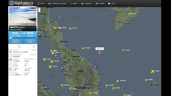
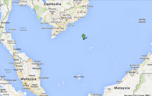
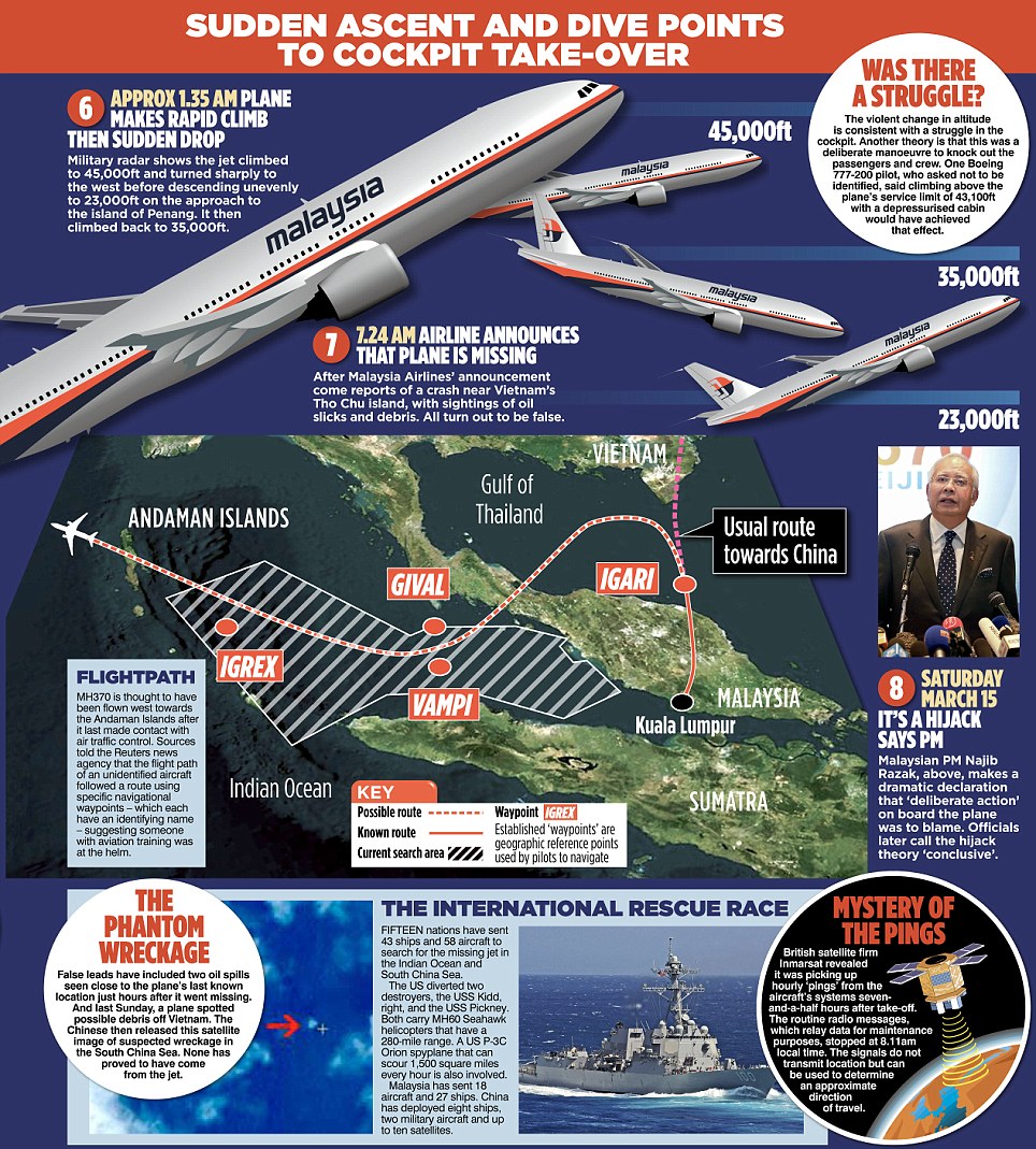
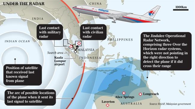